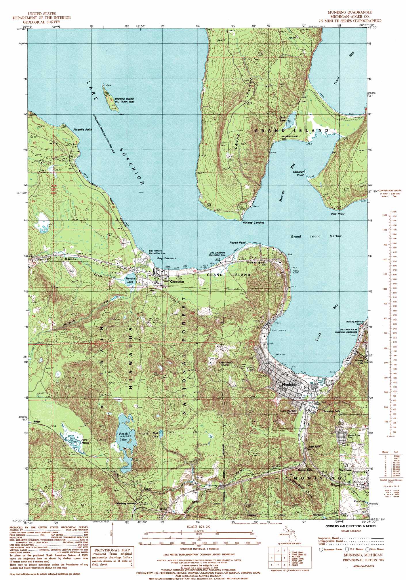
Munsing Topo Map Michigan
To zoom in, hover over the map of Munsing
USGS Topo Quad 46086d6 - 1:24,000 scale
| Topo Map Name: | Munsing |
| USGS Topo Quad ID: | 46086d6 |
| Print Size: | ca. 21 1/4" wide x 27" high |
| Southeast Coordinates: | 46.375° N latitude / 86.625° W longitude |
| Map Center Coordinates: | 46.4375° N latitude / 86.6875° W longitude |
| U.S. State: | MI |
| Filename: | o46086d6.jpg |
| Download Map JPG Image: | Munsing topo map 1:24,000 scale |
| Map Type: | Topographic |
| Topo Series: | 7.5´ |
| Map Scale: | 1:24,000 |
| Source of Map Images: | United States Geological Survey (USGS) |
| Alternate Map Versions: |
Munising MI 1985, updated 1985 Download PDF Buy paper map Munising MI 2011 Download PDF Buy paper map Munising MI 2014 Download PDF Buy paper map Munising MI 2017 Download PDF Buy paper map |
| FStopo: | US Forest Service topo Munising is available: Download FStopo PDF Download FStopo TIF |
1:24,000 Topo Quads surrounding Munsing
Laughing Fish Point |
Wood Island |
Wood Island Se |
Grand Portal Point |
|
Rock River |
Au Train |
Munsing |
Indian Town |
Melstrand |
Chatham |
Forest Lake |
Powell Lake |
Juniper |
Shingleton |
Trenary |
Lake Stella |
The Lake |
Corner Lake |
Steuben |
> Back to 46086a1 at 1:100,000 scale
> Back to 46086a1 at 1:250,000 scale
> Back to U.S. Topo Maps home
Munsing topo map: Gazetteer
Munsing: Bays
Bay Furnace elevation 184m 603′Grand Island Harbor Bay elevation 184m 603′
Murray Bay elevation 184m 603′
South Bay elevation 184m 603′
Trout Bay elevation 184m 603′
Munsing: Capes
Fivemile Point elevation 189m 620′Muskrat Point elevation 191m 626′
Powell Point elevation 184m 603′
Wick Point elevation 194m 636′
Munsing: Falls
Alger Falls elevation 208m 682′Alger Falls elevation 217m 711′
Horseshoe Falls elevation 214m 702′
Memorial Falls elevation 223m 731′
Tannery Falls elevation 228m 748′
Wagner Falls elevation 217m 711′
Munsing: Islands
Williams Island elevation 186m 610′Munsing: Lakes
Anna Marsh elevation 256m 839′Duck Lake elevation 191m 626′
Furnace Lake elevation 188m 616′
Mud Lake elevation 229m 751′
Perch Lake elevation 256m 839′
Munsing: Parks
Lobb House Historical Marker (historical) elevation 193m 633′Munsing: Populated Places
Christmas elevation 190m 623′Island View Estates Mobile Park elevation 188m 616′
Munising elevation 187m 613′
Munising Junction elevation 244m 800′
Williams Landing elevation 184m 603′
Munsing: Post Offices
Gogarnville Post Office (historical) elevation 188m 616′Hallston Post Office (historical) elevation 217m 711′
Munising Post Office elevation 191m 626′
Munsing: Streams
Anna River elevation 184m 603′Fish Hatchery Creek elevation 195m 639′
Gongeau Creek elevation 184m 603′
Hanson Creek elevation 188m 616′
Munising Falls Creek elevation 185m 606′
Tannery Creek elevation 187m 613′
Valley Spur Creek elevation 214m 702′
Wagner Creek elevation 194m 636′
Munsing digital topo map on disk
Buy this Munsing topo map showing relief, roads, GPS coordinates and other geographical features, as a high-resolution digital map file on DVD: