Au Sable Point Se Topo Map Michigan
To zoom in, hover over the map of Au Sable Point Se
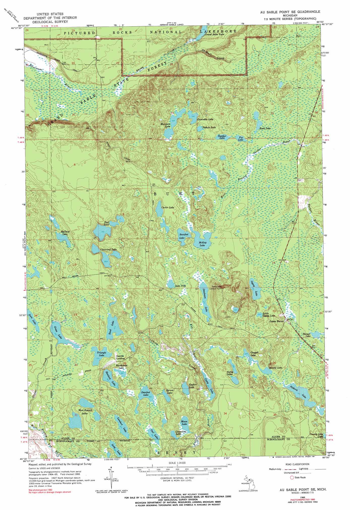
USGS Topo Quad 46086e1 - 1:24,000 scale
| Topo Map Name: | Au Sable Point Se |
| USGS Topo Quad ID: | 46086e1 |
| Print Size: | ca. 21 1/4" wide x 27" high |
| Southeast Coordinates: | 46.5° N latitude / 86° W longitude |
| Map Center Coordinates: | 46.5625° N latitude / 86.0625° W longitude |
| U.S. State: | MI |
| Filename: | o46086e1.jpg |
| Download Map JPG Image: | Au Sable Point Se topo map 1:24,000 scale |
| Map Type: | Topographic |
| Topo Series: | 7.5´ |
| Map Scale: | 1:24,000 |
| Source of Map Images: | United States Geological Survey (USGS) |
| Alternate Map Versions: |
Au Sable Point SE MI 1966, updated 1968 Download PDF Buy paper map Au Sable Point SE MI 1966, updated 1991 Download PDF Buy paper map Au Sable Point SE MI 2011 Download PDF Buy paper map Au Sable Point SE MI 2014 Download PDF Buy paper map Au Sable Point SE MI 2017 Download PDF Buy paper map |
1:24,000 Topo Quads surrounding Au Sable Point Se
Au Sable Point |
Grand Sable Lake |
Grand Marais |
Grand Marais Ne |
|
Trappers Lake |
Au Sable Point Sw |
Au Sable Point Se |
Nawakwa Lake |
Grand Marais Se |
Cusino |
Driggs Lake |
Sunken Lake |
Seney Nw |
Tahquamenon Lakes |
Creighton |
Walsh |
Driggs Lake Se |
Seney |
Hardwood Island |
> Back to 46086e1 at 1:100,000 scale
> Back to 46086a1 at 1:250,000 scale
> Back to U.S. Topo Maps home
Au Sable Point Se topo map: Gazetteer
Au Sable Point Se: Lakes
Bearfoot Lake elevation 281m 921′Buck Lake elevation 281m 921′
Carter Lake elevation 284m 931′
Casey Lake elevation 263m 862′
Centerline Lake elevation 260m 853′
Claypit Lake elevation 266m 872′
Cloverleaf Lake elevation 285m 935′
County Line Lake elevation 270m 885′
Deadman Lake elevation 281m 921′
Deerfoot Lake elevation 262m 859′
Fox Lake elevation 281m 921′
Gopher Lake elevation 266m 872′
Grass Lake elevation 272m 892′
Gypsy Lake elevation 281m 921′
Hemlock Lake elevation 266m 872′
Lake Nita elevation 281m 921′
Lambert Lake elevation 266m 872′
Lavender Lake elevation 284m 931′
Little Gypsy Lake elevation 284m 931′
Long Lake elevation 263m 862′
Loon Lake elevation 275m 902′
Mallard Lake elevation 287m 941′
Marshman Lake elevation 272m 892′
McKay Lake elevation 281m 921′
Moccasin Lake elevation 284m 931′
Moose Lake elevation 260m 853′
Owl Lake elevation 263m 862′
Palmer Lake elevation 278m 912′
Panther Lake elevation 281m 921′
Pickerel Lake elevation 269m 882′
Porky Lakes elevation 269m 882′
Pothole Lake elevation 281m 921′
Sand Lake elevation 278m 912′
Second Lake elevation 266m 872′
Spruce Lake elevation 263m 862′
Teal Lake elevation 285m 935′
Triangle Lake elevation 275m 902′
West Branch Lakes elevation 275m 902′
Au Sable Point Se: Populated Places
Green Haven elevation 280m 918′Sunrise Landing elevation 280m 918′
Au Sable Point Se: Streams
Casey Creek elevation 264m 866′De Mull Creek elevation 226m 741′
Rhody Creek elevation 228m 748′
Au Sable Point Se digital topo map on disk
Buy this Au Sable Point Se topo map showing relief, roads, GPS coordinates and other geographical features, as a high-resolution digital map file on DVD: