Marquette Topo Map Michigan
To zoom in, hover over the map of Marquette
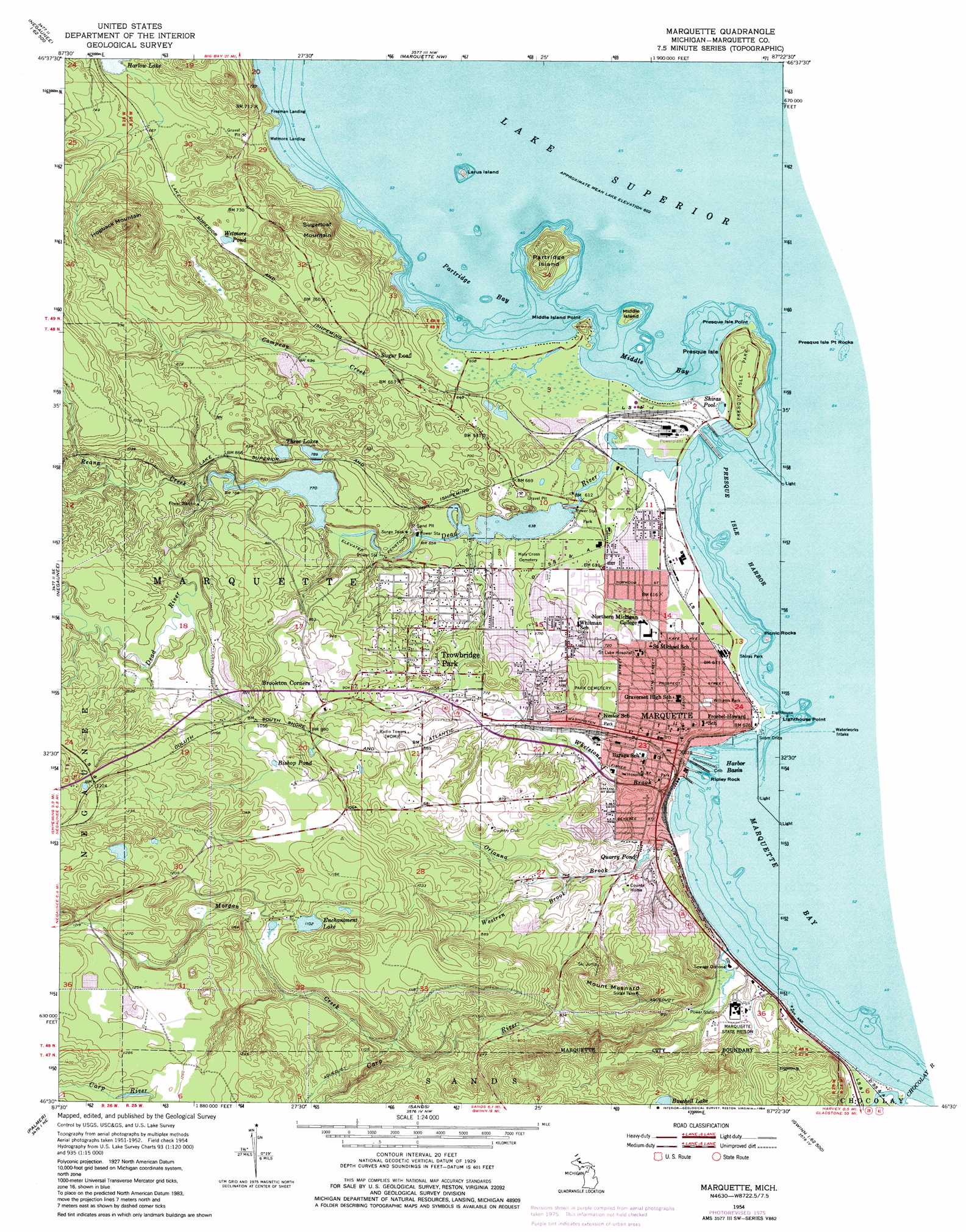
USGS Topo Quad 46087e4 - 1:24,000 scale
| Topo Map Name: | Marquette |
| USGS Topo Quad ID: | 46087e4 |
| Print Size: | ca. 21 1/4" wide x 27" high |
| Southeast Coordinates: | 46.5° N latitude / 87.375° W longitude |
| Map Center Coordinates: | 46.5625° N latitude / 87.4375° W longitude |
| U.S. State: | MI |
| Filename: | o46087e4.jpg |
| Download Map JPG Image: | Marquette topo map 1:24,000 scale |
| Map Type: | Topographic |
| Topo Series: | 7.5´ |
| Map Scale: | 1:24,000 |
| Source of Map Images: | United States Geological Survey (USGS) |
| Alternate Map Versions: |
Marquette MI 1954, updated 1955 Download PDF Buy paper map Marquette MI 1954, updated 1972 Download PDF Buy paper map Marquette MI 1954, updated 1977 Download PDF Buy paper map Marquette MI 1954, updated 1984 Download PDF Buy paper map Marquette MI 1954, updated 1984 Download PDF Buy paper map Marquette MI 2011 Download PDF Buy paper map Marquette MI 2014 Download PDF Buy paper map Marquette MI 2017 Download PDF Buy paper map |
1:24,000 Topo Quads surrounding Marquette
Big Bay |
Granite Point |
|||
Negaunee Nw |
Buckroe |
Marquette Nw |
||
Negaunee Sw |
Negaunee |
Marquette |
||
Ishpeming |
Palmer |
Sands |
Harvey |
Skandia |
Green Hills |
Cataract Basin |
Gwinn |
Little Lake |
Carlshend |
> Back to 46087e1 at 1:100,000 scale
> Back to 46086a1 at 1:250,000 scale
> Back to U.S. Topo Maps home
Marquette topo map: Gazetteer
Marquette: Bays
Marquette Bay elevation 184m 603′Middle Bay elevation 184m 603′
Partridge Bay elevation 184m 603′
Marquette: Capes
Fisherman Point elevation 184m 603′Lighthouse Point elevation 184m 603′
Middle Island Point elevation 212m 695′
Presque Isle Point elevation 184m 603′
Sunset Point elevation 186m 610′
Marquette: Falls
Dead River Falls elevation 255m 836′Holeyoke Falls elevation 292m 958′
Lower Carp River Falls elevation 300m 984′
Morgan Falls elevation 301m 987′
Reany Falls elevation 242m 793′
Marquette: Harbors
Harbor Basin elevation 184m 603′Presque Isle Harbor elevation 184m 603′
Marquette: Islands
Larus Island elevation 189m 620′Middle Island elevation 200m 656′
Partridge Island elevation 244m 800′
Picnic Rocks elevation 192m 629′
Presque Isle elevation 219m 718′
Ripley Rock elevation 184m 603′
Marquette: Lakes
Bishop Pond elevation 322m 1056′Buschell Lake elevation 296m 971′
Enchantment Lake elevation 336m 1102′
Shiras Pool elevation 186m 610′
Three Lakes elevation 240m 787′
Wetmore Pond elevation 216m 708′
Marquette: Parks
Ellwood A Mattson Lower Harbor Park elevation 190m 623′Father Marquette Park elevation 194m 636′
First Steam Railroad in Upper Peninsula Historical Marker elevation 192m 629′
Giants Foot Park elevation 252m 826′
Harlow Park elevation 215m 705′
Jacques Marquette Historical Marker elevation 195m 639′
Lakeside Park elevation 195m 639′
Lions Park elevation 230m 754′
Marquette County Courthouse Historical Marker elevation 203m 666′
McCarty Cave Park elevation 184m 603′
North Marquette Outdoor Recreation Area elevation 187m 613′
Northern Michigan University Historical Marker elevation 207m 679′
Picnic Rocks Park elevation 184m 603′
Pocket Park elevation 212m 695′
Presque Isle Park elevation 219m 718′
River Park elevation 192m 629′
Setter Field elevation 194m 636′
Shiras Hill Park elevation 222m 728′
Shiras Park elevation 184m 603′
South Beach Park elevation 184m 603′
Spring Street Park elevation 206m 675′
Tourist Park elevation 198m 649′
Williams Park elevation 207m 679′
Marquette: Populated Places
Birchgrove Mobile Home Community elevation 221m 725′Brookton Corners elevation 288m 944′
Forestville elevation 236m 774′
Freeman Landing elevation 215m 705′
Marquette elevation 203m 666′
Pioneer Estates elevation 233m 764′
Sugar Loaf elevation 206m 675′
Sunnyside Estates Community elevation 229m 751′
Trowbridge Park elevation 241m 790′
Wetmore Landing elevation 192m 629′
Marquette: Post Offices
Marquette Post Office elevation 206m 675′Marquette: Reservoirs
Quarry Pond elevation 198m 649′Marquette: Streams
Carp River elevation 183m 600′Compeau Creek elevation 186m 610′
Dead River elevation 184m 603′
Holyoke Creek elevation 279m 915′
Midway Creek elevation 297m 974′
Morgan Creek elevation 279m 915′
Orianna Brook elevation 184m 603′
Reany Creek elevation 242m 793′
Westren Brook elevation 225m 738′
Whetstone Brook elevation 184m 603′
Marquette: Summits
Hogback Mountain elevation 372m 1220′Mount Mesnard elevation 337m 1105′
Sugarloaf Mountain elevation 317m 1040′
Marquette digital topo map on disk
Buy this Marquette topo map showing relief, roads, GPS coordinates and other geographical features, as a high-resolution digital map file on DVD: