Fortune Lakes Topo Map Michigan
To zoom in, hover over the map of Fortune Lakes
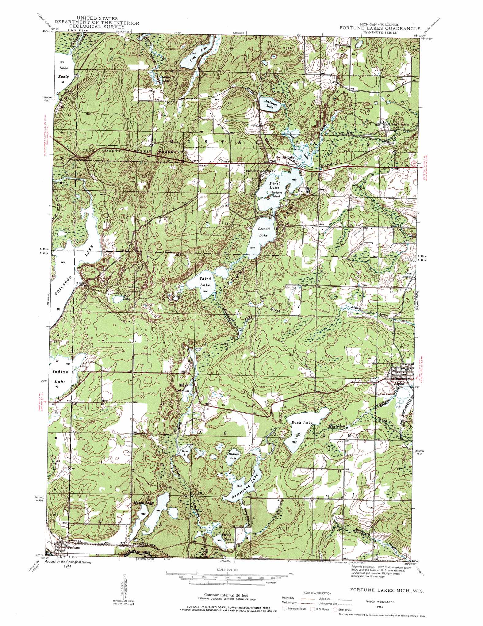
USGS Topo Quad 46088a4 - 1:24,000 scale
| Topo Map Name: | Fortune Lakes |
| USGS Topo Quad ID: | 46088a4 |
| Print Size: | ca. 21 1/4" wide x 27" high |
| Southeast Coordinates: | 46° N latitude / 88.375° W longitude |
| Map Center Coordinates: | 46.0625° N latitude / 88.4375° W longitude |
| U.S. States: | MI, WI |
| Filename: | o46088a4.jpg |
| Download Map JPG Image: | Fortune Lakes topo map 1:24,000 scale |
| Map Type: | Topographic |
| Topo Series: | 7.5´ |
| Map Scale: | 1:24,000 |
| Source of Map Images: | United States Geological Survey (USGS) |
| Alternate Map Versions: |
Fortune Lakes MI 1944, updated 1958 Download PDF Buy paper map Fortune Lakes MI 1944, updated 1978 Download PDF Buy paper map Fortune Lakes MI 2011 Download PDF Buy paper map Fortune Lakes MI 2014 Download PDF Buy paper map Fortune Lakes MI 2016 Download PDF Buy paper map |
1:24,000 Topo Quads surrounding Fortune Lakes
Perch Lake |
Porter Lake |
Triangle Ranch |
Neo Lake Se |
Hickman Lake |
Gibbs City |
Sunset Lake |
Amasa |
Kelso Junction |
Kiernan |
Iron River |
Gaastra |
Fortune Lakes |
Crystal Falls |
Lake Mary |
Tipler |
Long Lake Ne |
Naults |
Florence West |
Florence East |
Long Lake |
Long Lake Se |
Florence Sw |
Florence Se |
Iron Mountain Sw |
> Back to 46088a1 at 1:100,000 scale
> Back to 46088a1 at 1:250,000 scale
> Back to U.S. Topo Maps home
Fortune Lakes topo map: Gazetteer
Fortune Lakes: Islands
Scaddens Island elevation 418m 1371′Fortune Lakes: Lakes
Anderson Lake elevation 418m 1371′Armstrong Lake elevation 411m 1348′
Blue Lake elevation 412m 1351′
Buck Lake elevation 416m 1364′
Dam Lake elevation 405m 1328′
First Lake elevation 416m 1364′
Fortune Lakes elevation 416m 1364′
Gravel Pit Lake elevation 441m 1446′
Indian Lake elevation 433m 1420′
Isaacson Lake elevation 411m 1348′
Lake IHM elevation 402m 1318′
Long Lake elevation 432m 1417′
Maggie Lakes elevation 410m 1345′
Mud Lake elevation 418m 1371′
Pin Lake elevation 435m 1427′
Second Lake elevation 416m 1364′
Third Lake elevation 416m 1364′
Fortune Lakes: Parks
Bewabic Park elevation 427m 1400′Iron County Forest Preserve elevation 453m 1486′
Fortune Lakes: Populated Places
Alpha elevation 434m 1423′Fortune Lake elevation 417m 1368′
New Bristol Location elevation 421m 1381′
Pentoga elevation 429m 1407′
Fortune Lakes: Post Offices
Alpha Post Office elevation 455m 1492′Pentoga Post Office (historical) elevation 430m 1410′
Fortune Lakes: Streams
Alpha Creek elevation 420m 1377′Fortune Lake Creek elevation 416m 1364′
Mastodon Creek elevation 421m 1381′
Fortune Lakes digital topo map on disk
Buy this Fortune Lakes topo map showing relief, roads, GPS coordinates and other geographical features, as a high-resolution digital map file on DVD: