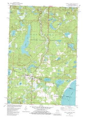
Land O' Lakes Topo Map Michigan
To zoom in, hover over the map of Land O' Lakes
USGS Topo Quad 46089b2 - 1:24,000 scale
| Topo Map Name: | Land O' Lakes |
| USGS Topo Quad ID: | 46089b2 |
| Print Size: | ca. 21 1/4" wide x 27" high |
| Southeast Coordinates: | 46.125° N latitude / 89.125° W longitude |
| Map Center Coordinates: | 46.1875° N latitude / 89.1875° W longitude |
| U.S. States: | MI, WI |
| Filename: | o46089b2.jpg |
| Download Map JPG Image: | Land O' Lakes topo map 1:24,000 scale |
| Map Type: | Topographic |
| Topo Series: | 7.5´ |
| Map Scale: | 1:24,000 |
| Source of Map Images: | United States Geological Survey (USGS) |
| Alternate Map Versions: |
Land O'Lakes WI 1982, updated 1982 Download PDF Buy paper map Land O'Lakes WI 1999, updated 2005 Download PDF Buy paper map Land O' Lakes WI 2011 Download PDF Buy paper map Land O' Lakes WI 2013 Download PDF Buy paper map Land O' Lakes WI 2015 Download PDF Buy paper map |
| FStopo: | US Forest Service topo Land O' Lakes is available: Download FStopo PDF Download FStopo TIF |
1:24,000 Topo Quads surrounding Land O' Lakes
> Back to 46089a1 at 1:100,000 scale
> Back to 46088a1 at 1:250,000 scale
> Back to U.S. Topo Maps home
Land O' Lakes topo map: Gazetteer
Land O' Lakes: Airports
Kings Land O' Lakes Airport elevation 518m 1699′Land O' Lakes: Islands
Reimers Island elevation 519m 1702′Land O' Lakes: Lakes
Allen Lake elevation 526m 1725′Anderson Lake elevation 513m 1683′
Beaver Dam Lake elevation 497m 1630′
Beaver Station Lake elevation 522m 1712′
Bee Lake elevation 519m 1702′
Birch Lake elevation 515m 1689′
Chickadee Lake elevation 530m 1738′
Crystal Lake elevation 510m 1673′
Curve Lake elevation 510m 1673′
Davis Lake elevation 520m 1706′
Dellies Lake elevation 520m 1706′
Devils Head Lake elevation 525m 1722′
Dinner Lake elevation 513m 1683′
Drone Lake elevation 521m 1709′
Duck Lake elevation 519m 1702′
Dwarf Lake elevation 518m 1699′
Eagle Lake elevation 518m 1699′
Eleanore Lake elevation 517m 1696′
Fleury Lake elevation 518m 1699′
Gateway Lake elevation 518m 1699′
Grass Lake elevation 519m 1702′
Gudegast Lake elevation 518m 1699′
Hilltop Lake elevation 543m 1781′
Hogala Lake elevation 518m 1699′
Hoist Lake elevation 518m 1699′
Honey Lake elevation 520m 1706′
Jennings Lake elevation 524m 1719′
Kvidera Lake elevation 527m 1729′
Little Duck Lake elevation 538m 1765′
Little Moon Lake elevation 519m 1702′
Little Trail Lake elevation 539m 1768′
Lumberjack Lake elevation 519m 1702′
Marsh Lake elevation 523m 1715′
Marsh Lake elevation 517m 1696′
Mill Lake elevation 516m 1692′
Moon Lake elevation 518m 1699′
Opal Lake elevation 511m 1676′
Perch Lake elevation 514m 1686′
Pilot Lake elevation 522m 1712′
Pinkeye Lake elevation 510m 1673′
Rickles Lake elevation 533m 1748′
Scout Lake elevation 518m 1699′
Shadow Lake elevation 528m 1732′
Sharptail Lake elevation 520m 1706′
Trail Lake elevation 516m 1692′
Twist Lake elevation 518m 1699′
Wilson Lake elevation 525m 1722′
Wilson Springs elevation 525m 1722′
Land O' Lakes: Populated Places
Land O' Lakes elevation 519m 1702′Land O' Lakes: Streams
Forty Five Creek elevation 508m 1666′Land O' Lakes digital topo map on disk
Buy this Land O' Lakes topo map showing relief, roads, GPS coordinates and other geographical features, as a high-resolution digital map file on DVD:


