Black Oak Lake Topo Map Michigan
To zoom in, hover over the map of Black Oak Lake
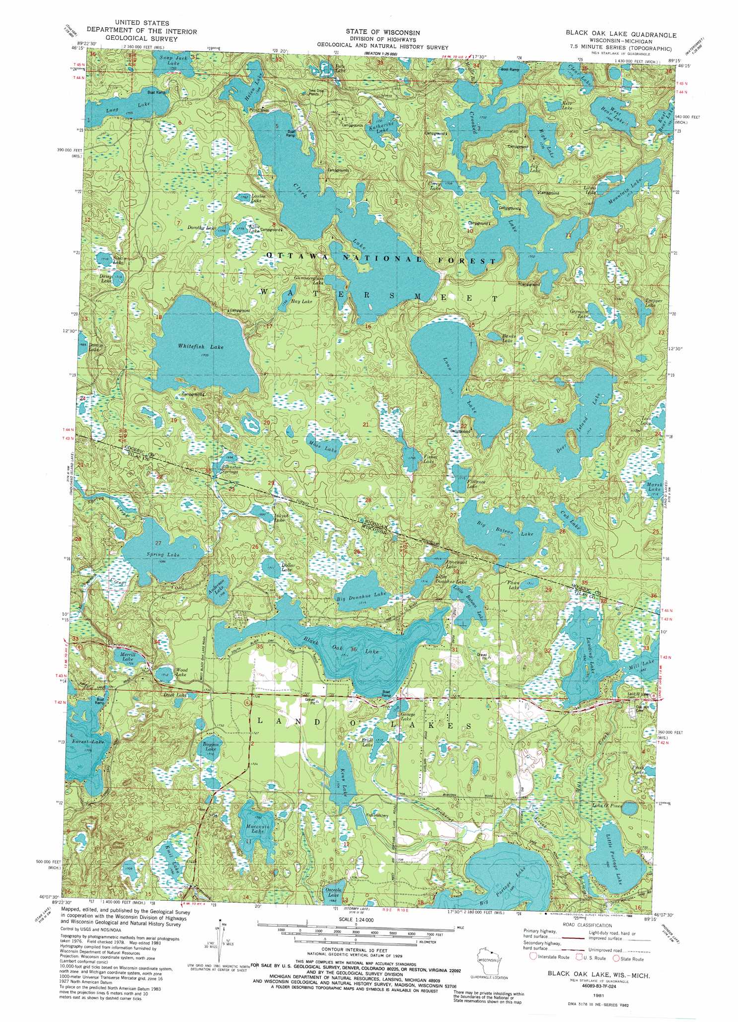
USGS Topo Quad 46089b3 - 1:24,000 scale
| Topo Map Name: | Black Oak Lake |
| USGS Topo Quad ID: | 46089b3 |
| Print Size: | ca. 21 1/4" wide x 27" high |
| Southeast Coordinates: | 46.125° N latitude / 89.25° W longitude |
| Map Center Coordinates: | 46.1875° N latitude / 89.3125° W longitude |
| U.S. States: | MI, WI |
| Filename: | o46089b3.jpg |
| Download Map JPG Image: | Black Oak Lake topo map 1:24,000 scale |
| Map Type: | Topographic |
| Topo Series: | 7.5´ |
| Map Scale: | 1:24,000 |
| Source of Map Images: | United States Geological Survey (USGS) |
| Alternate Map Versions: |
Black Oak Lake WI 1981, updated 1982 Download PDF Buy paper map Black Oak Lake WI 1981, updated 1988 Download PDF Buy paper map Black Oak Lake WI 1999, updated 2005 Download PDF Buy paper map Black Oak Lake WI 2011 Download PDF Buy paper map Black Oak Lake WI 2013 Download PDF Buy paper map Black Oak Lake WI 2015 Download PDF Buy paper map |
| FStopo: | US Forest Service topo Black Oak Lake is available: Download FStopo PDF Download FStopo TIF |
1:24,000 Topo Quads surrounding Black Oak Lake
Marshall Creek |
Cup Lake |
Choate |
Paulding |
Trout Creek |
Gogebic |
Thayer |
Beaton |
Watersmeet |
Fuller |
Tenderfoot Lake |
Thousand Island Lake |
Black Oak Lake |
Land O' Lakes |
Imp Lake |
White Sand Lake |
Star Lake |
Stormy Lake |
Pioneer Lake |
Phelps |
Sayner |
Saint Germain |
Eagle River West |
Eagle River East |
Anvil Lake |
> Back to 46089a1 at 1:100,000 scale
> Back to 46088a1 at 1:250,000 scale
> Back to U.S. Topo Maps home
Black Oak Lake topo map: Gazetteer
Black Oak Lake: Dams
Kenu Lake 2WP941 Dam elevation 519m 1702′Black Oak Lake: Lakes
Anderson Lake elevation 524m 1719′Banks Lake elevation 525m 1722′
Big Bateau Lake elevation 524m 1719′
Big Donahue Lake elevation 522m 1712′
Black Oak Lake elevation 521m 1709′
Boygan Lake elevation 531m 1742′
Clark Lake elevation 522m 1712′
Clear Lake elevation 528m 1732′
Corey Lake elevation 527m 1729′
Crooked Lake elevation 519m 1702′
Cub Lake elevation 522m 1712′
Daisy Lake elevation 521m 1709′
Deer Island Lake elevation 525m 1722′
Dollar Lake elevation 523m 1715′
Dorothy Lake elevation 542m 1778′
Duck Lake elevation 522m 1712′
East Bear Lake elevation 515m 1689′
Elsie Lake elevation 542m 1778′
Emil Lake elevation 518m 1699′
Ethel Lake elevation 523m 1715′
Fawn Lake elevation 521m 1709′
Fisher Lake elevation 532m 1745′
Florence Lake elevation 523m 1715′
George Lake elevation 521m 1709′
Germain Lake elevation 535m 1755′
Glimmerglass Lake elevation 522m 1712′
Hay Lake elevation 535m 1755′
Helen Lake elevation 528m 1732′
High Lake elevation 524m 1719′
Honey Lake elevation 518m 1699′
Inkpot Lake elevation 517m 1696′
Jay Lake elevation 544m 1784′
Johnston Springs elevation 517m 1696′
Katherine Lake elevation 548m 1797′
Kenu Lake elevation 519m 1702′
Kerr Lake elevation 519m 1702′
Lake Elaine elevation 522m 1712′
Lake O' Pines elevation 514m 1686′
Landing Lake elevation 516m 1692′
Liluis Lake elevation 523m 1715′
Little Bateau Lake elevation 521m 1709′
Little Donahue Lake elevation 522m 1712′
Little Portage Lake elevation 506m 1660′
Lois Lake elevation 524m 1719′
Long Lake elevation 535m 1755′
Loon Lake elevation 523m 1715′
Louise Lake elevation 538m 1765′
Merrill Lake elevation 532m 1745′
Moccasin Lake elevation 523m 1715′
Moss Lake elevation 535m 1755′
Mountain Lake elevation 523m 1715′
Osceola Lake elevation 513m 1683′
Pats Lake elevation 528m 1732′
Siskin Lake elevation 521m 1709′
Snap Jack Lake elevation 535m 1755′
Spring Lake elevation 514m 1686′
Trapper Lake elevation 551m 1807′
West Bear Lake elevation 517m 1696′
Whitefish Lake elevation 519m 1702′
Wood Lake elevation 533m 1748′
Black Oak Lake: Reservoirs
Kenu Lake 0.6 elevation 519m 1702′Black Oak Lake: Streams
Mill Creek elevation 506m 1660′Pickerel Creek elevation 509m 1669′
Black Oak Lake digital topo map on disk
Buy this Black Oak Lake topo map showing relief, roads, GPS coordinates and other geographical features, as a high-resolution digital map file on DVD: