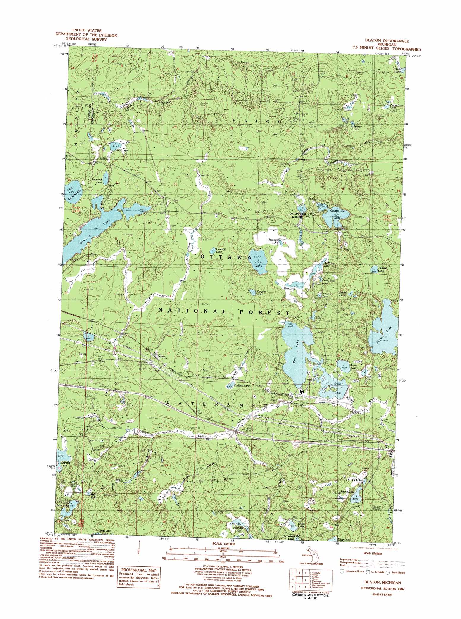
Beaton Topo Map Michigan
To zoom in, hover over the map of Beaton
USGS Topo Quad 46089c3 - 1:25,000 scale
| Topo Map Name: | Beaton |
| USGS Topo Quad ID: | 46089c3 |
| Print Size: | ca. 21 1/4" wide x 27" high |
| Southeast Coordinates: | 46.25° N latitude / 89.25° W longitude |
| Map Center Coordinates: | 46.3125° N latitude / 89.3125° W longitude |
| U.S. State: | MI |
| Filename: | l46089c3.jpg |
| Download Map JPG Image: | Beaton topo map 1:25,000 scale |
| Map Type: | Topographic |
| Topo Series: | 7.5´ |
| Map Scale: | 1:25,000 |
| Source of Map Images: | United States Geological Survey (USGS) |
| Alternate Map Versions: |
Beaton MI 1982, updated 1983 Download PDF Buy paper map |
| FStopo: | US Forest Service topo Beaton is available: Download FStopo PDF Download FStopo TIF |
1:24,000 Topo Quads surrounding Beaton
Bergland |
Matchwood |
Ewen |
Bruce Crossing |
Paynesville |
Marshall Creek |
Cup Lake |
Choate |
Paulding |
Trout Creek |
Gogebic |
Thayer |
Beaton |
Watersmeet |
Fuller |
Tenderfoot Lake |
Thousand Island Lake |
Black Oak Lake |
Land O' Lakes |
Imp Lake |
White Sand Lake |
Star Lake |
Stormy Lake |
Pioneer Lake |
Phelps |
> Back to 46089a1 at 1:100,000 scale
> Back to 46088a1 at 1:250,000 scale
> Back to U.S. Topo Maps home
Beaton topo map: Gazetteer
Beaton: Airports
Northwoods Center Conference Airport elevation 496m 1627′NRC Airport elevation 493m 1617′
Beaton: Lakes
Albino Lake elevation 505m 1656′Amik Lake elevation 493m 1617′
Beatons Lake elevation 498m 1633′
Blair Lake elevation 491m 1610′
Corssbill Lake elevation 487m 1597′
County Line Lake elevation 488m 1601′
Cowslip Lake elevation 509m 1669′
Coyote Lake elevation 504m 1653′
Crane Lake elevation 497m 1630′
Crazy Bear Lake elevation 504m 1653′
Crossbill Lake elevation 488m 1601′
Deer Lake elevation 434m 1423′
Doyle Lake elevation 533m 1748′
Hattie Lake elevation 519m 1702′
Hemlock Lake elevation 498m 1633′
Hidden Lake elevation 499m 1637′
Jaybird Lake elevation 488m 1601′
Jishib Lake elevation 496m 1627′
Joyce Lake elevation 496m 1627′
Little Beatons Lake elevation 497m 1630′
Musque Lake elevation 498m 1633′
North Line Lake elevation 443m 1453′
Ogima Lake elevation 493m 1617′
Ox Yoke Lake elevation 498m 1633′
Pan Lake elevation 499m 1637′
Partridge Lake elevation 524m 1719′
Pit Lake elevation 508m 1666′
Ross Lake elevation 524m 1719′
Spargo Lake elevation 455m 1492′
Sucker Lake elevation 492m 1614′
Whitmore Lake elevation 503m 1650′
Wolf Lake elevation 493m 1617′
Beaton: Populated Places
Beaton elevation 505m 1656′Beaton: Reservoirs
Ogima Lake elevation 493m 1617′Beaton: Streams
Blair Creek elevation 459m 1505′Cowslip Creek elevation 493m 1617′
Marathon Creek elevation 499m 1637′
Snap Jack Creek elevation 500m 1640′
Teds Creek elevation 499m 1637′
Wolf Creek elevation 489m 1604′
Beaton digital topo map on disk
Buy this Beaton topo map showing relief, roads, GPS coordinates and other geographical features, as a high-resolution digital map file on DVD: