Moose Lake Topo Map Wisconsin
To zoom in, hover over the map of Moose Lake
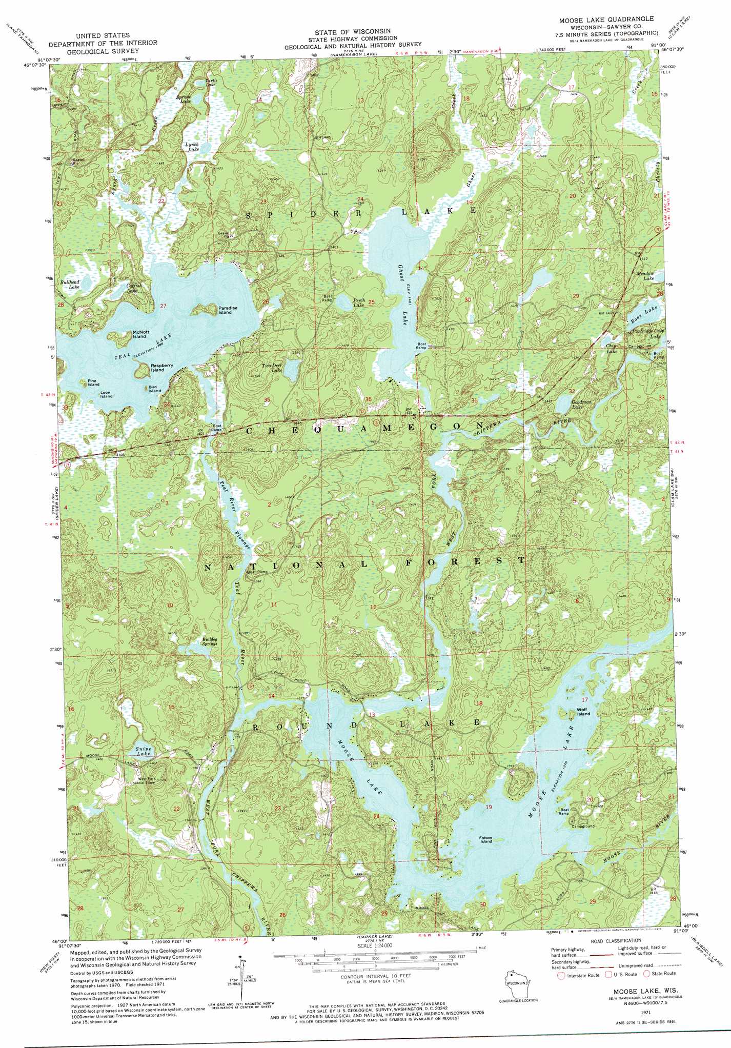
USGS Topo Quad 46091a1 - 1:24,000 scale
| Topo Map Name: | Moose Lake |
| USGS Topo Quad ID: | 46091a1 |
| Print Size: | ca. 21 1/4" wide x 27" high |
| Southeast Coordinates: | 46° N latitude / 91° W longitude |
| Map Center Coordinates: | 46.0625° N latitude / 91.0625° W longitude |
| U.S. State: | WI |
| Filename: | o46091a1.jpg |
| Download Map JPG Image: | Moose Lake topo map 1:24,000 scale |
| Map Type: | Topographic |
| Topo Series: | 7.5´ |
| Map Scale: | 1:24,000 |
| Source of Map Images: | United States Geological Survey (USGS) |
| Alternate Map Versions: |
Moose Lake WI 2005, updated 2006 Download PDF Buy paper map Moose Lake WI 2011 Download PDF Buy paper map Moose Lake WI 2013 Download PDF Buy paper map Moose Lake WI 2015 Download PDF Buy paper map |
| FStopo: | US Forest Service topo Moose Lake is available: Download FStopo PDF Download FStopo TIF |
1:24,000 Topo Quads surrounding Moose Lake
Drummond |
Diamond Lake |
Grand View |
Marengo Lake |
Mineral Lake |
Cable |
Lake Tahkodah |
Namekagon Lake |
Clam Lake |
Clam Lake Ne |
Seeley |
Spider Lake |
Moose Lake |
Clam Lake Sw |
Clam Lake Se |
Chief Lake |
New Post |
Barker Lake |
Blaisdell Lake |
Loretta |
Couderay |
Radisson |
Winter |
Lake Winter |
Babbs Island |
> Back to 46091a1 at 1:100,000 scale
> Back to 46090a1 at 1:250,000 scale
> Back to U.S. Topo Maps home
Moose Lake topo map: Gazetteer
Moose Lake: Dams
Ghost Lake WP307 Dam elevation 429m 1407′Moose Lake 1911 C640 Dam elevation 418m 1371′
West Fork Dam elevation 418m 1371′
Moose Lake: Islands
Bird Island elevation 422m 1384′Folson Island elevation 418m 1371′
Loon Island elevation 423m 1387′
McNott Island elevation 427m 1400′
Paradise Island elevation 427m 1400′
Pine Island elevation 426m 1397′
Raspberry Island elevation 429m 1407′
Wolf Island elevation 419m 1374′
Moose Lake: Lakes
Boos Lake elevation 422m 1384′Bullhead Lake elevation 425m 1394′
Catfish Lake elevation 423m 1387′
Chip Lake elevation 422m 1384′
Ghost Lake elevation 427m 1400′
Goodman Lake elevation 425m 1394′
Lynch Lake elevation 425m 1394′
Moose Lake elevation 418m 1371′
Perch Lake elevation 431m 1414′
Snipe Lake elevation 422m 1384′
Spruce Lake elevation 426m 1397′
Teal Lake elevation 422m 1384′
Teal River Flowage elevation 421m 1381′
Turtle Lake elevation 426m 1397′
Two Deer Lake elevation 431m 1414′
Moose Lake: Parks
Balsam Creek Waterfowl Area elevation 433m 1420′Moose Lake: Reservoirs
Balsam Creek Flowage elevation 431m 1414′Ghost Lake 22 elevation 429m 1407′
Moose Lake 190 elevation 418m 1371′
Moose Lake: Springs
Bulldog Springs elevation 419m 1374′Moose Lake: Streams
Ghost Creek elevation 418m 1371′Lynch Creek elevation 422m 1384′
Moose River elevation 418m 1371′
Teal River elevation 413m 1354′
Moose Lake digital topo map on disk
Buy this Moose Lake topo map showing relief, roads, GPS coordinates and other geographical features, as a high-resolution digital map file on DVD: