Spider Lake Topo Map Wisconsin
To zoom in, hover over the map of Spider Lake
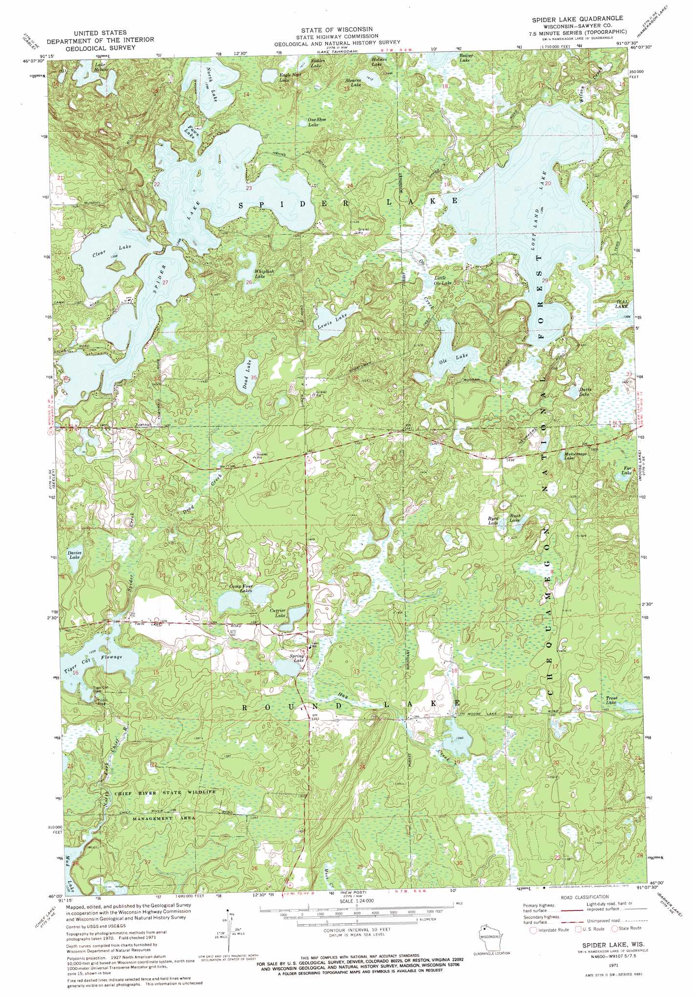
USGS Topo Quad 46091a2 - 1:24,000 scale
| Topo Map Name: | Spider Lake |
| USGS Topo Quad ID: | 46091a2 |
| Print Size: | ca. 21 1/4" wide x 27" high |
| Southeast Coordinates: | 46° N latitude / 91.125° W longitude |
| Map Center Coordinates: | 46.0625° N latitude / 91.1875° W longitude |
| U.S. State: | WI |
| Filename: | o46091a2.jpg |
| Download Map JPG Image: | Spider Lake topo map 1:24,000 scale |
| Map Type: | Topographic |
| Topo Series: | 7.5´ |
| Map Scale: | 1:24,000 |
| Source of Map Images: | United States Geological Survey (USGS) |
| Alternate Map Versions: |
Spider Lake WI 1971, updated 1973 Download PDF Buy paper map Spider Lake WI 2005, updated 2006 Download PDF Buy paper map Spider Lake WI 2011 Download PDF Buy paper map Spider Lake WI 2013 Download PDF Buy paper map Spider Lake WI 2015 Download PDF Buy paper map |
| FStopo: | US Forest Service topo Spider Lake is available: Download FStopo PDF Download FStopo TIF |
1:24,000 Topo Quads surrounding Spider Lake
Upper Eau Claire Lake |
Drummond |
Diamond Lake |
Grand View |
Marengo Lake |
Totagatic Lake |
Cable |
Lake Tahkodah |
Namekagon Lake |
Clam Lake |
Hayward |
Seeley |
Spider Lake |
Moose Lake |
Clam Lake Sw |
Reserve |
Chief Lake |
New Post |
Barker Lake |
Blaisdell Lake |
Hauer |
Couderay |
Radisson |
Winter |
Lake Winter |
> Back to 46091a1 at 1:100,000 scale
> Back to 46090a1 at 1:250,000 scale
> Back to U.S. Topo Maps home
Spider Lake topo map: Gazetteer
Spider Lake: Dams
Tiger Cat 2WP255 Dam elevation 409m 1341′Tiger Cat Dam elevation 415m 1361′
Spider Lake: Lakes
Byrd Lake elevation 428m 1404′Camp Four Lakes elevation 421m 1381′
Clear Lake elevation 424m 1391′
Currier Lake elevation 421m 1381′
Davies Lake elevation 415m 1361′
Davis Lake elevation 424m 1391′
Dead Lake elevation 424m 1391′
Eagle Nest Lake elevation 427m 1400′
Fawn Lake elevation 424m 1391′
Foo Lake elevation 427m 1400′
Lake Helane elevation 424m 1391′
Larson Lake elevation 428m 1404′
Lewis Lake elevation 424m 1391′
Little Ole Lake elevation 424m 1391′
Lost Land Lake elevation 421m 1381′
Mukwonago Lake elevation 428m 1404′
North Lake elevation 424m 1391′
Ole Lake elevation 421m 1381′
One Shoe Lake elevation 428m 1404′
Rush Lake elevation 429m 1407′
Sickles Lake elevation 430m 1410′
Spider Lake elevation 424m 1391′
Spring Lake elevation 418m 1371′
Stearns Lake elevation 430m 1410′
Trout Lake elevation 427m 1400′
Whiplash Lake elevation 427m 1400′
Spider Lake: Parks
Chief River State Wildlife Management Area elevation 416m 1364′Spider Lake: Reservoirs
Tiger Cat Flowage elevation 415m 1361′Tiger Cat Flowage 47 elevation 409m 1341′
Spider Lake: Springs
Dead Creek Spring elevation 424m 1391′Spider Lake: Streams
Dead Creek elevation 416m 1364′Ole Creek elevation 421m 1381′
Spider Creek elevation 420m 1377′
Wilson Creek elevation 422m 1384′
Spider Lake digital topo map on disk
Buy this Spider Lake topo map showing relief, roads, GPS coordinates and other geographical features, as a high-resolution digital map file on DVD: