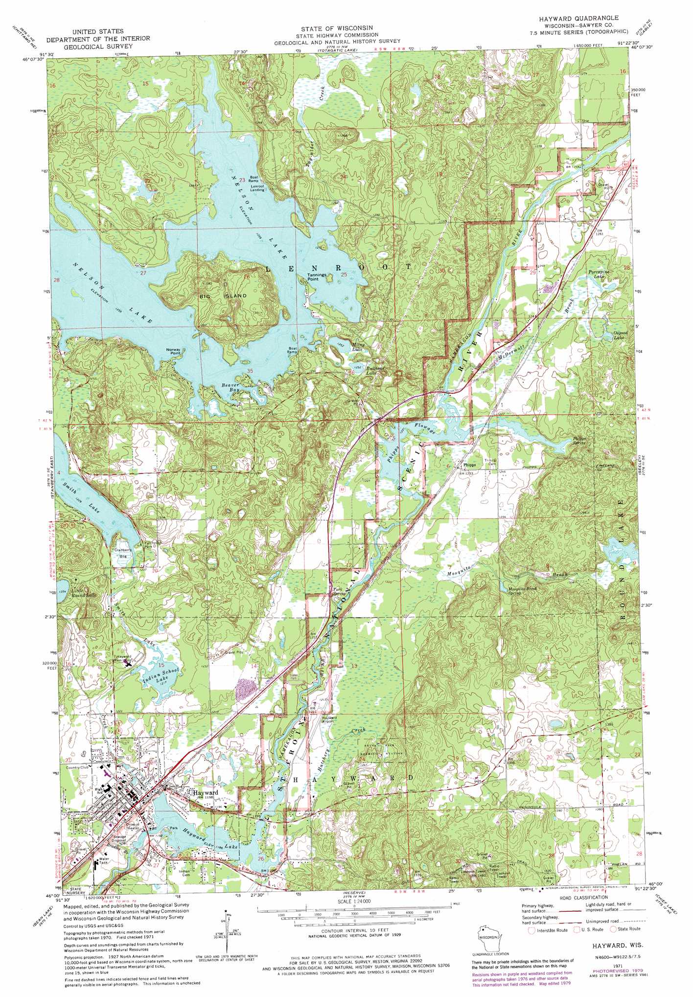
Hayward Topo Map Wisconsin
To zoom in, hover over the map of Hayward
USGS Topo Quad 46091a4 - 1:24,000 scale
| Topo Map Name: | Hayward |
| USGS Topo Quad ID: | 46091a4 |
| Print Size: | ca. 21 1/4" wide x 27" high |
| Southeast Coordinates: | 46° N latitude / 91.375° W longitude |
| Map Center Coordinates: | 46.0625° N latitude / 91.4375° W longitude |
| U.S. State: | WI |
| Filename: | o46091a4.jpg |
| Download Map JPG Image: | Hayward topo map 1:24,000 scale |
| Map Type: | Topographic |
| Topo Series: | 7.5´ |
| Map Scale: | 1:24,000 |
| Source of Map Images: | United States Geological Survey (USGS) |
| Alternate Map Versions: |
Hayward WI 1971, updated 1973 Download PDF Buy paper map Hayward WI 1971, updated 1979 Download PDF Buy paper map Hayward WI 2010 Download PDF Buy paper map Hayward WI 2013 Download PDF Buy paper map Hayward WI 2015 Download PDF Buy paper map |
1:24,000 Topo Quads surrounding Hayward
Metzger Lake |
Ellison Lake |
Upper Eau Claire Lake |
Drummond |
Diamond Lake |
Chittamo |
Chittamo Ne |
Totagatic Lake |
Cable |
Lake Tahkodah |
Stanberry West |
Stanberry East |
Hayward |
Seeley |
Spider Lake |
Springbrook |
Bean Lake |
Reserve |
Chief Lake |
New Post |
Potato Lake |
Stone Lake |
Hauer |
Couderay |
Radisson |
> Back to 46091a1 at 1:100,000 scale
> Back to 46090a1 at 1:250,000 scale
> Back to U.S. Topo Maps home
Hayward topo map: Gazetteer
Hayward: Airports
Hayward Municipal Airport elevation 369m 1210′Hayward: Bays
Beaver Bay elevation 382m 1253′Hayward: Capes
Norway Point elevation 387m 1269′Tannings Point elevation 388m 1272′
Hayward: Channels
Phipps Flowage elevation 372m 1220′Hayward: Dams
Hayward WP119 Dam elevation 360m 1181′Hayward: Islands
Big Island elevation 403m 1322′Hayward: Lakes
Bullhead Lake elevation 382m 1253′Indian School Lake elevation 369m 1210′
Little Round Lake elevation 382m 1253′
Milny Lake elevation 382m 1253′
Osgood Lake elevation 381m 1250′
Porcupine Lake elevation 380m 1246′
Shues Pond elevation 365m 1197′
Smith Lake elevation 372m 1220′
Hayward: Parks
Eytcheson Park elevation 375m 1230′Saint Croix National Scenic River elevation 380m 1246′
Hayward: Populated Places
Hayward elevation 363m 1190′Phipps elevation 375m 1230′
Hayward: Post Offices
Hayward Post Office elevation 368m 1207′Hayward: Reservoirs
Hayward Flowage 94 elevation 364m 1194′Hayward Lake elevation 360m 1181′
Hayward: Springs
Mosquito Brook Spring elevation 380m 1246′Phipps Spring elevation 372m 1220′
Turk Spring elevation 366m 1200′
Hayward: Streams
Bradley Branch elevation 359m 1177′Hatchery Creek elevation 363m 1190′
McDermott Brook elevation 375m 1230′
Mosquito Brook elevation 368m 1207′
Smith Lake Creek elevation 360m 1181′
Tag-Alder Creek elevation 384m 1259′
Hayward digital topo map on disk
Buy this Hayward topo map showing relief, roads, GPS coordinates and other geographical features, as a high-resolution digital map file on DVD: