Cable Topo Map Wisconsin
To zoom in, hover over the map of Cable
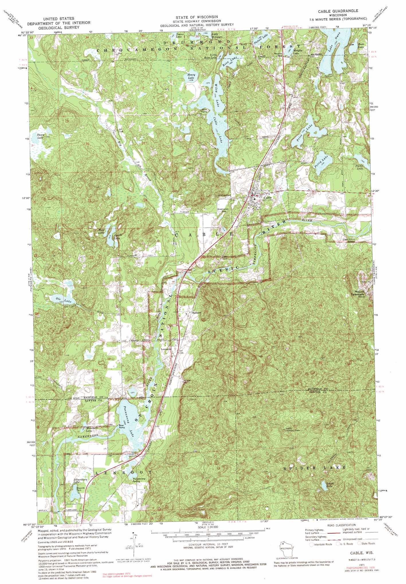
USGS Topo Quad 46091b3 - 1:24,000 scale
| Topo Map Name: | Cable |
| USGS Topo Quad ID: | 46091b3 |
| Print Size: | ca. 21 1/4" wide x 27" high |
| Southeast Coordinates: | 46.125° N latitude / 91.25° W longitude |
| Map Center Coordinates: | 46.1875° N latitude / 91.3125° W longitude |
| U.S. State: | WI |
| Filename: | o46091b3.jpg |
| Download Map JPG Image: | Cable topo map 1:24,000 scale |
| Map Type: | Topographic |
| Topo Series: | 7.5´ |
| Map Scale: | 1:24,000 |
| Source of Map Images: | United States Geological Survey (USGS) |
| Alternate Map Versions: |
Cable WI 1971, updated 1973 Download PDF Buy paper map Cable WI 1971, updated 1983 Download PDF Buy paper map Cable WI 2005, updated 2006 Download PDF Buy paper map Cable WI 2011 Download PDF Buy paper map Cable WI 2013 Download PDF Buy paper map Cable WI 2015 Download PDF Buy paper map |
| FStopo: | US Forest Service topo Cable is available: Download FStopo PDF Download FStopo TIF |
1:24,000 Topo Quads surrounding Cable
Island Lake |
Drummond Nw |
Delta |
Grandview Nw |
Mason |
Ellison Lake |
Upper Eau Claire Lake |
Drummond |
Diamond Lake |
Grand View |
Chittamo Ne |
Totagatic Lake |
Cable |
Lake Tahkodah |
Namekagon Lake |
Stanberry East |
Hayward |
Seeley |
Spider Lake |
Moose Lake |
Bean Lake |
Reserve |
Chief Lake |
New Post |
Barker Lake |
> Back to 46091a1 at 1:100,000 scale
> Back to 46090a1 at 1:250,000 scale
> Back to U.S. Topo Maps home
Cable topo map: Gazetteer
Cable: Lakes
Bass Lake elevation 410m 1345′Cable Lake elevation 419m 1374′
Dawn Lake elevation 419m 1374′
Henry Lake elevation 420m 1377′
Lake Wilipyro elevation 425m 1394′
Lerche Lake elevation 401m 1315′
Little Rosa Lake elevation 427m 1400′
Mossback Lake elevation 390m 1279′
Motyka Lake elevation 421m 1381′
Ole Lake elevation 404m 1325′
Pacwawong Lake elevation 386m 1266′
Perry Lake elevation 407m 1335′
Picture Lake elevation 422m 1384′
Porter Lakes elevation 408m 1338′
Price Lake elevation 408m 1338′
Rosa Lake elevation 421m 1381′
Silverthorn Lake elevation 386m 1266′
Smear Lake elevation 427m 1400′
Smith Lake elevation 419m 1374′
West Lake elevation 401m 1315′
Wiley Lake elevation 419m 1374′
Cable: Populated Places
Cable elevation 417m 1368′Leonards elevation 398m 1305′
Radspur elevation 400m 1312′
Cable: Springs
Pacwawong Spring elevation 386m 1266′Cable: Streams
Big Brook elevation 391m 1282′Cable: Summits
Mount Telemark elevation 461m 1512′Mount Telemark elevation 519m 1702′
Cable digital topo map on disk
Buy this Cable topo map showing relief, roads, GPS coordinates and other geographical features, as a high-resolution digital map file on DVD: