Hart Lake Topo Map Wisconsin
To zoom in, hover over the map of Hart Lake
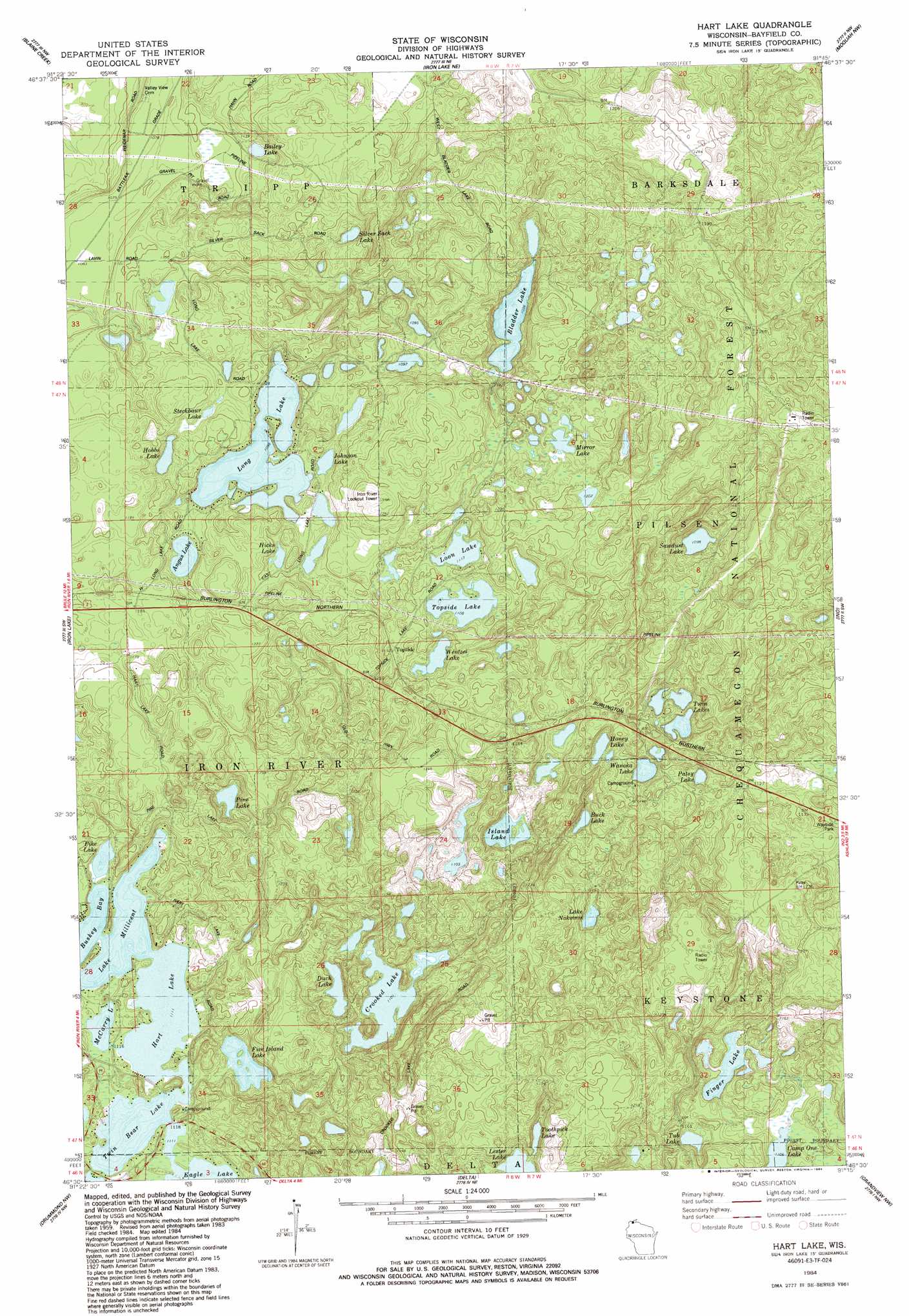
USGS Topo Quad 46091e3 - 1:24,000 scale
| Topo Map Name: | Hart Lake |
| USGS Topo Quad ID: | 46091e3 |
| Print Size: | ca. 21 1/4" wide x 27" high |
| Southeast Coordinates: | 46.5° N latitude / 91.25° W longitude |
| Map Center Coordinates: | 46.5625° N latitude / 91.3125° W longitude |
| U.S. State: | WI |
| Filename: | o46091e3.jpg |
| Download Map JPG Image: | Hart Lake topo map 1:24,000 scale |
| Map Type: | Topographic |
| Topo Series: | 7.5´ |
| Map Scale: | 1:24,000 |
| Source of Map Images: | United States Geological Survey (USGS) |
| Alternate Map Versions: |
Iron Lake SE WI 1961, updated 1985 Download PDF Buy paper map Hart Lake WI 1984, updated 1984 Download PDF Buy paper map Hart Lake WI 2005, updated 2006 Download PDF Buy paper map Hart Lake WI 2011 Download PDF Buy paper map Hart Lake WI 2013 Download PDF Buy paper map Hart Lake WI 2015 Download PDF Buy paper map |
| FStopo: | US Forest Service topo Hart Lake is available: Download FStopo PDF Download FStopo TIF |
1:24,000 Topo Quads surrounding Hart Lake
Port Wing |
Herbster |
Bark Bay |
Cornucopia |
|
Oulu |
Blaine Creek |
Iron Lake Ne |
Moquah Nw |
Mount Valhalla |
Brule |
Iron Lake |
Hart Lake |
Ino |
Moquah |
Island Lake |
Drummond Nw |
Delta |
Grandview Nw |
Mason |
Ellison Lake |
Upper Eau Claire Lake |
Drummond |
Diamond Lake |
Grand View |
> Back to 46091e1 at 1:100,000 scale
> Back to 46090a1 at 1:250,000 scale
> Back to U.S. Topo Maps home
Hart Lake topo map: Gazetteer
Hart Lake: Lakes
Angus Lake elevation 329m 1079′Bailey Lake elevation 328m 1076′
Bladder Lake elevation 332m 1089′
Buck Lake elevation 326m 1069′
Buskey Bay elevation 337m 1105′
Camp One Lake elevation 337m 1105′
Crooked Lake elevation 335m 1099′
Duck Lake elevation 335m 1099′
Finger Lake elevation 332m 1089′
Five Island Lake elevation 335m 1099′
Hart Lake elevation 337m 1105′
Hicks Lake elevation 332m 1089′
Hobbs Lake elevation 310m 1017′
Honey Lake elevation 329m 1079′
Island Lake elevation 335m 1099′
Johnson Lake elevation 317m 1040′
Lake Millicent elevation 337m 1105′
Lake Nokomis elevation 336m 1102′
Lester Lake elevation 329m 1079′
Long Lake elevation 329m 1079′
Loon Lake elevation 337m 1105′
McCarry Lake elevation 337m 1105′
Mirror Lake elevation 361m 1184′
Patsy Lake elevation 328m 1076′
Pike Lake elevation 337m 1105′
Pine Lake elevation 334m 1095′
Sawdust Lake elevation 318m 1043′
Silver Sack Lake elevation 325m 1066′
Steckbaur Lake elevation 332m 1089′
Toothpick Lake elevation 337m 1105′
Topside Lake elevation 335m 1099′
Tub Lake elevation 340m 1115′
Twin Bear Lake elevation 337m 1105′
Twin Lakes elevation 326m 1069′
Wanoka Lake elevation 331m 1085′
Wentzel Lake elevation 335m 1099′
Hart Lake: Populated Places
Topside elevation 352m 1154′Hart Lake digital topo map on disk
Buy this Hart Lake topo map showing relief, roads, GPS coordinates and other geographical features, as a high-resolution digital map file on DVD: