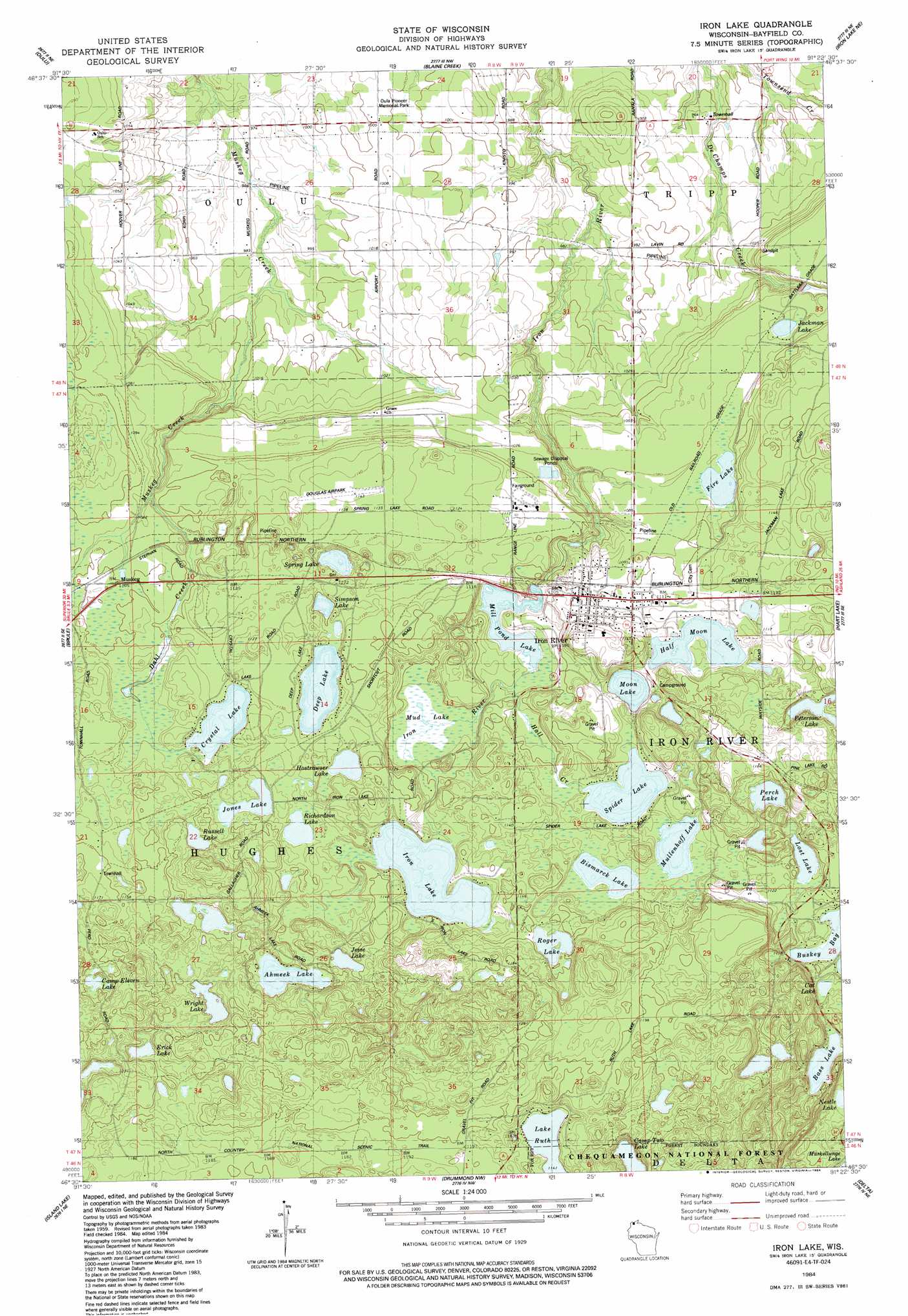
Iron Lake Topo Map Wisconsin
To zoom in, hover over the map of Iron Lake
USGS Topo Quad 46091e4 - 1:24,000 scale
| Topo Map Name: | Iron Lake |
| USGS Topo Quad ID: | 46091e4 |
| Print Size: | ca. 21 1/4" wide x 27" high |
| Southeast Coordinates: | 46.5° N latitude / 91.375° W longitude |
| Map Center Coordinates: | 46.5625° N latitude / 91.4375° W longitude |
| U.S. State: | WI |
| Filename: | o46091e4.jpg |
| Download Map JPG Image: | Iron Lake topo map 1:24,000 scale |
| Map Type: | Topographic |
| Topo Series: | 7.5´ |
| Map Scale: | 1:24,000 |
| Source of Map Images: | United States Geological Survey (USGS) |
| Alternate Map Versions: |
Iron Lake SW WI 1961 Download PDF Buy paper map Iron Lake WI 1984, updated 1984 Download PDF Buy paper map Iron Lake WI 1984, updated 1992 Download PDF Buy paper map Iron Lake WI 2005, updated 2006 Download PDF Buy paper map Iron Lake WI 2011 Download PDF Buy paper map Iron Lake WI 2013 Download PDF Buy paper map Iron Lake WI 2015 Download PDF Buy paper map |
| FStopo: | US Forest Service topo Iron Lake is available: Download FStopo PDF Download FStopo TIF |
1:24,000 Topo Quads surrounding Iron Lake
Port Wing |
Herbster |
Bark Bay |
||
Cloverland |
Oulu |
Blaine Creek |
Iron Lake Ne |
Moquah Nw |
Lake Nebagamon |
Brule |
Iron Lake |
Hart Lake |
Ino |
Lake Minnesuing |
Island Lake |
Drummond Nw |
Delta |
Grandview Nw |
Metzger Lake |
Ellison Lake |
Upper Eau Claire Lake |
Drummond |
Diamond Lake |
> Back to 46091e1 at 1:100,000 scale
> Back to 46090a1 at 1:250,000 scale
> Back to U.S. Topo Maps home
Iron Lake topo map: Gazetteer
Iron Lake: Airports
Bayfield County Airport elevation 346m 1135′Iron Lake: Dams
Iron River Light and Power Company WP182 Dam elevation 320m 1049′Iron Lake: Lakes
Ahmeek Lake elevation 346m 1135′Bass Lake elevation 340m 1115′
Bismarck Lake elevation 340m 1115′
Camp Eleven Lake elevation 362m 1187′
Cat Lake elevation 341m 1118′
Crystal Lake elevation 337m 1105′
Deep Lake elevation 337m 1105′
Erick Lake elevation 357m 1171′
Fire Lake elevation 331m 1085′
Half Moon Lake elevation 337m 1105′
Hostrawser Lake elevation 337m 1105′
Iron Lake elevation 337m 1105′
Jackman Lake elevation 328m 1076′
Jesse Lake elevation 349m 1145′
Jones Lake elevation 343m 1125′
Lake Ruth elevation 347m 1138′
Lost Lake elevation 340m 1115′
Mill Pond Lake elevation 324m 1062′
Minor Lake elevation 364m 1194′
Moon Lake elevation 334m 1095′
Mud Lake elevation 332m 1089′
Mullenhoff Lake elevation 340m 1115′
Nestle Lake elevation 338m 1108′
Perch Lake elevation 340m 1115′
Peterson Lake elevation 340m 1115′
Richardson Lake elevation 343m 1125′
Roger Lake elevation 346m 1135′
Russell Lake elevation 350m 1148′
Simpson Lake elevation 334m 1095′
Spider Lake elevation 337m 1105′
Spring Lake elevation 328m 1076′
Wright Lake elevation 349m 1145′
Iron Lake: Parks
Oula Pioneer Memorial Park elevation 305m 1000′Iron Lake: Populated Places
Iron River elevation 337m 1105′Muskeg elevation 332m 1089′
Iron Lake: Reservoirs
Iron River Flowage 8.37 elevation 320m 1049′Iron Lake: Streams
Dahl Creek elevation 330m 1082′Hall Creek elevation 328m 1076′
Iron Lake digital topo map on disk
Buy this Iron Lake topo map showing relief, roads, GPS coordinates and other geographical features, as a high-resolution digital map file on DVD: