Brule Topo Map Wisconsin
To zoom in, hover over the map of Brule
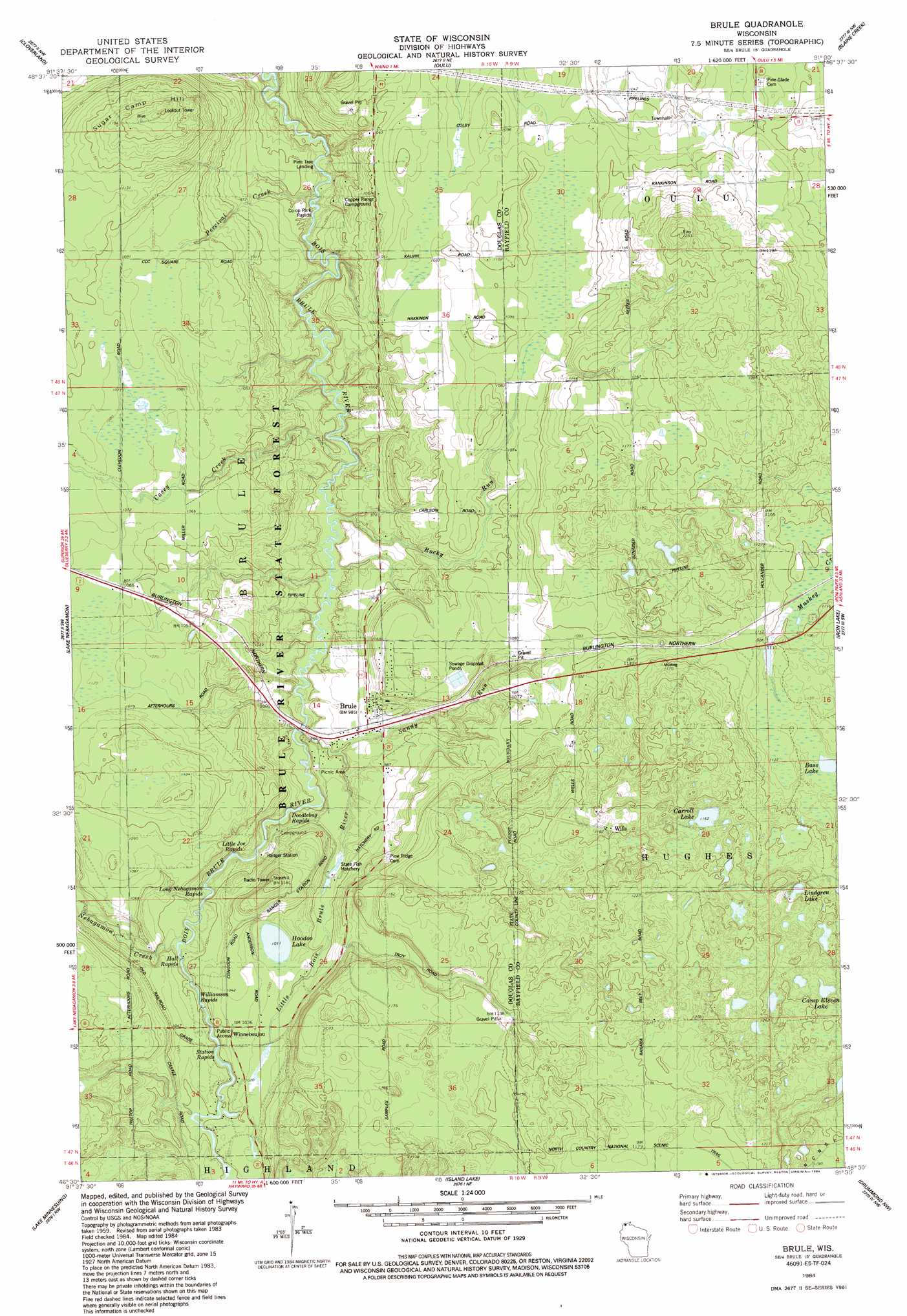
USGS Topo Quad 46091e5 - 1:24,000 scale
| Topo Map Name: | Brule |
| USGS Topo Quad ID: | 46091e5 |
| Print Size: | ca. 21 1/4" wide x 27" high |
| Southeast Coordinates: | 46.5° N latitude / 91.5° W longitude |
| Map Center Coordinates: | 46.5625° N latitude / 91.5625° W longitude |
| U.S. State: | WI |
| Filename: | o46091e5.jpg |
| Download Map JPG Image: | Brule topo map 1:24,000 scale |
| Map Type: | Topographic |
| Topo Series: | 7.5´ |
| Map Scale: | 1:24,000 |
| Source of Map Images: | United States Geological Survey (USGS) |
| Alternate Map Versions: |
Brule WI 1984, updated 1984 Download PDF Buy paper map Brule WI 2010 Download PDF Buy paper map Brule WI 2013 Download PDF Buy paper map Brule WI 2015 Download PDF Buy paper map |
1:24,000 Topo Quads surrounding Brule
Port Wing |
Herbster |
|||
Poplar Ne |
Cloverland |
Oulu |
Blaine Creek |
Iron Lake Ne |
Poplar |
Lake Nebagamon |
Brule |
Iron Lake |
Hart Lake |
Bennett |
Lake Minnesuing |
Island Lake |
Drummond Nw |
Delta |
Solon Springs |
Metzger Lake |
Ellison Lake |
Upper Eau Claire Lake |
Drummond |
> Back to 46091e1 at 1:100,000 scale
> Back to 46090a1 at 1:250,000 scale
> Back to U.S. Topo Maps home
Brule topo map: Gazetteer
Brule: Lakes
Bass Lake elevation 340m 1115′Camp Eleven Lake elevation 370m 1213′
Carroll Lake elevation 355m 1164′
Hoodoo Lake elevation 308m 1010′
Lindgren Lake elevation 367m 1204′
Brule: Populated Places
Brule elevation 301m 987′Wills elevation 354m 1161′
Winneboujou elevation 313m 1026′
Brule: Rapids
Co-op Park Rapids elevation 277m 908′Doodlebug Rapids elevation 289m 948′
Hall Rapids elevation 301m 987′
Little Joe Rapids elevation 291m 954′
Long Nebagamon Rapids elevation 295m 967′
Station Rapids elevation 301m 987′
Williamson Rapids elevation 300m 984′
Brule: Streams
Casey Creek elevation 286m 938′Little Bois Brule River elevation 287m 941′
Nebagamon Creek elevation 301m 987′
Percival Creek elevation 289m 948′
Rocky Run elevation 284m 931′
Sandy Run elevation 293m 961′
Brule: Summits
Sugar Camp Hill elevation 369m 1210′Brule digital topo map on disk
Buy this Brule topo map showing relief, roads, GPS coordinates and other geographical features, as a high-resolution digital map file on DVD: