Duluth Topo Map Minnesota
To zoom in, hover over the map of Duluth
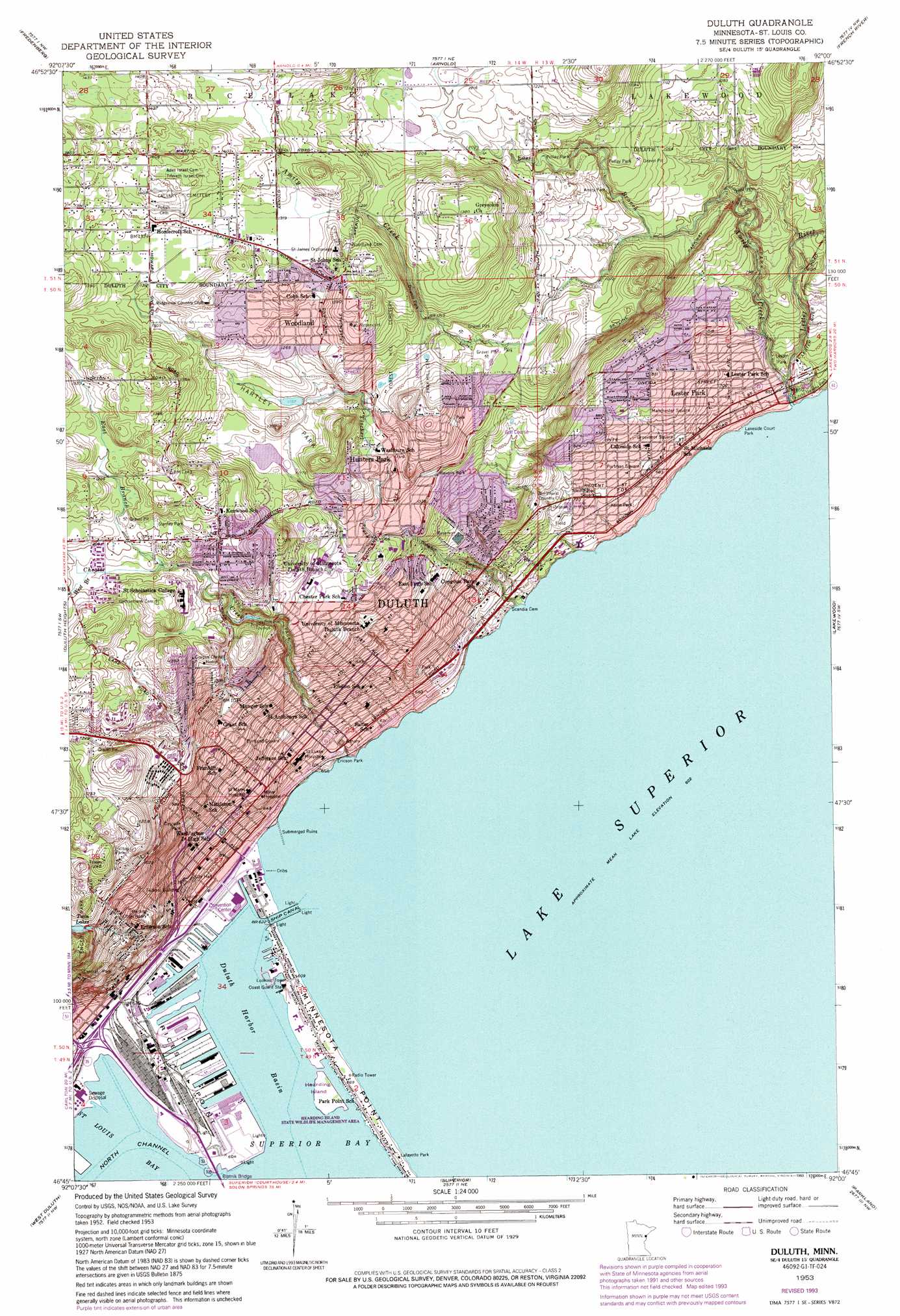
USGS Topo Quad 46092g1 - 1:24,000 scale
| Topo Map Name: | Duluth |
| USGS Topo Quad ID: | 46092g1 |
| Print Size: | ca. 21 1/4" wide x 27" high |
| Southeast Coordinates: | 46.75° N latitude / 92° W longitude |
| Map Center Coordinates: | 46.8125° N latitude / 92.0625° W longitude |
| U.S. State: | MN |
| Filename: | o46092g1.jpg |
| Download Map JPG Image: | Duluth topo map 1:24,000 scale |
| Map Type: | Topographic |
| Topo Series: | 7.5´ |
| Map Scale: | 1:24,000 |
| Source of Map Images: | United States Geological Survey (USGS) |
| Alternate Map Versions: |
Duluth MN 1953, updated 1955 Download PDF Buy paper map Duluth MN 1953, updated 1965 Download PDF Buy paper map Duluth MN 1953, updated 1970 Download PDF Buy paper map Duluth MN 1953, updated 1973 Download PDF Buy paper map Duluth MN 1953, updated 1976 Download PDF Buy paper map Duluth MN 1953, updated 1987 Download PDF Buy paper map Duluth MN 1953, updated 1993 Download PDF Buy paper map Duluth MN 2010 Download PDF Buy paper map Duluth MN 2013 Download PDF Buy paper map Duluth MN 2016 Download PDF Buy paper map |
1:24,000 Topo Quads surrounding Duluth
Shaw |
Boulder Lake Reservoir |
Thompson Lake |
Barrs Lake |
Mccarthy Creek |
Twig |
Fredenberg |
Arnold |
French River |
Knife River |
Adolph |
Duluth Heights |
Duluth |
Lakewood |
|
Esko |
West Duluth |
Superior |
Parkland |
Poplar Ne |
Frogner |
Borea |
Sunnyside |
South Range |
Poplar |
> Back to 46092e1 at 1:100,000 scale
> Back to 46092a1 at 1:250,000 scale
> Back to U.S. Topo Maps home
Duluth topo map: Gazetteer
Duluth: Airports
Saint Luke Hospital Heliport elevation 207m 679′Saint Marys Hospital Heliport elevation 242m 793′
Duluth: Bays
Duluth Harbor Basin elevation 183m 600′Duluth Harbor Basin Northern Section elevation 183m 600′
Duluth Harbor Basin Southern Section elevation 183m 600′
Saint Louis Bay elevation 183m 600′
Saint Louis Bay elevation 183m 600′
Duluth: Bridges
Aerial Lift Bridge elevation 183m 600′Blatnik Bridge elevation 184m 603′
Lester Bridge elevation 187m 613′
Minnesota Slip Bridge elevation 184m 603′
Minnesota Slip Drawbridge elevation 184m 603′
Duluth: Canals
Duluth Entry elevation 183m 600′Duluth: Capes
Rices Point elevation 184m 603′Duluth: Dams
Hartley Pond Dam elevation 366m 1200′Duluth: Islands
Hearding Island elevation 184m 603′Duluth: Lakes
Goose Lake elevation 308m 1010′Twin Lakes elevation 331m 1085′
Duluth: Parks
Amity Park elevation 255m 836′Bayfront Festival Park elevation 184m 603′
Canal Park elevation 184m 603′
Cascade Park elevation 280m 918′
Central Park elevation 301m 987′
Chester Park elevation 355m 1164′
Clayton-Jackson-McGhie Memorial elevation 206m 675′
Congdon Park elevation 260m 853′
Downer Park elevation 387m 1269′
Ericson Park elevation 190m 623′
Griggs Field elevation 327m 1072′
Grosvenor Square elevation 213m 698′
Hartley Park elevation 366m 1200′
Hearding Island State Wildlife Management Area elevation 184m 603′
Hilltop Park elevation 357m 1171′
Kelso Park elevation 199m 652′
Lafayette Park elevation 186m 610′
Lake Place Park elevation 189m 620′
Lakeside Court Park elevation 185m 606′
Lester Park elevation 214m 702′
Lester River Bridge Historical Markder elevation 187m 613′
Manchester Square elevation 234m 767′
Minnesota's Oldest Concrete Pavement Historical Marker elevation 306m 1003′
Northland Vietnam Veterans Memorial elevation 189m 620′
Ordean Field elevation 217m 711′
Playfront Park elevation 184m 603′
Pollay Park elevation 326m 1069′
Portland Square elevation 237m 777′
Portman Square elevation 212m 695′
Stanley Park elevation 382m 1253′
Washington Square elevation 215m 705′
Waverly Park elevation 306m 1003′
Duluth: Populated Places
Duluth elevation 214m 702′Hunters Park elevation 334m 1095′
Lester Park elevation 215m 705′
Woodland elevation 400m 1312′
Duluth: Reservoirs
Hartley Pond elevation 366m 1200′Duluth: Streams
Amity Creek elevation 194m 636′Buckingham Creek elevation 229m 751′
Chester Creek elevation 187m 613′
East Branch Amity Creek elevation 270m 885′
East Branch Chester Creek elevation 372m 1220′
Lester River elevation 186m 610′
Tischer Creek elevation 184m 603′
West Branch Chester Creek elevation 376m 1233′
Duluth: Tunnels
Lake Place Tunnel elevation 206m 675′London Road Tunnel elevation 196m 643′
Duluth digital topo map on disk
Buy this Duluth topo map showing relief, roads, GPS coordinates and other geographical features, as a high-resolution digital map file on DVD: