Merrifield Topo Map Minnesota
To zoom in, hover over the map of Merrifield
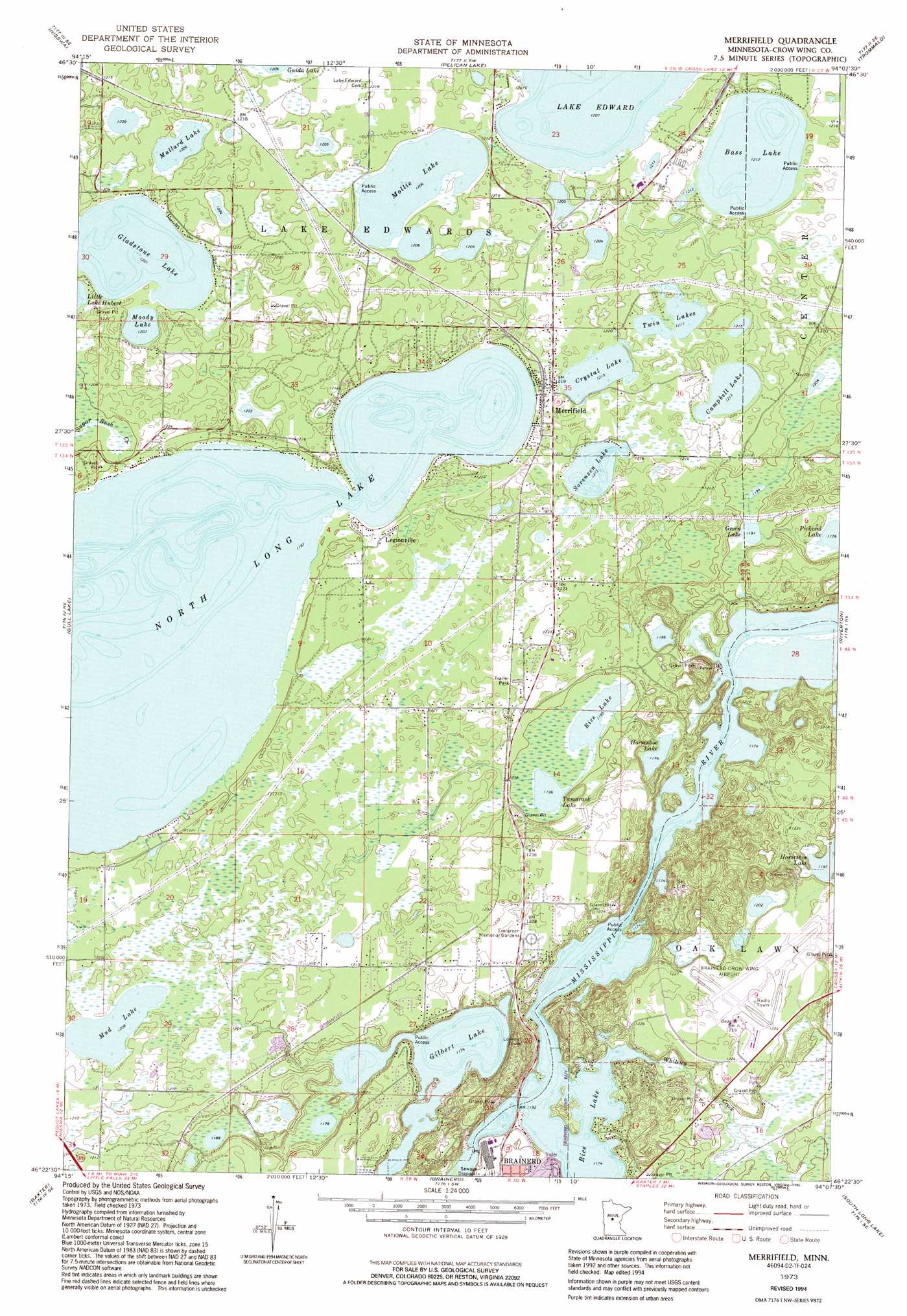
USGS Topo Quad 46094d2 - 1:24,000 scale
| Topo Map Name: | Merrifield |
| USGS Topo Quad ID: | 46094d2 |
| Print Size: | ca. 21 1/4" wide x 27" high |
| Southeast Coordinates: | 46.375° N latitude / 94.125° W longitude |
| Map Center Coordinates: | 46.4375° N latitude / 94.1875° W longitude |
| U.S. State: | MN |
| Filename: | o46094d2.jpg |
| Download Map JPG Image: | Merrifield topo map 1:24,000 scale |
| Map Type: | Topographic |
| Topo Series: | 7.5´ |
| Map Scale: | 1:24,000 |
| Source of Map Images: | United States Geological Survey (USGS) |
| Alternate Map Versions: |
Merrifield MN 1973, updated 1976 Download PDF Buy paper map Merrifield MN 1973, updated 1995 Download PDF Buy paper map Merrifield MN 2010 Download PDF Buy paper map Merrifield MN 2013 Download PDF Buy paper map Merrifield MN 2016 Download PDF Buy paper map |
1:24,000 Topo Quads surrounding Merrifield
Pine River |
Jenkins |
Lower Whitefish Lake |
Cross Lake |
Emily |
Pine River Sw |
Nisswa |
Pelican Lake |
Trommald |
Cuyuna |
Wilson Bay |
Gull Lake |
Merrifield |
Riverton |
Crosby |
Pillager |
Baxter |
Brainerd |
South Long Lake |
Grave Lake |
Belle Prairie Nw |
Fort Ripley |
Lastrup Nw |
Shephard |
Platte Lake |
> Back to 46094a1 at 1:100,000 scale
> Back to 46094a1 at 1:250,000 scale
> Back to U.S. Topo Maps home
Merrifield topo map: Gazetteer
Merrifield: Airports
Brainerd-Crow Wing County Regional Airport elevation 372m 1220′Merrifield: Dams
Brainerd Dam elevation 356m 1167′Merrifield: Lakes
Bass Lake elevation 369m 1210′Campbell Lake elevation 370m 1213′
Crystal Lake elevation 370m 1213′
Gilbert Lake elevation 358m 1174′
Gladstone Lake elevation 366m 1200′
Green Lake elevation 363m 1190′
Horseshoe Lake elevation 358m 1174′
Mallard Lake elevation 367m 1204′
Mollie Lake elevation 367m 1204′
Moody Lake elevation 366m 1200′
Mud Lake elevation 368m 1207′
North Long Lake elevation 364m 1194′
Pickerel Lake elevation 358m 1174′
Rice Lake elevation 364m 1194′
Rice Lake elevation 358m 1174′
Sorensen Lake elevation 370m 1213′
Tamarack Lake elevation 364m 1194′
Twin Lakes elevation 371m 1217′
Merrifield: Parks
Memorial Park elevation 366m 1200′Stewart C Mills Senior Field elevation 365m 1197′
Merrifield: Populated Places
Lazy Acre's Trailer Court elevation 375m 1230′Legionville elevation 370m 1213′
Merrifield elevation 372m 1220′
Supreme Mobile Court elevation 372m 1220′
Merrifield: Reservoirs
Rice Lake elevation 356m 1167′Merrifield: Streams
Whiteley Creek elevation 358m 1174′Merrifield digital topo map on disk
Buy this Merrifield topo map showing relief, roads, GPS coordinates and other geographical features, as a high-resolution digital map file on DVD: