Trommald Topo Map Minnesota
To zoom in, hover over the map of Trommald
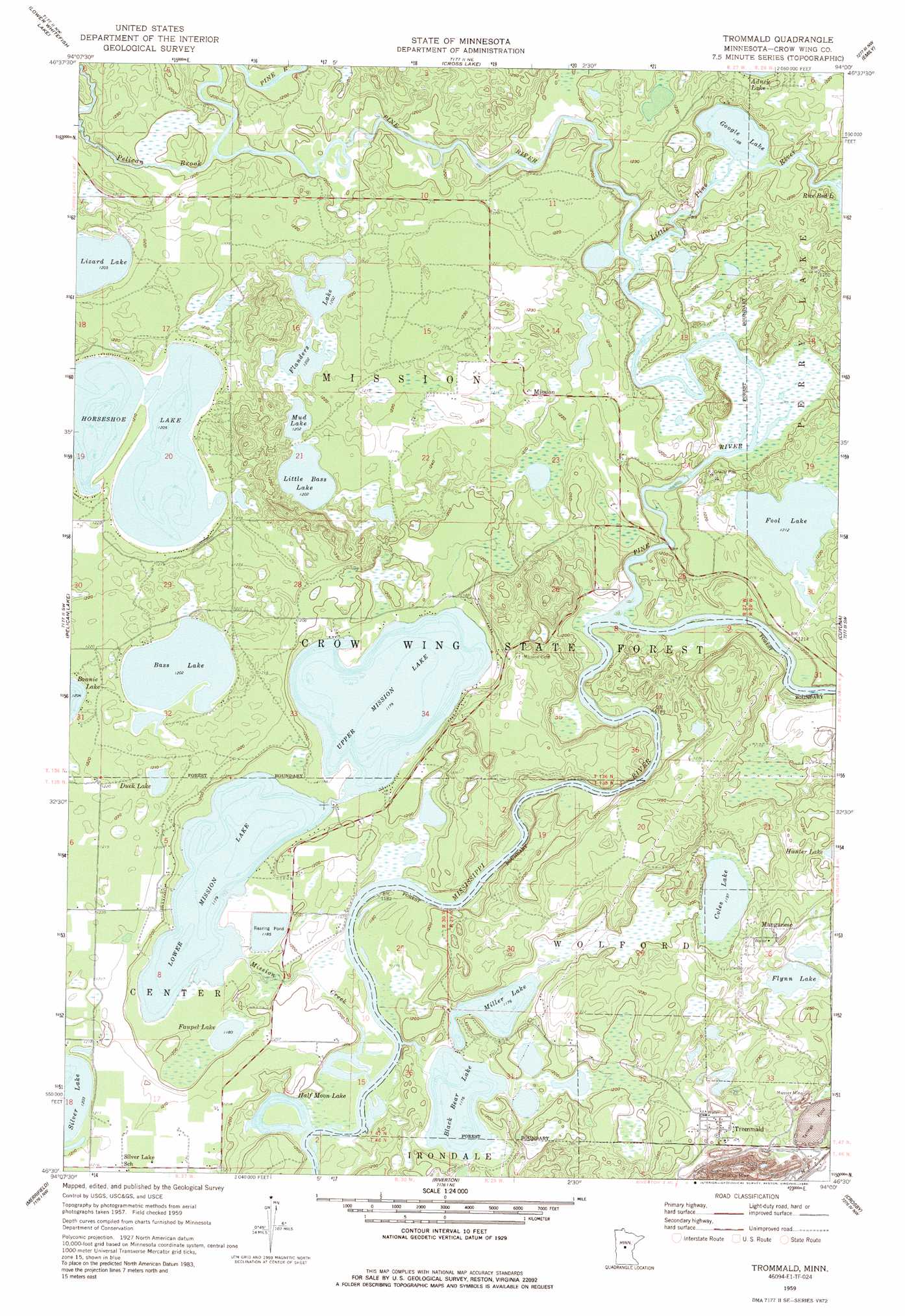
USGS Topo Quad 46094e1 - 1:24,000 scale
| Topo Map Name: | Trommald |
| USGS Topo Quad ID: | 46094e1 |
| Print Size: | ca. 21 1/4" wide x 27" high |
| Southeast Coordinates: | 46.5° N latitude / 94° W longitude |
| Map Center Coordinates: | 46.5625° N latitude / 94.0625° W longitude |
| U.S. State: | MN |
| Filename: | o46094e1.jpg |
| Download Map JPG Image: | Trommald topo map 1:24,000 scale |
| Map Type: | Topographic |
| Topo Series: | 7.5´ |
| Map Scale: | 1:24,000 |
| Source of Map Images: | United States Geological Survey (USGS) |
| Alternate Map Versions: |
Trommald MN 1959, updated 1960 Download PDF Buy paper map Trommald MN 1959, updated 1970 Download PDF Buy paper map Trommald MN 1959, updated 1986 Download PDF Buy paper map Trommald MN 2010 Download PDF Buy paper map Trommald MN 2013 Download PDF Buy paper map Trommald MN 2016 Download PDF Buy paper map |
1:24,000 Topo Quads surrounding Trommald
Lake Ada |
Stewart Lake |
Mitchell Lake |
Roosevelt Lake |
Edna Lake |
Jenkins |
Lower Whitefish Lake |
Cross Lake |
Emily |
Ross Lake |
Nisswa |
Pelican Lake |
Trommald |
Cuyuna |
Iron Hub |
Gull Lake |
Merrifield |
Riverton |
Crosby |
Bay Lake |
Baxter |
Brainerd |
South Long Lake |
Grave Lake |
Garrison |
> Back to 46094e1 at 1:100,000 scale
> Back to 46094a1 at 1:250,000 scale
> Back to U.S. Topo Maps home
Trommald topo map: Gazetteer
Trommald: Dams
Blackbear Lake Dam elevation 360m 1181′Trommald: Forests
Crow Wing State Forest elevation 370m 1213′Trommald: Lakes
Bass Lake elevation 367m 1204′Black Bear Lake elevation 358m 1174′
Coles Lake elevation 364m 1194′
Duck Lake elevation 367m 1204′
Faupel Lake elevation 360m 1181′
Flanders Lake elevation 367m 1204′
Flynn Lake elevation 370m 1213′
Fool Lake elevation 369m 1210′
Google Lake elevation 361m 1184′
Greenwood Lake elevation 367m 1204′
Half Moon Lake elevation 358m 1174′
Horseshoe Lake elevation 367m 1204′
Little Bass Lake elevation 367m 1204′
Lower Mission Lake elevation 359m 1177′
Miller Lake elevation 358m 1174′
Mud Lake elevation 367m 1204′
Upper Mission Lake elevation 359m 1177′
Trommald: Mines
Maroco Mine elevation 314m 1030′Musser Mine elevation 362m 1187′
Trommald: Populated Places
Manganese elevation 381m 1250′Mission elevation 375m 1230′
Trommald elevation 372m 1220′
Trommald: Post Offices
Manganese Post Office (historical) elevation 381m 1250′Mission Post Office (historical) elevation 376m 1233′
Trommald Post Office (historical) elevation 372m 1220′
Trommald: Reservoirs
Blackbear Lake elevation 360m 1181′Trommald: Streams
Little Pine River elevation 361m 1184′Mission Creek elevation 358m 1174′
Pelican Brook elevation 364m 1194′
Pine River elevation 358m 1174′
Trommald digital topo map on disk
Buy this Trommald topo map showing relief, roads, GPS coordinates and other geographical features, as a high-resolution digital map file on DVD: