Mildred Topo Map Minnesota
To zoom in, hover over the map of Mildred
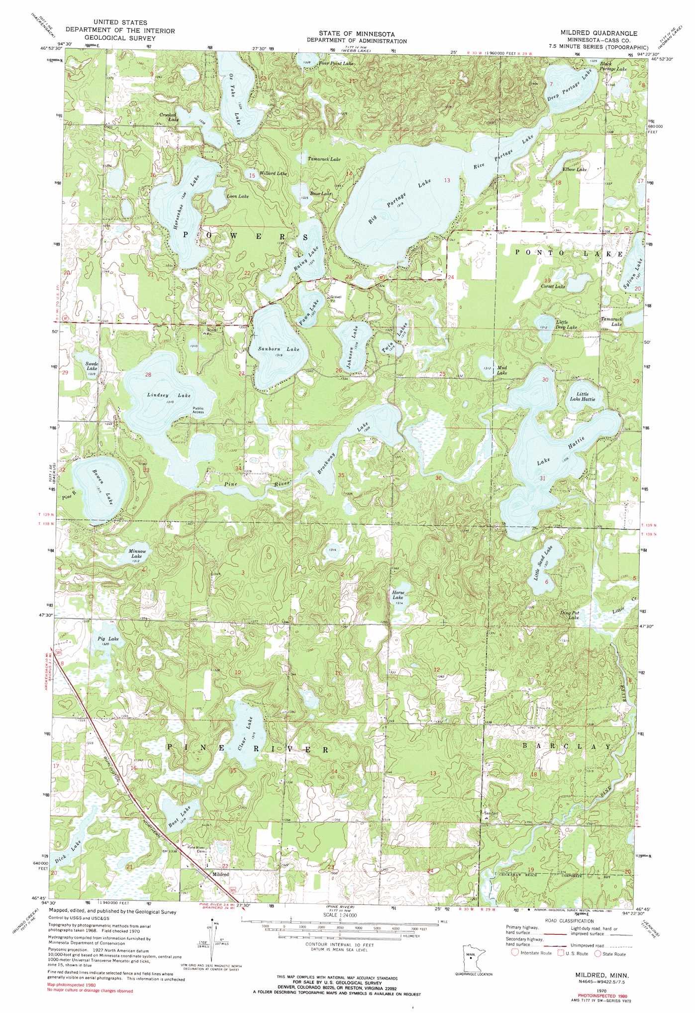
USGS Topo Quad 46094g4 - 1:24,000 scale
| Topo Map Name: | Mildred |
| USGS Topo Quad ID: | 46094g4 |
| Print Size: | ca. 21 1/4" wide x 27" high |
| Southeast Coordinates: | 46.75° N latitude / 94.375° W longitude |
| Map Center Coordinates: | 46.8125° N latitude / 94.4375° W longitude |
| U.S. State: | MN |
| Filename: | o46094g4.jpg |
| Download Map JPG Image: | Mildred topo map 1:24,000 scale |
| Map Type: | Topographic |
| Topo Series: | 7.5´ |
| Map Scale: | 1:24,000 |
| Source of Map Images: | United States Geological Survey (USGS) |
| Alternate Map Versions: |
Mildred MN 1970, updated 1972 Download PDF Buy paper map Mildred MN 1970, updated 1991 Download PDF Buy paper map Mildred MN 2010 Download PDF Buy paper map Mildred MN 2013 Download PDF Buy paper map Mildred MN 2016 Download PDF Buy paper map |
1:24,000 Topo Quads surrounding Mildred
Akeley |
Walker |
Jack Lake |
Whipholt |
Town Line Lake |
Crystal Lake |
Hackensack |
Webb Lake |
Woman Lake |
Longville |
Oshawa |
Backus |
Mildred |
Lake Ada |
Stewart Lake |
Spider Lake |
Bungo Creek |
Pine River |
Jenkins |
Lower Whitefish Lake |
Leader |
Graff |
Pine River Sw |
Nisswa |
Pelican Lake |
> Back to 46094e1 at 1:100,000 scale
> Back to 46094a1 at 1:250,000 scale
> Back to U.S. Topo Maps home
Mildred topo map: Gazetteer
Mildred: Dams
Bowen Lake Dam elevation 401m 1315′Hattie Lake Dam elevation 401m 1315′
Portage Lake Dam elevation 402m 1318′
Mildred: Lakes
Bass Lake elevation 403m 1322′Big Portage Lake elevation 402m 1318′
Boot Lake elevation 401m 1315′
Brockway Lake elevation 399m 1309′
Clear Lake elevation 401m 1315′
Corset Lake elevation 401m 1315′
Crooked Lake elevation 408m 1338′
Deep Portage Lake elevation 402m 1318′
Dick Lake elevation 401m 1315′
Ding Pot Lake elevation 399m 1309′
Elbow Lake elevation 404m 1325′
Fawn Lake elevation 404m 1325′
Horse Lake elevation 401m 1315′
Horseshoe Lake elevation 405m 1328′
Johnson Lake elevation 402m 1318′
Lindsey Lake elevation 400m 1312′
Little Deep Lake elevation 400m 1312′
Little Sand Lake elevation 399m 1309′
Loon Lake elevation 405m 1328′
Minnow Lake elevation 400m 1312′
Mud Lake elevation 400m 1312′
Ox Yoke Lake elevation 405m 1328′
Pig Lake elevation 403m 1322′
Rainy Lake elevation 404m 1325′
Rice Portage Lake elevation 402m 1318′
Sanborn Lake elevation 402m 1318′
Swede Lake elevation 405m 1328′
Sylvan Lake elevation 403m 1322′
Tamarack Lake elevation 404m 1325′
Twin Lakes elevation 401m 1315′
Willard Lake elevation 403m 1322′
Mildred: Populated Places
Mildred elevation 409m 1341′Mildred: Post Offices
Mildred Post Office (historical) elevation 408m 1338′Mildred: Reservoirs
Bowen Lake elevation 401m 1315′Hattie Lake elevation 401m 1315′
Lake Hattie elevation 399m 1309′
Little Lake Hattie elevation 398m 1305′
Portage Lake elevation 402m 1318′
Mildred: Streams
Lizzie Creek elevation 399m 1309′Mildred digital topo map on disk
Buy this Mildred topo map showing relief, roads, GPS coordinates and other geographical features, as a high-resolution digital map file on DVD: