Woman Lake Topo Map Minnesota
To zoom in, hover over the map of Woman Lake
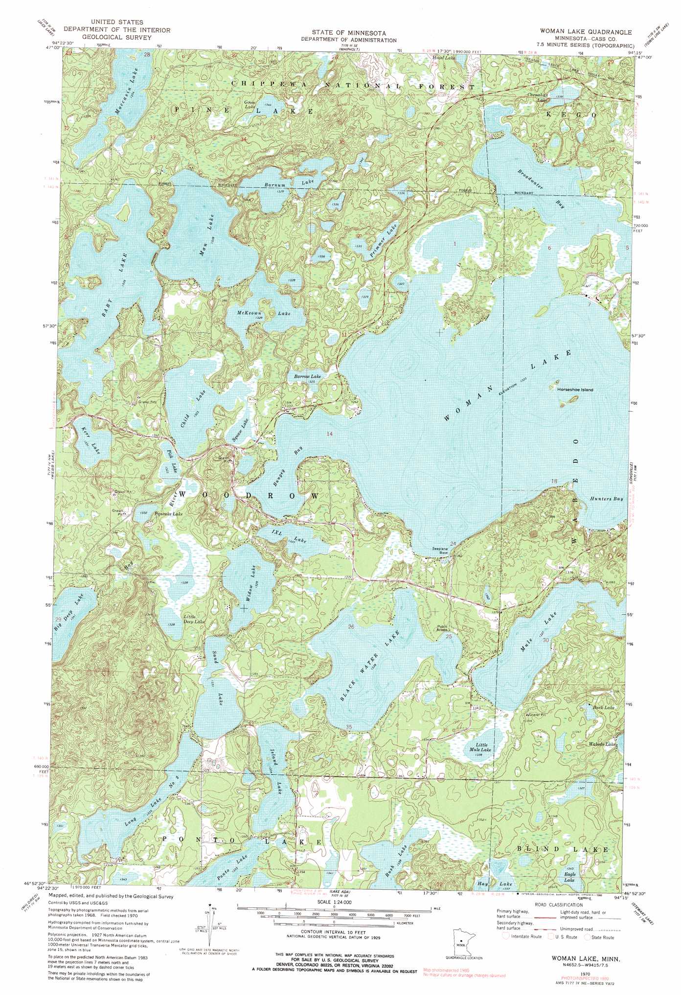
USGS Topo Quad 46094h3 - 1:24,000 scale
| Topo Map Name: | Woman Lake |
| USGS Topo Quad ID: | 46094h3 |
| Print Size: | ca. 21 1/4" wide x 27" high |
| Southeast Coordinates: | 46.875° N latitude / 94.25° W longitude |
| Map Center Coordinates: | 46.9375° N latitude / 94.3125° W longitude |
| U.S. State: | MN |
| Filename: | o46094h3.jpg |
| Download Map JPG Image: | Woman Lake topo map 1:24,000 scale |
| Map Type: | Topographic |
| Topo Series: | 7.5´ |
| Map Scale: | 1:24,000 |
| Source of Map Images: | United States Geological Survey (USGS) |
| Alternate Map Versions: |
Woman Lake MN 1970, updated 1972 Download PDF Buy paper map Woman Lake MN 1970, updated 1980 Download PDF Buy paper map Woman Lake MN 1970, updated 1990 Download PDF Buy paper map Woman Lake MN 1996, updated 1998 Download PDF Buy paper map Woman Lake MN 2011 Download PDF Buy paper map Woman Lake MN 2013 Download PDF Buy paper map Woman Lake MN 2016 Download PDF Buy paper map |
| FStopo: | US Forest Service topo Woman Lake is available: Download FStopo PDF Download FStopo TIF |
1:24,000 Topo Quads surrounding Woman Lake
Steamboat Bay |
Ottertail Point |
Sugar Point |
Federal Dam |
Boy River |
Walker |
Jack Lake |
Whipholt |
Town Line Lake |
Tobique |
Hackensack |
Webb Lake |
Woman Lake |
Longville |
Laura Lake |
Backus |
Mildred |
Lake Ada |
Stewart Lake |
Mitchell Lake |
Bungo Creek |
Pine River |
Jenkins |
Lower Whitefish Lake |
Cross Lake |
> Back to 46094e1 at 1:100,000 scale
> Back to 46094a1 at 1:250,000 scale
> Back to U.S. Topo Maps home
Woman Lake topo map: Gazetteer
Woman Lake: Bays
Broadwater Bay elevation 404m 1325′Bungey Bay elevation 404m 1325′
Hunters Bay elevation 404m 1325′
Woman Lake: Dams
Blackwater Lake Dam elevation 405m 1328′Woman Lake: Islands
Horseshoe Island elevation 412m 1351′Woman Lake: Lakes
Baby Lake elevation 405m 1328′Barnum Lake elevation 405m 1328′
Barrow Lake elevation 404m 1325′
Black Water Lake elevation 405m 1328′
Buck Lake elevation 407m 1335′
Carnahan Lake elevation 406m 1332′
Child Lake elevation 404m 1325′
Eagle Lake elevation 409m 1341′
Goose Lake elevation 409m 1341′
Hazel Lake elevation 413m 1354′
I X L Lake elevation 405m 1328′
Island Lake elevation 407m 1335′
Kerr Lake elevation 406m 1332′
Little Deep Lake elevation 405m 1328′
Little Mule Lake elevation 405m 1328′
Little Woman Lake elevation 404m 1325′
Long Lake Number Two elevation 407m 1335′
Man Lake elevation 405m 1328′
McKeown Lake elevation 405m 1328′
Moccasin Lake elevation 412m 1351′
Mule Lake elevation 405m 1328′
Pancake Lake elevation 406m 1332′
Pick Lake elevation 404m 1325′
Primmer Lake elevation 407m 1335′
Rush Lake elevation 408m 1338′
Sand Lake elevation 406m 1332′
Widow Lake elevation 405m 1328′
Woman Lake elevation 404m 1325′
Woman Lake: Reservoirs
Blackwater Lake elevation 405m 1328′Woman Lake: Trails
Goose Lake Trail System elevation 413m 1354′Woman Lake digital topo map on disk
Buy this Woman Lake topo map showing relief, roads, GPS coordinates and other geographical features, as a high-resolution digital map file on DVD: