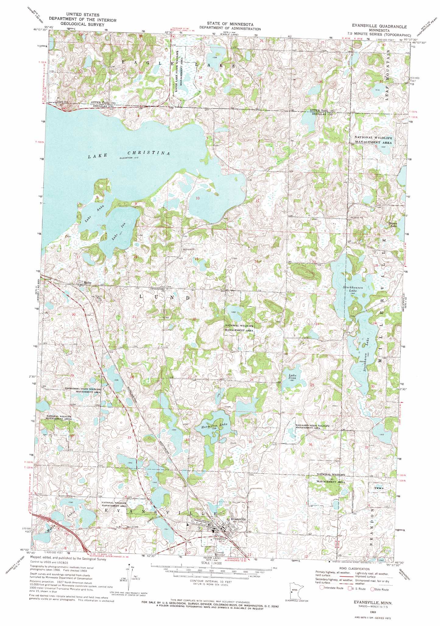
Evansville Topo Map Minnesota
To zoom in, hover over the map of Evansville
USGS Topo Quad 46095a6 - 1:24,000 scale
| Topo Map Name: | Evansville |
| USGS Topo Quad ID: | 46095a6 |
| Print Size: | ca. 21 1/4" wide x 27" high |
| Southeast Coordinates: | 46° N latitude / 95.625° W longitude |
| Map Center Coordinates: | 46.0625° N latitude / 95.6875° W longitude |
| U.S. State: | MN |
| Filename: | o46095a6.jpg |
| Download Map JPG Image: | Evansville topo map 1:24,000 scale |
| Map Type: | Topographic |
| Topo Series: | 7.5´ |
| Map Scale: | 1:24,000 |
| Source of Map Images: | United States Geological Survey (USGS) |
| Alternate Map Versions: |
Evansville MN 1969, updated 1971 Download PDF Buy paper map Evansville MN 2010 Download PDF Buy paper map Evansville MN 2013 Download PDF Buy paper map Evansville MN 2016 Download PDF Buy paper map |
1:24,000 Topo Quads surrounding Evansville
Wall Lake |
Underwood |
Battle Lake |
Vining |
Henning |
Dalton |
Stalker Lake |
Eagle Lake |
Inspiration Peak |
Parkers Prairie Nw |
Fourmile Lake |
Ashby |
Evansville |
Millerville |
Lake Miltona West |
Elbow Lake |
Erdahl |
Quam Lake |
Brandon |
Alexandria West |
Patchen Lake |
Hoffman |
Kensington |
Farwell |
Lake Mary |
> Back to 46095a1 at 1:100,000 scale
> Back to 46094a1 at 1:250,000 scale
> Back to U.S. Topo Maps home
Evansville topo map: Gazetteer
Evansville: Airports
Chuck West Memorial Heliport elevation 413m 1354′Elmer Airport elevation 409m 1341′
Evansville: Lakes
Horseshoe Lake elevation 410m 1345′Lake Anka elevation 370m 1213′
Lake Christina elevation 370m 1213′
Lake Ina elevation 370m 1213′
Lake Sina elevation 415m 1361′
Mahla Lakes elevation 406m 1332′
Stockhaven Lake elevation 410m 1345′
Stockhousen Lake elevation 410m 1345′
Evansville: Parks
Balgaard State Wildlife Management Area elevation 413m 1354′Eagle Lake State Wildlife Management Area elevation 373m 1223′
Thornberg State Wildlife Management Area elevation 402m 1318′
Evansville: Populated Places
Evansville elevation 412m 1351′Melby elevation 387m 1269′
Evansville: Post Offices
Evansville Post Office elevation 409m 1341′Melby Post Office (historical) elevation 387m 1269′
Evansville digital topo map on disk
Buy this Evansville topo map showing relief, roads, GPS coordinates and other geographical features, as a high-resolution digital map file on DVD: