Parkers Prairie Nw Topo Map Minnesota
To zoom in, hover over the map of Parkers Prairie Nw
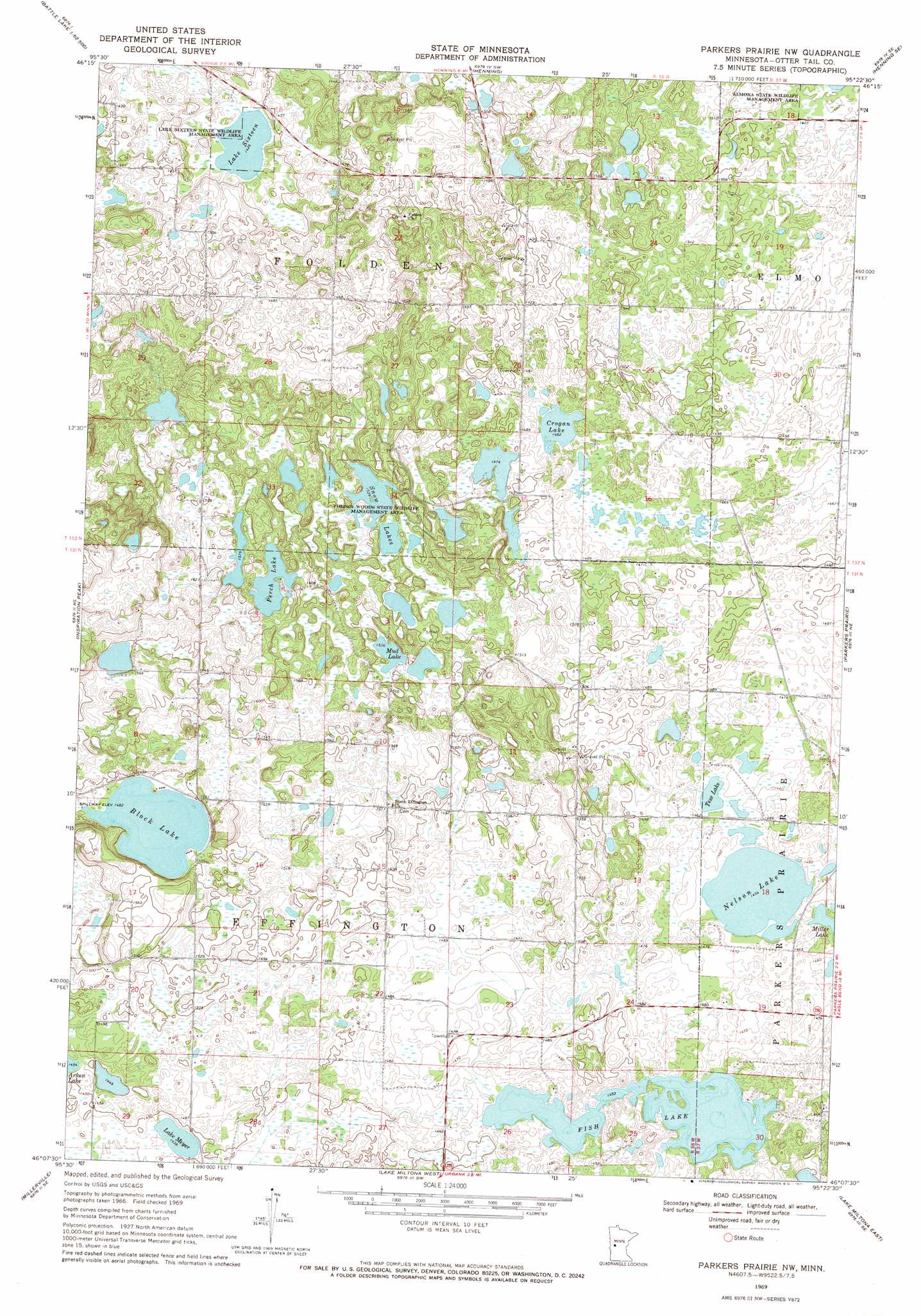
USGS Topo Quad 46095b4 - 1:24,000 scale
| Topo Map Name: | Parkers Prairie Nw |
| USGS Topo Quad ID: | 46095b4 |
| Print Size: | ca. 21 1/4" wide x 27" high |
| Southeast Coordinates: | 46.125° N latitude / 95.375° W longitude |
| Map Center Coordinates: | 46.1875° N latitude / 95.4375° W longitude |
| U.S. State: | MN |
| Filename: | o46095b4.jpg |
| Download Map JPG Image: | Parkers Prairie Nw topo map 1:24,000 scale |
| Map Type: | Topographic |
| Topo Series: | 7.5´ |
| Map Scale: | 1:24,000 |
| Source of Map Images: | United States Geological Survey (USGS) |
| Alternate Map Versions: |
Parkers Prairie NW MN 1969, updated 1971 Download PDF Buy paper map Parkers Prairie NW MN 2010 Download PDF Buy paper map Parkers Prairie NW MN 2013 Download PDF Buy paper map Parkers Prairie NW MN 2016 Download PDF Buy paper map |
1:24,000 Topo Quads surrounding Parkers Prairie Nw
Walker Lake |
Ottertail |
Heinola |
Deer Creek |
Wadena |
Battle Lake |
Vining |
Henning |
Henning Se |
Wrightstown |
Eagle Lake |
Inspiration Peak |
Parkers Prairie Nw |
Parkers Prairie |
Eagle Bend Nw |
Evansville |
Millerville |
Lake Miltona West |
Lake Miltona East |
Rose City |
Quam Lake |
Brandon |
Alexandria West |
Alexandria East |
Lake Osakis West |
> Back to 46095a1 at 1:100,000 scale
> Back to 46094a1 at 1:250,000 scale
> Back to U.S. Topo Maps home
Parkers Prairie Nw topo map: Gazetteer
Parkers Prairie Nw: Dams
Block Lake Dam elevation 451m 1479′Parkers Prairie Nw: Lakes
Crogan Lake elevation 446m 1463′Fish Lake elevation 443m 1453′
Lake Meyer elevation 437m 1433′
Lake Sixteen elevation 434m 1423′
Miller Lake elevation 443m 1453′
Mud Lake elevation 467m 1532′
Nelson Lake elevation 443m 1453′
Perch Lake elevation 476m 1561′
Snow Lakes elevation 464m 1522′
Tess Lake elevation 443m 1453′
Parkers Prairie Nw: Parks
Almora State Wildlife Management Area elevation 445m 1459′Folden Woods State Wildlife Management Area elevation 472m 1548′
Lake Sixteen State Wildlife Management Area elevation 434m 1423′
Parkers Prairie Nw: Post Offices
Effington Post Office (historical) elevation 445m 1459′Parkers Prairie Nw: Reservoirs
Block Lake elevation 451m 1479′Parkers Prairie Nw digital topo map on disk
Buy this Parkers Prairie Nw topo map showing relief, roads, GPS coordinates and other geographical features, as a high-resolution digital map file on DVD: