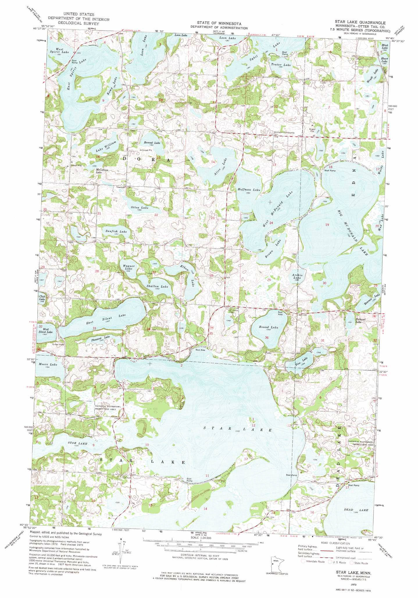
Star Lake Topo Map Minnesota
To zoom in, hover over the map of Star Lake
USGS Topo Quad 46095e7 - 1:24,000 scale
| Topo Map Name: | Star Lake |
| USGS Topo Quad ID: | 46095e7 |
| Print Size: | ca. 21 1/4" wide x 27" high |
| Southeast Coordinates: | 46.5° N latitude / 95.75° W longitude |
| Map Center Coordinates: | 46.5625° N latitude / 95.8125° W longitude |
| U.S. State: | MN |
| Filename: | o46095e7.jpg |
| Download Map JPG Image: | Star Lake topo map 1:24,000 scale |
| Map Type: | Topographic |
| Topo Series: | 7.5´ |
| Map Scale: | 1:24,000 |
| Source of Map Images: | United States Geological Survey (USGS) |
| Alternate Map Versions: |
Star Lake MN 1973, updated 1975 Download PDF Buy paper map Star Lake MN 2010 Download PDF Buy paper map Star Lake MN 2013 Download PDF Buy paper map Star Lake MN 2016 Download PDF Buy paper map |
1:24,000 Topo Quads surrounding Star Lake
Big Cormorant Lake |
Audubon |
Detroit Lakes |
Rochert |
Toad Mountain |
Cormorant |
Lake Franklin |
Vergas |
Frazee |
Little Pine Lake |
Pelican Rapids |
Lake Lida |
Star Lake |
Dent |
Perham |
Erhard |
Heilberger Lake |
Phelps |
Walker Lake |
Ottertail |
Fergus Falls |
Wall Lake |
Underwood |
Battle Lake |
Vining |
> Back to 46095e1 at 1:100,000 scale
> Back to 46094a1 at 1:250,000 scale
> Back to U.S. Topo Maps home
Star Lake topo map: Gazetteer
Star Lake: Airports
Krueger Loon Lake Seaplane Base elevation 415m 1361′Star Lake: Dams
Dry Sand Lake Wildlife Management Unit Dam elevation 409m 1341′McDonald Lakes Dam elevation 412m 1351′
Star Lake: Lakes
Alice Lake elevation 412m 1351′Archie Lake elevation 412m 1351′
Berend Lake elevation 415m 1361′
Big McDonald Lake elevation 412m 1351′
Brown Lake elevation 412m 1351′
East Silent Lake elevation 410m 1345′
East Spirit Lake elevation 415m 1361′
Elbow Lake elevation 408m 1338′
Heart Lake elevation 415m 1361′
Hoffman Lake elevation 412m 1351′
Kemp Lake elevation 415m 1361′
Lake William elevation 413m 1354′
McCollum Lake elevation 420m 1377′
Moore Lake elevation 410m 1345′
Ottos Lake elevation 412m 1351′
Pickerel Lake elevation 412m 1351′
Pine Lake elevation 410m 1345′
Pleasant Lake elevation 410m 1345′
Reames Lake elevation 412m 1351′
Round Lake elevation 409m 1341′
Shallow Lake elevation 410m 1345′
Star Lake elevation 406m 1332′
Sunfish Lake elevation 412m 1351′
Tenter Lake elevation 415m 1361′
Wagner Lake elevation 410m 1345′
Wendt Lake elevation 415m 1361′
West McDonald Lake elevation 412m 1351′
Star Lake: Post Offices
Dora Post Offie (historical) elevation 427m 1400′Redington Post Office (historical) elevation 416m 1364′
Spirit Lake Post Office (historical) elevation 418m 1371′
Star Lake: Reservoirs
Brown Lake elevation 412m 1351′Dry Sand Lake elevation 409m 1341′
Star Lake digital topo map on disk
Buy this Star Lake topo map showing relief, roads, GPS coordinates and other geographical features, as a high-resolution digital map file on DVD: