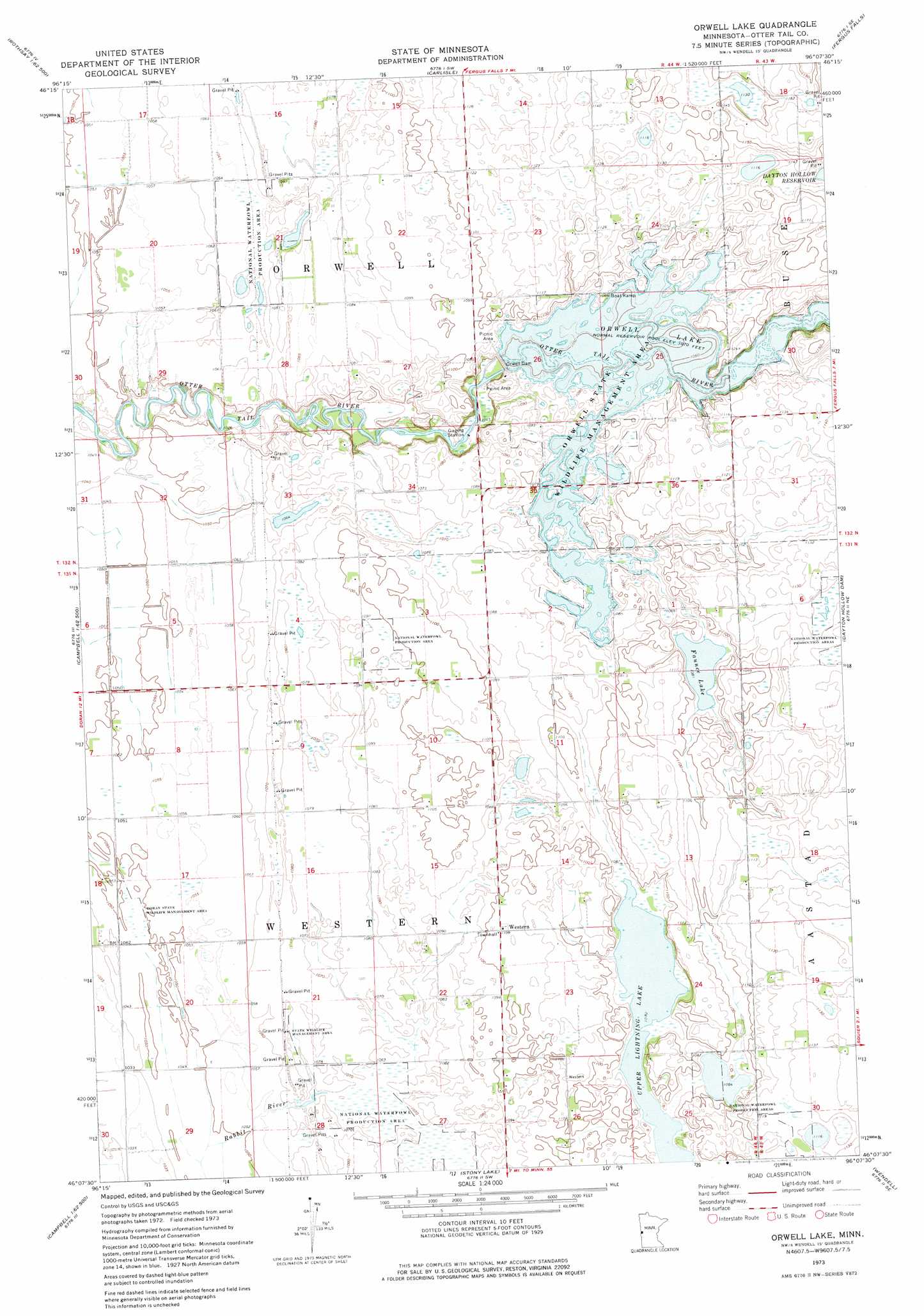
Orwell Lake Topo Map Minnesota
To zoom in, hover over the map of Orwell Lake
USGS Topo Quad 46096b2 - 1:24,000 scale
| Topo Map Name: | Orwell Lake |
| USGS Topo Quad ID: | 46096b2 |
| Print Size: | ca. 21 1/4" wide x 27" high |
| Southeast Coordinates: | 46.125° N latitude / 96.125° W longitude |
| Map Center Coordinates: | 46.1875° N latitude / 96.1875° W longitude |
| U.S. State: | MN |
| Filename: | o46096b2.jpg |
| Download Map JPG Image: | Orwell Lake topo map 1:24,000 scale |
| Map Type: | Topographic |
| Topo Series: | 7.5´ |
| Map Scale: | 1:24,000 |
| Source of Map Images: | United States Geological Survey (USGS) |
| Alternate Map Versions: |
Orwell Lake MN 1973, updated 1975 Download PDF Buy paper map Orwell Lake MN 2010 Download PDF Buy paper map Orwell Lake MN 2013 Download PDF Buy paper map Orwell Lake MN 2016 Download PDF Buy paper map |
1:24,000 Topo Quads surrounding Orwell Lake
Rothsay Nw |
Rothsay |
Elizabeth |
Erhard |
Heilberger Lake |
Everdell |
Foxhome |
Carlisle |
Fergus Falls |
Wall Lake |
Doran |
Campbell Ne |
Orwell Lake |
Dayton Hollow Dam |
Dalton |
Campbell |
Tintah |
Stony Lake |
Wendell |
Fourmile Lake |
Wheaton Nw |
Charlesville |
Herman Nw |
Trisko Lake |
Elbow Lake |
> Back to 46096a1 at 1:100,000 scale
> Back to 46096a1 at 1:250,000 scale
> Back to U.S. Topo Maps home
Orwell Lake topo map: Gazetteer
Orwell Lake: Dams
Orwell Dam elevation 320m 1049′Orwell Reservoir and Dam elevation 319m 1046′
Orwell Lake: Lakes
Faunce Lake elevation 330m 1082′Upper Lightning Lake elevation 330m 1082′
Orwell Lake: Parks
Doran State Wildlife Management Area elevation 320m 1049′Orwell State Wildlife Management Area elevation 329m 1079′
Orwell Lake: Populated Places
Roberts (historical) elevation 334m 1095′Western elevation 337m 1105′
Orwell Lake: Post Offices
Roberts Post Office (historical) elevation 333m 1092′Western Post Office (historical) elevation 337m 1105′
Orwell Lake: Reservoirs
Orwell Lake elevation 318m 1043′Orwell Reservoir elevation 319m 1046′
Orwell Lake digital topo map on disk
Buy this Orwell Lake topo map showing relief, roads, GPS coordinates and other geographical features, as a high-resolution digital map file on DVD:
Eastern North Dakota & Eastern South Dakota
Buy digital topo maps: Eastern North Dakota & Eastern South Dakota