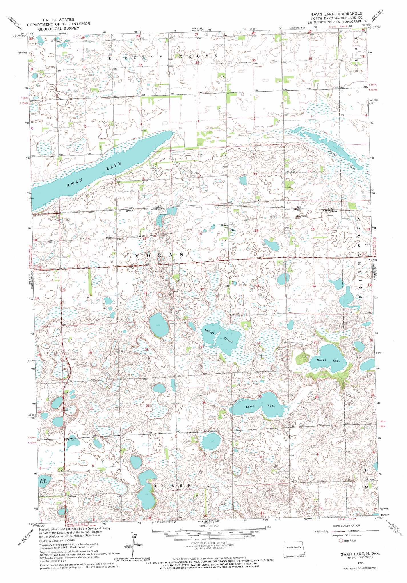
Swan Lake Topo Map North Dakota
To zoom in, hover over the map of Swan Lake
USGS Topo Quad 46097a1 - 1:24,000 scale
| Topo Map Name: | Swan Lake |
| USGS Topo Quad ID: | 46097a1 |
| Print Size: | ca. 21 1/4" wide x 27" high |
| Southeast Coordinates: | 46° N latitude / 97° W longitude |
| Map Center Coordinates: | 46.0625° N latitude / 97.0625° W longitude |
| U.S. State: | ND |
| Filename: | O46097A1.jpg |
| Download Map JPG Image: | Swan Lake topo map 1:24,000 scale |
| Map Type: | Topographic |
| Topo Series: | 7.5´ |
| Map Scale: | 1:24,000 |
| Source of Map Images: | United States Geological Survey (USGS) |
| Alternate Map Versions: |
Swan Lake ND 1964, updated 1965 Download PDF Buy paper map Swan Lake ND 2011 Download PDF Buy paper map Swan Lake ND 2014 Download PDF Buy paper map |
1:24,000 Topo Quads surrounding Swan Lake
De Lamere |
Wyndmere |
Wyndmere Se |
Mooreton West |
Mooreton East |
Hamlin |
Kreiser Lake |
Moselle |
Mantador |
Great Bend |
Geneseo |
Lidgerwood |
Swan Lake |
Hankinson |
Hankinson Se |
Veblen Ne |
Claire City Nw |
Claire City Ne |
New Effington Nw |
New Effington Ne |
Veblen |
Claire City Sw |
Claire City |
New Effington |
Victor |
> Back to 46097a1 at 1:100,000 scale
> Back to 46096a1 at 1:250,000 scale
> Back to U.S. Topo Maps home
Swan Lake topo map: Gazetteer
Swan Lake: Guts
Gullys Slough elevation 343m 1125′Stacks Slough elevation 329m 1079′
Swan Lake: Lakes
Lueck Lake elevation 345m 1131′Moran Lake elevation 336m 1102′
Swan Lake elevation 328m 1076′
Swan Lake: Populated Places
Stiles elevation 347m 1138′Swan Lake digital topo map on disk
Buy this Swan Lake topo map showing relief, roads, GPS coordinates and other geographical features, as a high-resolution digital map file on DVD:
Eastern North Dakota & Eastern South Dakota
Buy digital topo maps: Eastern North Dakota & Eastern South Dakota