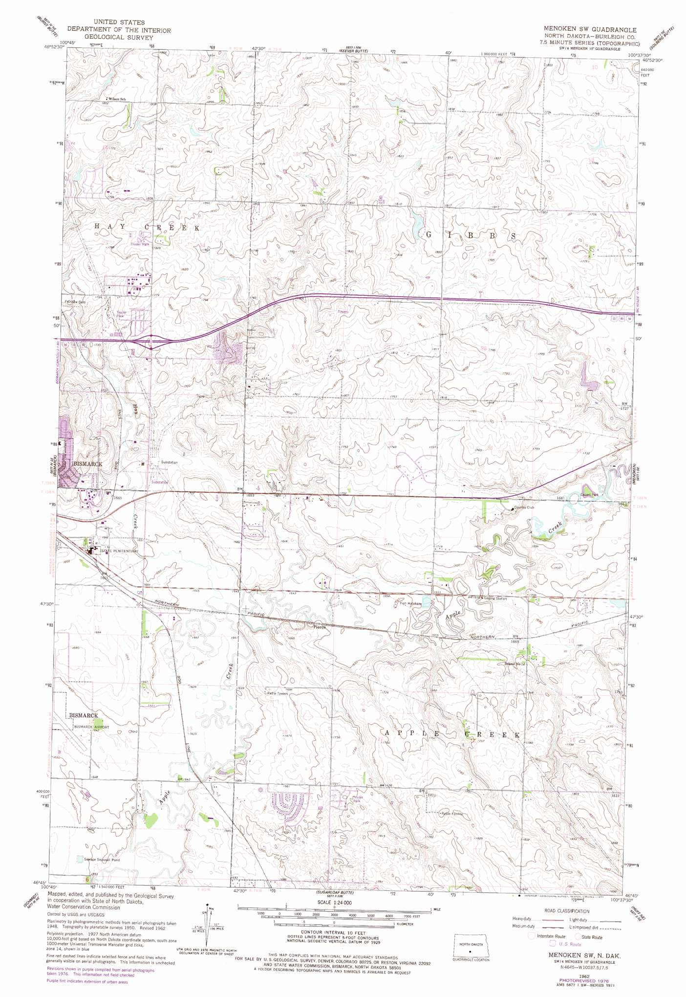
Menoken Sw Topo Map North Dakota
To zoom in, hover over the map of Menoken Sw
USGS Topo Quad 46100g6 - 1:24,000 scale
| Topo Map Name: | Menoken Sw |
| USGS Topo Quad ID: | 46100g6 |
| Print Size: | ca. 21 1/4" wide x 27" high |
| Southeast Coordinates: | 46.75° N latitude / 100.625° W longitude |
| Map Center Coordinates: | 46.8125° N latitude / 100.6875° W longitude |
| U.S. State: | ND |
| Filename: | O46100G6.jpg |
| Download Map JPG Image: | Menoken Sw topo map 1:24,000 scale |
| Map Type: | Topographic |
| Topo Series: | 7.5´ |
| Map Scale: | 1:24,000 |
| Source of Map Images: | United States Geological Survey (USGS) |
| Alternate Map Versions: |
Menoken SW ND 1951, updated 1951 Download PDF Buy paper map Menoken SW ND 1962, updated 1964 Download PDF Buy paper map Menoken SW ND 1962, updated 1977 Download PDF Buy paper map Menoken SW ND 2011 Download PDF Buy paper map Menoken SW ND 2014 Download PDF Buy paper map |
1:24,000 Topo Quads surrounding Menoken Sw
Price |
Wilton Se |
Baldwin |
Regan Se |
Wing Sw |
Harmon |
Burnt Butte |
Keever Butte |
Solberg Butte |
Mckenzie Nw |
Mandan |
Bismarck |
Menoken Sw |
Menoken |
Mckenzie |
Lynwood |
Schmidt |
Sugarloaf Butte |
Huff Ne |
Moffit Nw |
Saint Anthony |
The Hogback |
Huff |
Fort Rice |
Moffit Sw |
> Back to 46100e1 at 1:100,000 scale
> Back to 46100a1 at 1:250,000 scale
> Back to U.S. Topo Maps home
Menoken Sw topo map: Gazetteer
Menoken Sw: Dams
McDowell Dam elevation 524m 1719′Yegen Dam elevation 503m 1650′
Menoken Sw: Parks
Cypert Park elevation 506m 1660′Menoken Sw: Populated Places
Apple Creek Mobile Home Community elevation 534m 1751′Hillcrest Acres elevation 519m 1702′
Lincoln elevation 514m 1686′
Mister Bs Estates elevation 534m 1751′
Pierce elevation 504m 1653′
Menoken Sw: Streams
Hay Creek elevation 501m 1643′Menoken Sw digital topo map on disk
Buy this Menoken Sw topo map showing relief, roads, GPS coordinates and other geographical features, as a high-resolution digital map file on DVD:
Eastern North Dakota & Eastern South Dakota
Buy digital topo maps: Eastern North Dakota & Eastern South Dakota