Twin Forks Reservoir Topo Map Montana
To zoom in, hover over the map of Twin Forks Reservoir
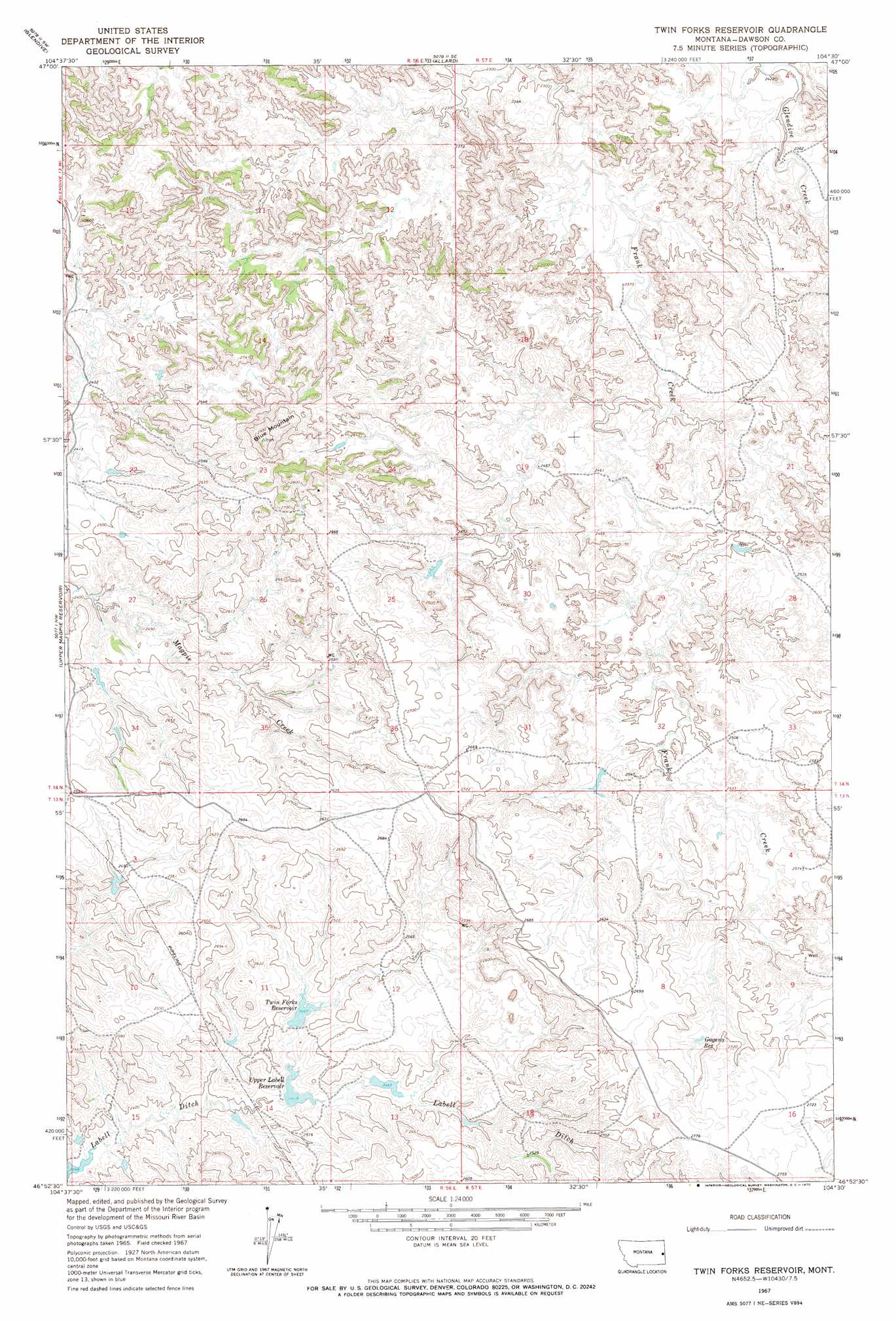
USGS Topo Quad 46104h5 - 1:24,000 scale
| Topo Map Name: | Twin Forks Reservoir |
| USGS Topo Quad ID: | 46104h5 |
| Print Size: | ca. 21 1/4" wide x 27" high |
| Southeast Coordinates: | 46.875° N latitude / 104.5° W longitude |
| Map Center Coordinates: | 46.9375° N latitude / 104.5625° W longitude |
| U.S. State: | MT |
| Filename: | o46104h5.jpg |
| Download Map JPG Image: | Twin Forks Reservoir topo map 1:24,000 scale |
| Map Type: | Topographic |
| Topo Series: | 7.5´ |
| Map Scale: | 1:24,000 |
| Source of Map Images: | United States Geological Survey (USGS) |
| Alternate Map Versions: |
Twin Forks Reservoir MT 1967, updated 1970 Download PDF Buy paper map Twin Forks Reservoir MT 2011 Download PDF Buy paper map Twin Forks Reservoir MT 2014 Download PDF Buy paper map |
1:24,000 Topo Quads surrounding Twin Forks Reservoir
Poverty Flat East |
Stipek |
Belle Prairie |
Cluster Buttes Nw |
Cluster Buttes |
Forest Park |
Glendive |
Allard |
Cluster Buttes Sw |
Cluster Buttes Se |
Hoyt |
Upper Magpie Reservoir |
Twin Forks Reservoir |
Hodges |
Freeman Creek |
Simons Butte |
Graveyard Hill Sw |
Graveyard Hill |
Hodges Sw |
Hodges Se |
Mildred Ne |
Dorothy Draw |
Ayer Spring Ne |
Rocking Chair Butte |
Cap Rock |
> Back to 46104e1 at 1:100,000 scale
> Back to 46104a1 at 1:250,000 scale
> Back to U.S. Topo Maps home
Twin Forks Reservoir topo map: Gazetteer
Twin Forks Reservoir: Dams
Dwarf Dam elevation 764m 2506′Lobella Dam elevation 737m 2417′
Lost Coulee Dam elevation 837m 2746′
Twin Forks Dam elevation 748m 2454′
Twin Forks Reservoir: Reservoirs
Gagena Reservoir elevation 808m 2650′Twin Forks Reservoir elevation 744m 2440′
Twin Forks Reservoir elevation 748m 2454′
Upper Labell Reservoir elevation 737m 2417′
Twin Forks Reservoir: Summits
Blue Mountain elevation 904m 2965′Twin Forks Reservoir: Wells
13N56E01BDAD01 Well elevation 824m 2703′13N56E02BBDD01 Well elevation 820m 2690′
13N57E18CDAA01 Well elevation 771m 2529′
14N56E11CDCB01 Well elevation 751m 2463′
14N56E34BBAD01 Well elevation 744m 2440′
14N57E21AC__01 Well elevation 757m 2483′
14N57E28BBBD01 Well elevation 763m 2503′
14N57E32CDBD01 Well elevation 772m 2532′
14N57E33BDCC01 Well elevation 768m 2519′
Twin Forks Reservoir digital topo map on disk
Buy this Twin Forks Reservoir topo map showing relief, roads, GPS coordinates and other geographical features, as a high-resolution digital map file on DVD:
Eastern Montana & Western North Dakota
Buy digital topo maps: Eastern Montana & Western North Dakota