Kinsey Ne Topo Map Montana
To zoom in, hover over the map of Kinsey Ne
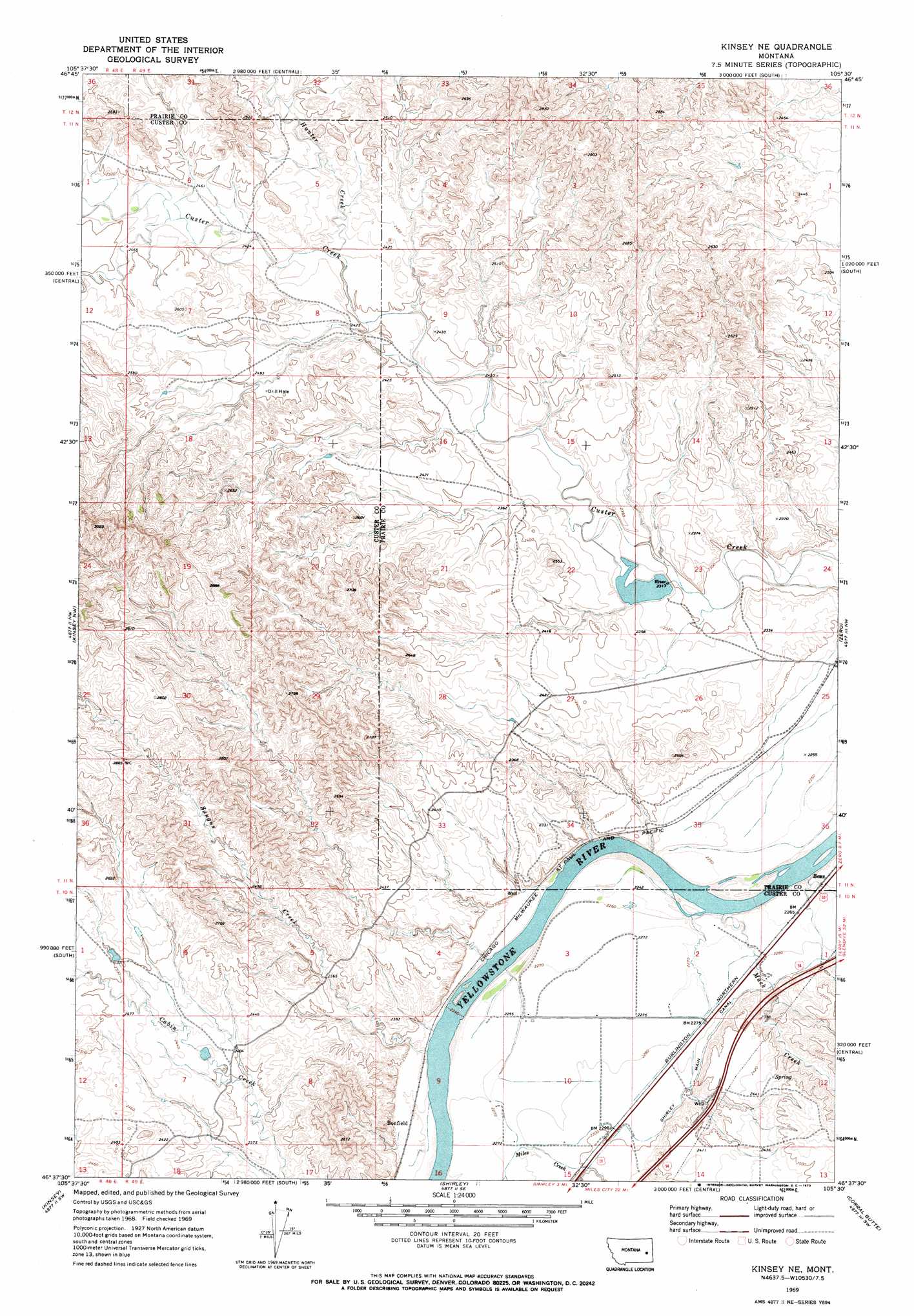
USGS Topo Quad 46105f5 - 1:24,000 scale
| Topo Map Name: | Kinsey Ne |
| USGS Topo Quad ID: | 46105f5 |
| Print Size: | ca. 21 1/4" wide x 27" high |
| Southeast Coordinates: | 46.625° N latitude / 105.5° W longitude |
| Map Center Coordinates: | 46.6875° N latitude / 105.5625° W longitude |
| U.S. State: | MT |
| Filename: | o46105f5.jpg |
| Download Map JPG Image: | Kinsey Ne topo map 1:24,000 scale |
| Map Type: | Topographic |
| Topo Series: | 7.5´ |
| Map Scale: | 1:24,000 |
| Source of Map Images: | United States Geological Survey (USGS) |
| Alternate Map Versions: |
Kinsey NE MT 1969, updated 1973 Download PDF Buy paper map Kinsey NE MT 2011 Download PDF Buy paper map Kinsey NE MT 2014 Download PDF Buy paper map |
1:24,000 Topo Quads surrounding Kinsey Ne
Little Sheep Mountain |
South Fork Reservoir |
Mccloud |
Papps Reservoir |
Diamond G Creek |
Morehouse Creek |
Physic Creek |
Mcclure Reservoir |
Calypso |
Terry |
Coal Bank Spring |
Kinsey Nw |
Kinsey Ne |
Zero |
Zero Ne |
Noble Reservoir |
Kinsey |
Shirley |
Corral Butte |
Spring Draw |
Miles City |
Government Hill |
The Knob |
Buck Mountain |
Locate |
> Back to 46105e1 at 1:100,000 scale
> Back to 46104a1 at 1:250,000 scale
> Back to U.S. Topo Maps home
Kinsey Ne topo map: Gazetteer
Kinsey Ne: Canals
Shirley Main Canal elevation 707m 2319′Kinsey Ne: Cliffs
Devils Backbone elevation 700m 2296′Kinsey Ne: Dams
Custer Creek Dam elevation 704m 2309′Haughian Number 12 Dam elevation 738m 2421′
Kinsey Ne: Populated Places
Benz elevation 692m 2270′Bonfield elevation 689m 2260′
Kinsey Ne: Streams
Hunter Creek elevation 723m 2372′Mack Creek elevation 678m 2224′
Saugus Creek elevation 684m 2244′
Williams Creek elevation 678m 2224′
Kinsey Ne: Wells
10N49E01BAC_01 Well elevation 696m 2283′10N49E01CCAC01 Well elevation 703m 2306′
10N49E05DBDC01 Well elevation 715m 2345′
11N49E24ACCC01 Well elevation 684m 2244′
Kinsey Ne digital topo map on disk
Buy this Kinsey Ne topo map showing relief, roads, GPS coordinates and other geographical features, as a high-resolution digital map file on DVD:
Eastern Montana & Western North Dakota
Buy digital topo maps: Eastern Montana & Western North Dakota