Calypso Topo Map Montana
To zoom in, hover over the map of Calypso
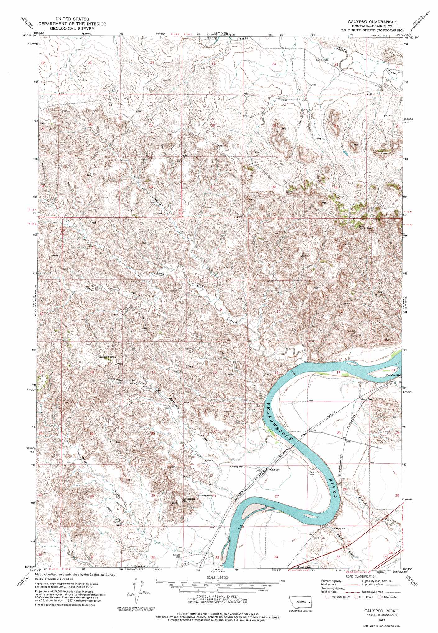
USGS Topo Quad 46105g4 - 1:24,000 scale
| Topo Map Name: | Calypso |
| USGS Topo Quad ID: | 46105g4 |
| Print Size: | ca. 21 1/4" wide x 27" high |
| Southeast Coordinates: | 46.75° N latitude / 105.375° W longitude |
| Map Center Coordinates: | 46.8125° N latitude / 105.4375° W longitude |
| U.S. State: | MT |
| Filename: | o46105g4.jpg |
| Download Map JPG Image: | Calypso topo map 1:24,000 scale |
| Map Type: | Topographic |
| Topo Series: | 7.5´ |
| Map Scale: | 1:24,000 |
| Source of Map Images: | United States Geological Survey (USGS) |
| Alternate Map Versions: |
Calypso MT 1972, updated 1975 Download PDF Buy paper map Calypso MT 2011 Download PDF Buy paper map Calypso MT 2014 Download PDF Buy paper map |
1:24,000 Topo Quads surrounding Calypso
Big Sheep Mountain |
Becker Dam |
North Coulee |
Diamond G Butte |
Lindsay Sw |
South Fork Reservoir |
Mccloud |
Papps Reservoir |
Diamond G Creek |
Hendrickson Coulee |
Physic Creek |
Mcclure Reservoir |
Calypso |
Terry |
Fallon Sw |
Kinsey Nw |
Kinsey Ne |
Zero |
Zero Ne |
Flat Top Butte |
Kinsey |
Shirley |
Corral Butte |
Spring Draw |
Flat Top Butte Sw |
> Back to 46105e1 at 1:100,000 scale
> Back to 46104a1 at 1:250,000 scale
> Back to U.S. Topo Maps home
Calypso topo map: Gazetteer
Calypso: Bridges
Calipso Bridge (historical) elevation 665m 2181′Calypso: Populated Places
Calypso elevation 682m 2237′Calypso: Rapids
Wolf Rapids elevation 669m 2194′Calypso: Springs
Calypso Spring elevation 792m 2598′Calypso: Streams
Camp Creek elevation 686m 2250′Coal Mine Creek elevation 671m 2201′
Cow Creek elevation 686m 2250′
Crooked Creek elevation 667m 2188′
Deer Creek elevation 675m 2214′
Lost Boy Creek elevation 662m 2171′
North Fork Lost Boy Creek elevation 691m 2267′
Sand Creek elevation 668m 2191′
Sullivan Creek elevation 664m 2178′
Calypso: Summits
Sheridan Butte elevation 811m 2660′Calypso: Trails
Calypso Trail elevation 745m 2444′Calypso: Valleys
Conns Coulee elevation 672m 2204′Calypso: Wells
12N50E22AABB01 Well elevation 677m 2221′12N50E24CACD01 Well elevation 717m 2352′
12N50E32DAAA01 Well elevation 688m 2257′
12N50E34DACA01 Well elevation 685m 2247′
13N49E24CBBA01 Well elevation 783m 2568′
Swank Well elevation 688m 2257′
Calypso digital topo map on disk
Buy this Calypso topo map showing relief, roads, GPS coordinates and other geographical features, as a high-resolution digital map file on DVD:
Eastern Montana & Western North Dakota
Buy digital topo maps: Eastern Montana & Western North Dakota