Physic Creek Topo Map Montana
To zoom in, hover over the map of Physic Creek
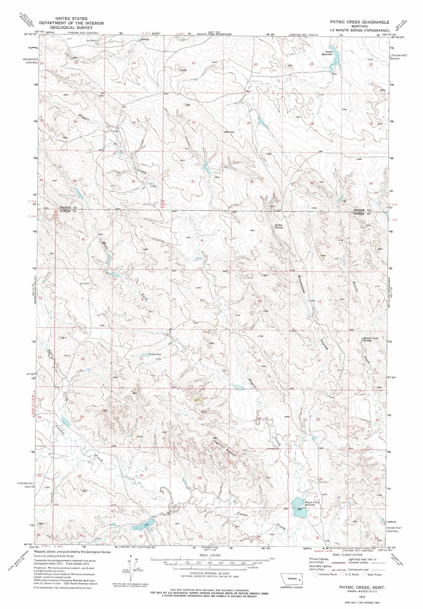
USGS Topo Quad 46105g6 - 1:24,000 scale
| Topo Map Name: | Physic Creek |
| USGS Topo Quad ID: | 46105g6 |
| Print Size: | ca. 21 1/4" wide x 27" high |
| Southeast Coordinates: | 46.75° N latitude / 105.625° W longitude |
| Map Center Coordinates: | 46.8125° N latitude / 105.6875° W longitude |
| U.S. State: | MT |
| Filename: | o46105g6.jpg |
| Download Map JPG Image: | Physic Creek topo map 1:24,000 scale |
| Map Type: | Topographic |
| Topo Series: | 7.5´ |
| Map Scale: | 1:24,000 |
| Source of Map Images: | United States Geological Survey (USGS) |
| Alternate Map Versions: |
Physic Creek MT 1972, updated 1976 Download PDF Buy paper map Physic Creek MT 2011 Download PDF Buy paper map Physic Creek MT 2014 Download PDF Buy paper map |
1:24,000 Topo Quads surrounding Physic Creek
Heitz School |
Watkins Se |
Big Sheep Mountain |
Becker Dam |
North Coulee |
Combs Ranch |
Little Sheep Mountain |
South Fork Reservoir |
Mccloud |
Papps Reservoir |
Twin Buttes School |
Morehouse Creek |
Physic Creek |
Mcclure Reservoir |
Calypso |
Horse Creek Hill |
Coal Bank Spring |
Kinsey Nw |
Kinsey Ne |
Zero |
Deadman Creek |
Noble Reservoir |
Kinsey |
Shirley |
Corral Butte |
> Back to 46105e1 at 1:100,000 scale
> Back to 46104a1 at 1:250,000 scale
> Back to U.S. Topo Maps home
Physic Creek topo map: Gazetteer
Physic Creek: Dams
Grant Reservoir Dam elevation 832m 2729′Harmes Reservoir Dam elevation 876m 2874′
Haughan Number 2 Dam elevation 823m 2700′
Haughian Number 15 Dam elevation 823m 2700′
Haughian Number 16 Dam elevation 807m 2647′
Physic Creek Dam elevation 780m 2559′
Reed Number 4 Dam elevation 814m 2670′
Reed Number 5 Dam elevation 802m 2631′
Swede Dam elevation 840m 2755′
Physic Creek: Reservoirs
Grant Reservoir elevation 832m 2729′Physic Creek Reservoir elevation 774m 2539′
Physic Creek: Springs
Fallon Spring elevation 865m 2837′Hunter Creek Spring elevation 798m 2618′
Physic Creek: Streams
Physic Creek elevation 771m 2529′Sadie Creek elevation 804m 2637′
West Fork Physic Creek elevation 804m 2637′
Physic Creek: Summits
Ingersol Butte elevation 875m 2870′Physic Creek: Valleys
Milwaukee Coulee elevation 786m 2578′Physic Creek: Wells
13N47E23BDDA01 Well elevation 883m 2896′13N47E24BACA01 Well elevation 879m 2883′
13N47E26DAAC01 Well elevation 852m 2795′
13N47E26DAAD01 Well elevation 854m 2801′
13N48E20CDDC01 Well elevation 854m 2801′
13N48E28DACC01 Well elevation 846m 2775′
13N48E29CBCA01 Well elevation 879m 2883′
13N48E33BBCA01 Well elevation 861m 2824′
Physic Creek digital topo map on disk
Buy this Physic Creek topo map showing relief, roads, GPS coordinates and other geographical features, as a high-resolution digital map file on DVD:
Eastern Montana & Western North Dakota
Buy digital topo maps: Eastern Montana & Western North Dakota