Horton Topo Map Montana
To zoom in, hover over the map of Horton
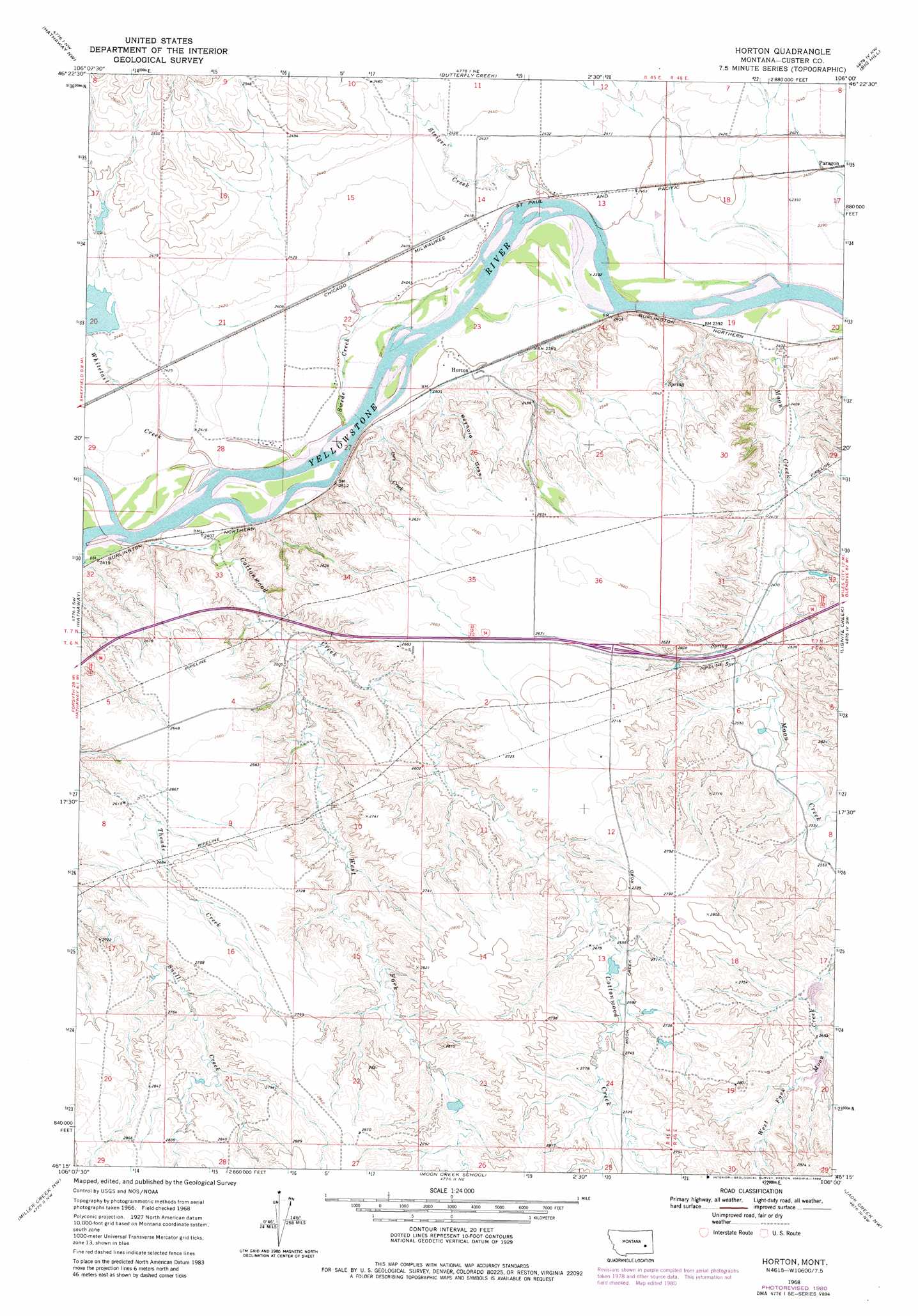
USGS Topo Quad 46106c1 - 1:24,000 scale
| Topo Map Name: | Horton |
| USGS Topo Quad ID: | 46106c1 |
| Print Size: | ca. 21 1/4" wide x 27" high |
| Southeast Coordinates: | 46.25° N latitude / 106° W longitude |
| Map Center Coordinates: | 46.3125° N latitude / 106.0625° W longitude |
| U.S. State: | MT |
| Filename: | o46106c1.jpg |
| Download Map JPG Image: | Horton topo map 1:24,000 scale |
| Map Type: | Topographic |
| Topo Series: | 7.5´ |
| Map Scale: | 1:24,000 |
| Source of Map Images: | United States Geological Survey (USGS) |
| Alternate Map Versions: |
Horton MT 1968, updated 1972 Download PDF Buy paper map Horton MT 1968, updated 1980 Download PDF Buy paper map Horton MT 2011 Download PDF Buy paper map Horton MT 2014 Download PDF Buy paper map |
1:24,000 Topo Quads surrounding Horton
Wild Horse Pass Se |
Hobo Coulee |
N Bar Coulee |
Deadman Creek |
Noble Reservoir |
Sand Buttes |
Hathaway Nw |
Butterfly Creek |
Big Hill |
Miles City |
Thurlow |
Hathaway |
Horton |
Lignite Creek |
Paddy Fay Creek |
Indian Creek |
Miller Creek Nw |
Moon Creek School |
Jack Creek Nw |
Circle L Creek |
Crain Place |
Miller Creek Sw |
Miller Creek |
Garland School |
Jack Creek |
> Back to 46106a1 at 1:100,000 scale
> Back to 46106a1 at 1:250,000 scale
> Back to U.S. Topo Maps home
Horton topo map: Gazetteer
Horton: Bridges
Cottonwood Creek Bridge elevation 818m 2683′Horton: Crossings
Interchange 126 elevation 812m 2664′Horton: Dams
Lockie Number 1 Dam elevation 816m 2677′Lockie Number 5 Dam elevation 812m 2664′
Lockie Number 6 Dam elevation 800m 2624′
Monarch Number 3 Dam elevation 755m 2477′
Whitetail Dam elevation 744m 2440′
Horton: Populated Places
Horton elevation 735m 2411′Paragon elevation 733m 2404′
Sadie (historical) elevation 733m 2404′
Horton: Post Offices
Horton Post Office (historical) elevation 733m 2404′Sadie Post Office (historical) elevation 733m 2404′
Horton: Streams
Cottonwood Creek elevation 732m 2401′Dry Creek elevation 729m 2391′
Moon Creek elevation 725m 2378′
Steiger Creek elevation 729m 2391′
Swede Creek elevation 730m 2395′
West Fork Cottonwood Creek elevation 751m 2463′
Whitetail Creek elevation 732m 2401′
Wilson Creek elevation 733m 2404′
Horton: Valleys
Reynold Draw elevation 733m 2404′Horton: Wells
07N45E24CDDD01 Well elevation 777m 2549′07N46E19DADA01 Well elevation 732m 2401′
Horton digital topo map on disk
Buy this Horton topo map showing relief, roads, GPS coordinates and other geographical features, as a high-resolution digital map file on DVD:
Eastern Montana & Western North Dakota
Buy digital topo maps: Eastern Montana & Western North Dakota