Donleys Reservoir Topo Map Montana
To zoom in, hover over the map of Donleys Reservoir
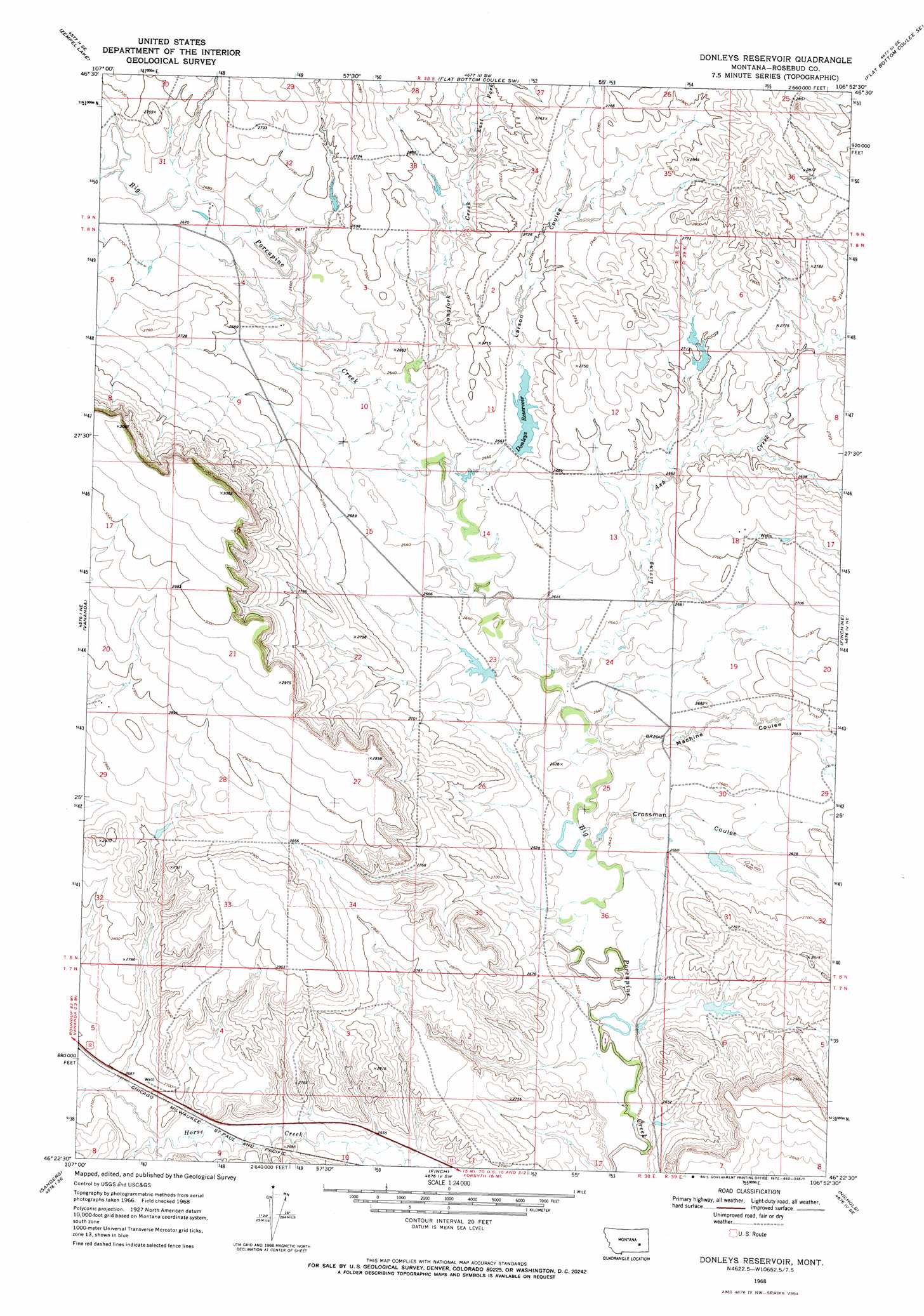
USGS Topo Quad 46106d8 - 1:24,000 scale
| Topo Map Name: | Donleys Reservoir |
| USGS Topo Quad ID: | 46106d8 |
| Print Size: | ca. 21 1/4" wide x 27" high |
| Southeast Coordinates: | 46.375° N latitude / 106.875° W longitude |
| Map Center Coordinates: | 46.4375° N latitude / 106.9375° W longitude |
| U.S. State: | MT |
| Filename: | o46106d8.jpg |
| Download Map JPG Image: | Donleys Reservoir topo map 1:24,000 scale |
| Map Type: | Topographic |
| Topo Series: | 7.5´ |
| Map Scale: | 1:24,000 |
| Source of Map Images: | United States Geological Survey (USGS) |
| Alternate Map Versions: |
Donleys Reservoir MT 1968, updated 1972 Download PDF Buy paper map Donleys Reservoir MT 2011 Download PDF Buy paper map Donleys Reservoir MT 2014 Download PDF Buy paper map |
1:24,000 Topo Quads surrounding Donleys Reservoir
Hagen Ranch |
Brown Coulee |
Flat Bottom Coulee Nw |
Flat Bottom Coulee Ne |
Rudie Coulee |
Thebes |
Zempel Lake |
Flat Bottom Coulee Sw |
Flat Bottom Coulee Se |
Rough Creek Sw |
Ahles |
Vananda |
Donleys Reservoir |
Finch Ne |
Black Coulee |
Hysham |
Sanders |
Finch |
Nichols |
Forsyth |
Scraper Coulee |
Woods Water |
Griffin Coulee Nw |
Griffin Coulee Ne |
Smith Creek |
> Back to 46106a1 at 1:100,000 scale
> Back to 46106a1 at 1:250,000 scale
> Back to U.S. Topo Maps home
Donleys Reservoir topo map: Gazetteer
Donleys Reservoir: Dams
Donley Reservoir Dam elevation 812m 2664′Erickson Number 3 Dam elevation 809m 2654′
Erickson Number 4 Dam elevation 805m 2641′
French Number 10 Dam elevation 869m 2851′
French Number 9 Dam elevation 906m 2972′
T L Johnson Number 1 Dam elevation 806m 2644′
T L Johnson Number 5 Dam elevation 822m 2696′
Donleys Reservoir: Post Offices
Otis Post Office (historical) elevation 806m 2644′Donleys Reservoir: Reservoirs
Donley Reservoir elevation 812m 2664′Donleys Reservoir elevation 812m 2664′
Donleys Reservoir: Streams
East Fork Longfork Creek elevation 812m 2664′Living Ash Creek elevation 800m 2624′
Longfork Creek elevation 806m 2644′
Donleys Reservoir: Valleys
Crossman Coulee elevation 799m 2621′Larson Coulee elevation 806m 2644′
Machine Coulee elevation 800m 2624′
Donleys Reservoir: Wells
08N38E20DC__01 Well elevation 878m 2880′08N38E24C___01 Well elevation 803m 2634′
Donleys Reservoir digital topo map on disk
Buy this Donleys Reservoir topo map showing relief, roads, GPS coordinates and other geographical features, as a high-resolution digital map file on DVD:
Eastern Montana & Western North Dakota
Buy digital topo maps: Eastern Montana & Western North Dakota