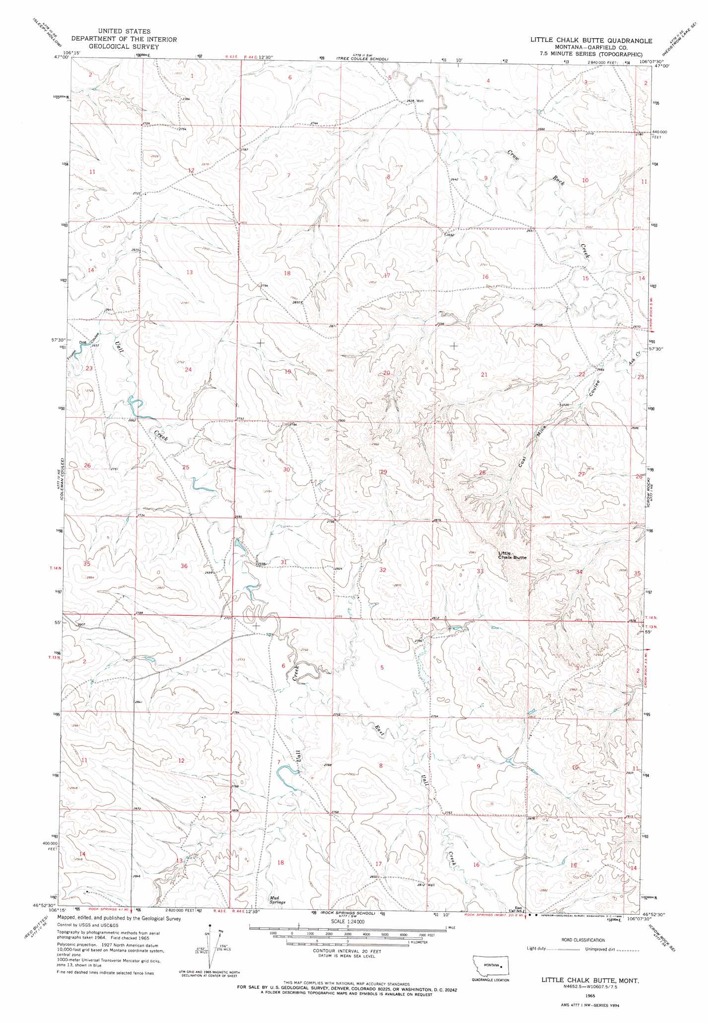
Little Chalk Butte Topo Map Montana
To zoom in, hover over the map of Little Chalk Butte
USGS Topo Quad 46106h2 - 1:24,000 scale
| Topo Map Name: | Little Chalk Butte |
| USGS Topo Quad ID: | 46106h2 |
| Print Size: | ca. 21 1/4" wide x 27" high |
| Southeast Coordinates: | 46.875° N latitude / 106.125° W longitude |
| Map Center Coordinates: | 46.9375° N latitude / 106.1875° W longitude |
| U.S. State: | MT |
| Filename: | o46106h2.jpg |
| Download Map JPG Image: | Little Chalk Butte topo map 1:24,000 scale |
| Map Type: | Topographic |
| Topo Series: | 7.5´ |
| Map Scale: | 1:24,000 |
| Source of Map Images: | United States Geological Survey (USGS) |
| Alternate Map Versions: |
Little Chalk Butte MT 1965, updated 1968 Download PDF Buy paper map Little Chalk Butte MT 2011 Download PDF Buy paper map Little Chalk Butte MT 2014 Download PDF Buy paper map |
1:24,000 Topo Quads surrounding Little Chalk Butte
Hafla School |
Whiteside Ranch |
Hedstrom Lake Nw |
Hedstrom Lake |
Berry School |
Calamity Coulee |
Sleepy Hollow |
Tree Coulee School |
Hedstrom Lake Se |
Heitz School |
Hillside |
Coleman Coulee |
Little Chalk Butte |
Crow Rock |
Combs Ranch |
Clear Water Reservoir |
Red Buttes |
Rock Springs School |
Crow Rock Se |
Twin Buttes School |
Van Burton Creek |
Alkali Creek |
Angela |
Angela Ne |
Horse Creek Hill |
> Back to 46106e1 at 1:100,000 scale
> Back to 46106a1 at 1:250,000 scale
> Back to U.S. Topo Maps home
Little Chalk Butte topo map: Gazetteer
Little Chalk Butte: Dams
Vic Jay Number 1 Dam elevation 836m 2742′Little Chalk Butte: Post Offices
Uoll Heights Post Office (historical) elevation 836m 2742′Little Chalk Butte: Springs
Mud Springs elevation 841m 2759′Little Chalk Butte: Streams
Ash Creek elevation 813m 2667′East Uall Creek elevation 830m 2723′
Little Chalk Butte: Summits
Little Chalk Butte elevation 891m 2923′Little Chalk Butte: Valleys
Coal Mine Coulee elevation 813m 2667′Frozen Dog Coulee elevation 812m 2664′
Little Chalk Butte: Wells
02N44E01BAAA01 Well elevation 875m 2870′13N44E06BABB01 Well elevation 826m 2709′
13N44E09CCBC01 Well elevation 840m 2755′
14N43E35DDAC01 Well elevation 850m 2788′
14N44E05DACC01 Well elevation 805m 2641′
14N44E16BBBD01 Well elevation 826m 2709′
14N44E18DCAB01 Well elevation 878m 2880′
14N44E22CDBB01 Well elevation 834m 2736′
Little Chalk Butte digital topo map on disk
Buy this Little Chalk Butte topo map showing relief, roads, GPS coordinates and other geographical features, as a high-resolution digital map file on DVD:
Eastern Montana & Western North Dakota
Buy digital topo maps: Eastern Montana & Western North Dakota