Big Marys Island Topo Map Montana
To zoom in, hover over the map of Big Marys Island
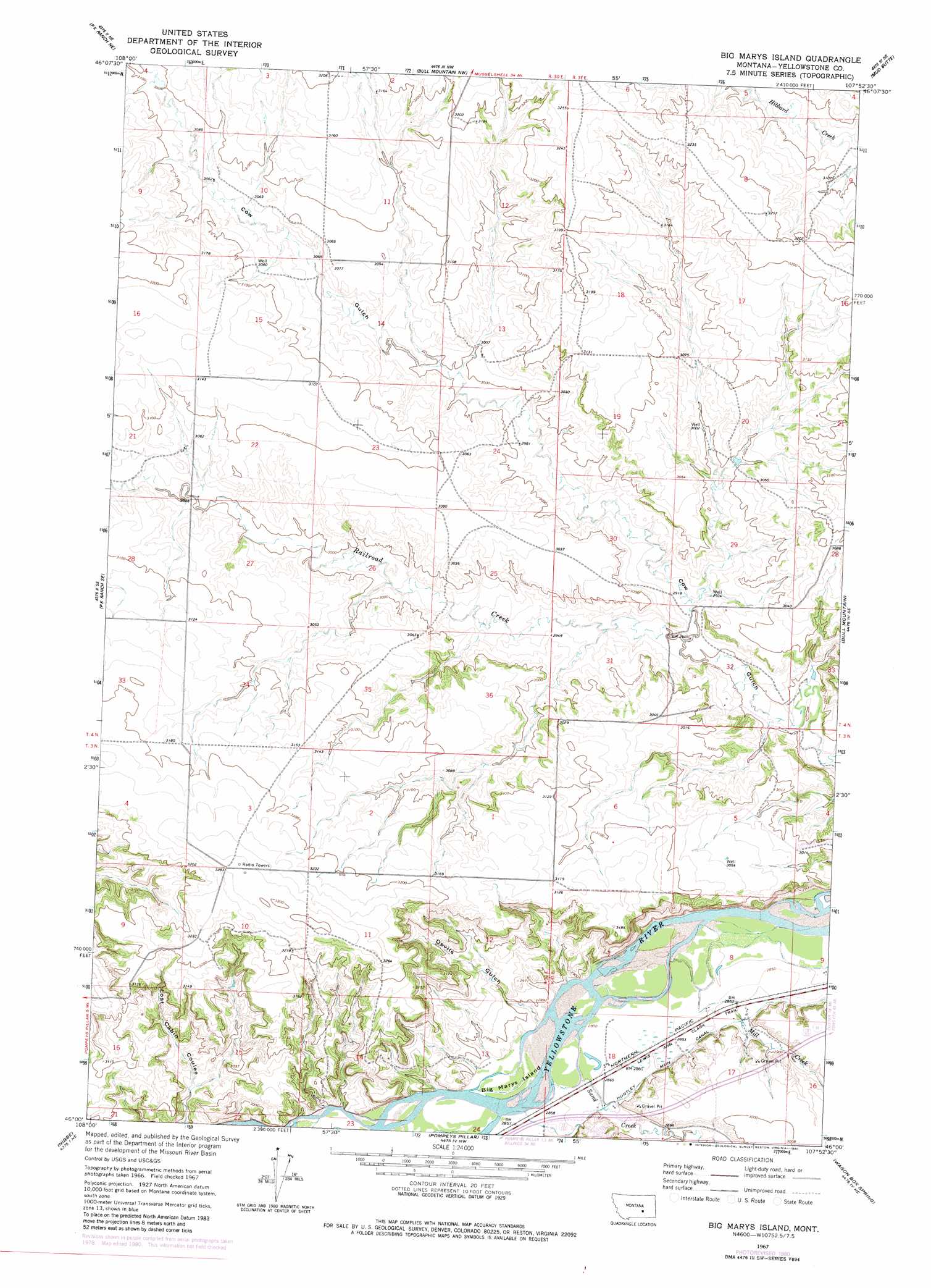
USGS Topo Quad 46107a8 - 1:24,000 scale
| Topo Map Name: | Big Marys Island |
| USGS Topo Quad ID: | 46107a8 |
| Print Size: | ca. 21 1/4" wide x 27" high |
| Southeast Coordinates: | 46° N latitude / 107.875° W longitude |
| Map Center Coordinates: | 46.0625° N latitude / 107.9375° W longitude |
| U.S. State: | MT |
| Filename: | o46107a8.jpg |
| Download Map JPG Image: | Big Marys Island topo map 1:24,000 scale |
| Map Type: | Topographic |
| Topo Series: | 7.5´ |
| Map Scale: | 1:24,000 |
| Source of Map Images: | United States Geological Survey (USGS) |
| Alternate Map Versions: |
Big Marys Island MT 1967, updated 1971 Download PDF Buy paper map Big Marys Island MT 1967, updated 1980 Download PDF Buy paper map Big Marys Island MT 2011 Download PDF Buy paper map Big Marys Island MT 2014 Download PDF Buy paper map |
1:24,000 Topo Quads surrounding Big Marys Island
Cherry Spring |
Steamboat Butte |
Pine View |
Mailbox Hill |
Mexican Buttes |
P K Ranch |
P K Ranch Ne |
Bull Mountain Nw |
Mud Butte |
Coal Bank Creek |
P K Ranch Sw |
P K Ranch Se |
Big Marys Island |
Bull Mountain |
Waco |
Worden |
Nibbe |
Pompeys Pillar |
Wagon Box Spring |
Lemon Ranch |
Indian Arrow |
Gails Coulee |
Corinth |
Blue Spring |
Chimney Creek |
> Back to 46107a1 at 1:100,000 scale
> Back to 46106a1 at 1:250,000 scale
> Back to U.S. Topo Maps home
Big Marys Island topo map: Gazetteer
Big Marys Island: Islands
Big Marys Island elevation 870m 2854′Big Marys Island: Streams
Mill Creek elevation 873m 2864′Railroad Creek elevation 886m 2906′
Sand Creek elevation 869m 2851′
Big Marys Island: Valleys
Devils Gulch elevation 873m 2864′Big Marys Island: Wells
03N30E10CDBC01 Well elevation 969m 3179′Big Marys Island digital topo map on disk
Buy this Big Marys Island topo map showing relief, roads, GPS coordinates and other geographical features, as a high-resolution digital map file on DVD:
Eastern Montana & Western North Dakota
Buy digital topo maps: Eastern Montana & Western North Dakota