Vananda Topo Map Montana
To zoom in, hover over the map of Vananda
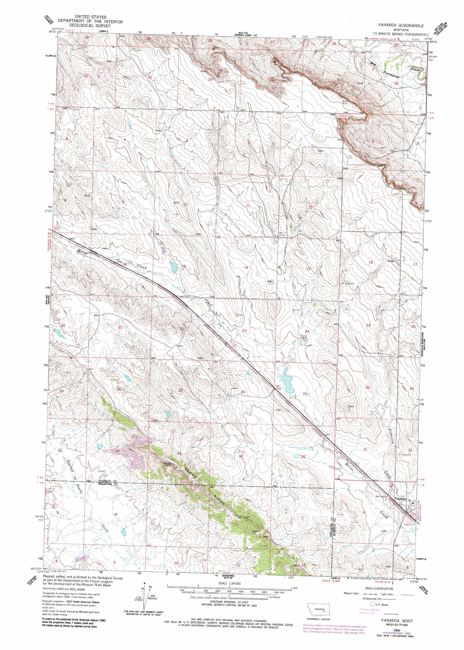
USGS Topo Quad 46107d1 - 1:24,000 scale
| Topo Map Name: | Vananda |
| USGS Topo Quad ID: | 46107d1 |
| Print Size: | ca. 21 1/4" wide x 27" high |
| Southeast Coordinates: | 46.375° N latitude / 107° W longitude |
| Map Center Coordinates: | 46.4375° N latitude / 107.0625° W longitude |
| U.S. State: | MT |
| Filename: | o46107d1.jpg |
| Download Map JPG Image: | Vananda topo map 1:24,000 scale |
| Map Type: | Topographic |
| Topo Series: | 7.5´ |
| Map Scale: | 1:24,000 |
| Source of Map Images: | United States Geological Survey (USGS) |
| Alternate Map Versions: |
Vananda MT 1960, updated 1962 Download PDF Buy paper map Vananda MT 1960, updated 1985 Download PDF Buy paper map Vananda MT 2011 Download PDF Buy paper map Vananda MT 2014 Download PDF Buy paper map |
1:24,000 Topo Quads surrounding Vananda
Black Sea Reservoir |
Hagen Ranch |
Brown Coulee |
Flat Bottom Coulee Nw |
Flat Bottom Coulee Ne |
Ingomar East |
Thebes |
Zempel Lake |
Flat Bottom Coulee Sw |
Flat Bottom Coulee Se |
Steie Ranch |
Ahles |
Vananda |
Donleys Reservoir |
Finch Ne |
Myers |
Hysham |
Sanders |
Finch |
Nichols |
Eldering Ranch |
Scraper Coulee |
Woods Water |
Griffin Coulee Nw |
Griffin Coulee Ne |
> Back to 46107a1 at 1:100,000 scale
> Back to 46106a1 at 1:250,000 scale
> Back to U.S. Topo Maps home
Vananda topo map: Gazetteer
Vananda: Dams
Big Timber Number 44 Dam elevation 848m 2782′Big Timber Number 47 Dam elevation 827m 2713′
Big Timber Number 49 Dam elevation 826m 2709′
Vananda: Mines
Cedar Ridge Junction Mine elevation 860m 2821′NE Cedar Ridge Mine elevation 865m 2837′
NW Cedar Ridge Mine elevation 834m 2736′
Roach Coulee 8,9 Mine elevation 821m 2693′
West Cedar Ridge Mine elevation 857m 2811′
Vananda: Populated Places
Vananda elevation 827m 2713′Vananda: Post Offices
Vananda Post Office (historical) elevation 826m 2709′Vananda: Ridges
Cedar Ridge elevation 881m 2890′Vananda: Streams
Anderson Creek elevation 817m 2680′Vananda: Wells
07N38E05B___01 Well elevation 827m 2713′07N38E05BA__01 Well elevation 831m 2726′
09N37E33DA__01 Well elevation 933m 3061′
Vananda digital topo map on disk
Buy this Vananda topo map showing relief, roads, GPS coordinates and other geographical features, as a high-resolution digital map file on DVD:
Eastern Montana & Western North Dakota
Buy digital topo maps: Eastern Montana & Western North Dakota