Dutton Ranch Topo Map Montana
To zoom in, hover over the map of Dutton Ranch
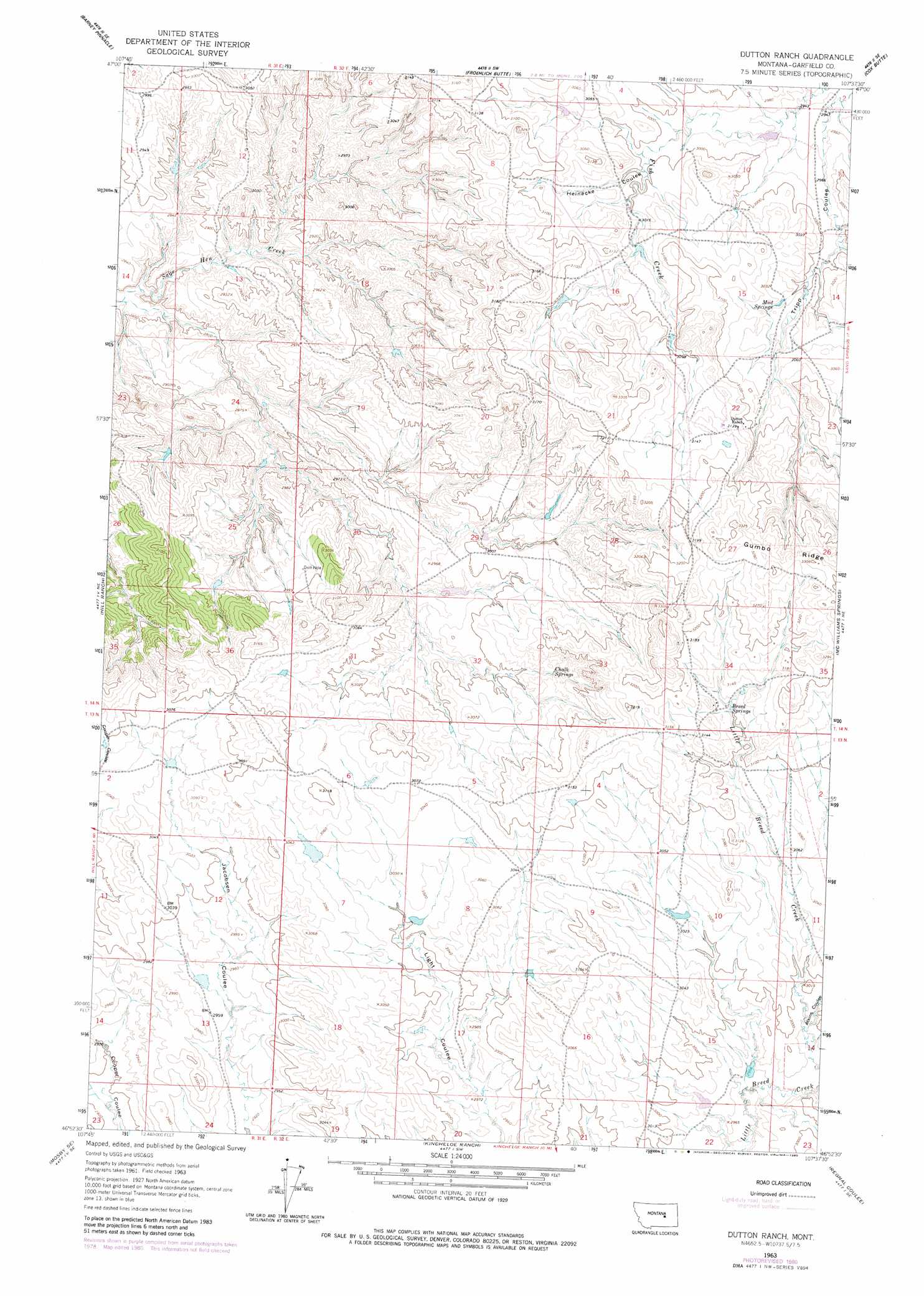
USGS Topo Quad 46107h6 - 1:24,000 scale
| Topo Map Name: | Dutton Ranch |
| USGS Topo Quad ID: | 46107h6 |
| Print Size: | ca. 21 1/4" wide x 27" high |
| Southeast Coordinates: | 46.875° N latitude / 107.625° W longitude |
| Map Center Coordinates: | 46.9375° N latitude / 107.6875° W longitude |
| U.S. State: | MT |
| Filename: | o46107h6.jpg |
| Download Map JPG Image: | Dutton Ranch topo map 1:24,000 scale |
| Map Type: | Topographic |
| Topo Series: | 7.5´ |
| Map Scale: | 1:24,000 |
| Source of Map Images: | United States Geological Survey (USGS) |
| Alternate Map Versions: |
Dutton Ranch MT 1963, updated 1965 Download PDF Buy paper map Dutton Ranch MT 1963, updated 1980 Download PDF Buy paper map Dutton Ranch MT 2011 Download PDF Buy paper map Dutton Ranch MT 2014 Download PDF Buy paper map |
1:24,000 Topo Quads surrounding Dutton Ranch
Bridge Coulee |
Lelig Coulee |
Searl Coulee |
Coffin Butte |
Twin Buttes |
Fail Ranch |
Barney Pinnacle |
Froehlich Butte |
Cox Butte |
Sand Springs |
Mosby |
Hill Ranch |
Dutton Ranch |
Mcwilliams Springs |
Mcginnis Butte |
Maxwell Ranch |
Mosby Se |
Kincheloe Ranch |
Regnal Coulee |
Mcginnis Butte Sw |
Melstone Nw |
Melstone Ne |
Grebe Ranch |
Hecker Ranch |
Yablonski Ranch |
> Back to 46107e1 at 1:100,000 scale
> Back to 46106a1 at 1:250,000 scale
> Back to U.S. Topo Maps home
Dutton Ranch topo map: Gazetteer
Dutton Ranch: Dams
BN Number 11 Dam elevation 922m 3024′L Galt Number 24 Dam elevation 901m 2956′
Dutton Ranch: Populated Places
Martin (historical) elevation 935m 3067′Dutton Ranch: Springs
Breed Springs elevation 953m 3126′Chalk Springs elevation 925m 3034′
Mud Springs elevation 920m 3018′
Dutton Ranch: Valleys
Atkins Coulee elevation 905m 2969′Heinecke Coulee elevation 909m 2982′
Dutton Ranch digital topo map on disk
Buy this Dutton Ranch topo map showing relief, roads, GPS coordinates and other geographical features, as a high-resolution digital map file on DVD:
Eastern Montana & Western North Dakota
Buy digital topo maps: Eastern Montana & Western North Dakota