Lavina Topo Map Montana
To zoom in, hover over the map of Lavina
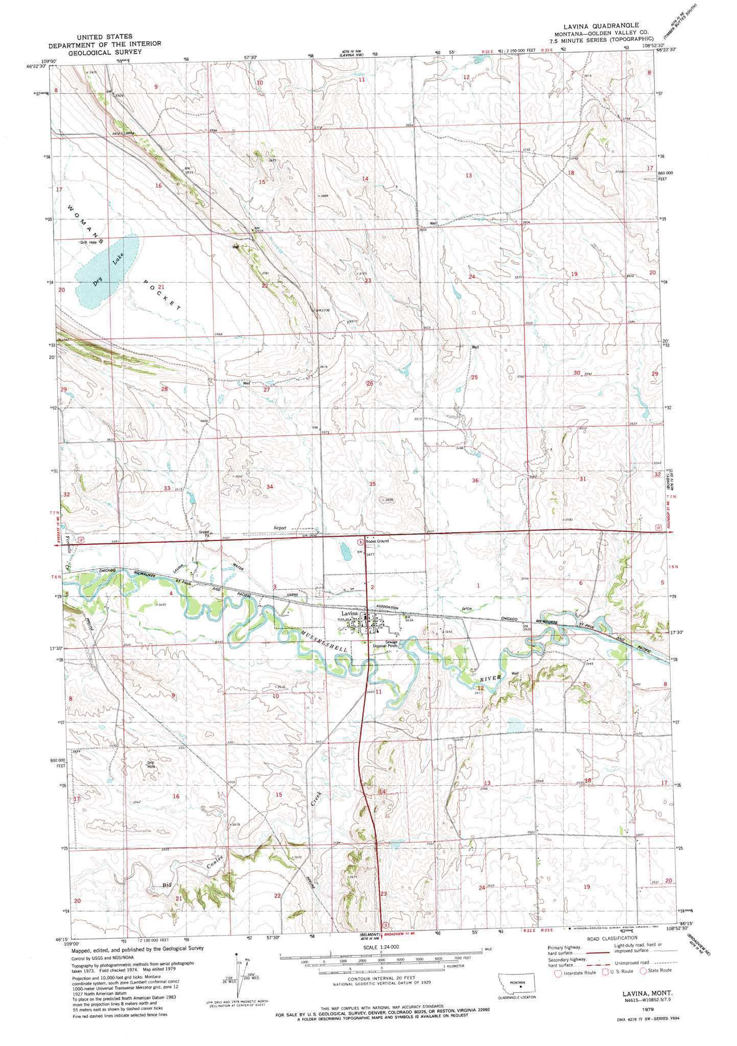
USGS Topo Quad 46108c8 - 1:24,000 scale
| Topo Map Name: | Lavina |
| USGS Topo Quad ID: | 46108c8 |
| Print Size: | ca. 21 1/4" wide x 27" high |
| Southeast Coordinates: | 46.25° N latitude / 108.875° W longitude |
| Map Center Coordinates: | 46.3125° N latitude / 108.9375° W longitude |
| U.S. State: | MT |
| Filename: | o46108c8.jpg |
| Download Map JPG Image: | Lavina topo map 1:24,000 scale |
| Map Type: | Topographic |
| Topo Series: | 7.5´ |
| Map Scale: | 1:24,000 |
| Source of Map Images: | United States Geological Survey (USGS) |
| Alternate Map Versions: |
Lavina MT 1979, updated 1980 Download PDF Buy paper map Lavina MT 2011 Download PDF Buy paper map Lavina MT 2014 Download PDF Buy paper map |
1:24,000 Topo Quads surrounding Lavina
Sahara Hill Sw |
Sahara Hill Se |
Emory School |
Timber Buttes North |
Lake Mason |
Cushman Nw |
Cushman Ne |
Lavina Nw |
Timber Buttes South |
Horse Thief Creek |
Ryegate East |
Cushman |
Lavina |
Bundy |
Elso |
Mount Sinai |
Eagle Point |
Belmont |
Broadview Ne |
Hay Basin North |
Hailstone Basin |
Hailstone Basin Se |
Broadview West |
Broadview East |
Hay Basin South |
> Back to 46108a1 at 1:100,000 scale
> Back to 46108a1 at 1:250,000 scale
> Back to U.S. Topo Maps home
Lavina topo map: Gazetteer
Lavina: Airports
Lavina Airport elevation 1069m 3507′Lavina: Basins
Womans Pocket elevation 1086m 3562′Lavina: Canals
Lavina Water Users Association Ditch elevation 1048m 3438′Lavina: Lakes
Dry Lake elevation 1084m 3556′Lavina: Parks
Lavina City Park elevation 1048m 3438′Lavina: Populated Places
Lavina elevation 1048m 3438′Lavina: Post Offices
Lavina Post Office elevation 1048m 3438′Lavina: Streams
Big Coulee Creek elevation 1056m 3464′Fivemile Creek elevation 1055m 3461′
Lavina: Wells
06N22E02CACB01 Well elevation 1051m 3448′06N22E02DD__01 Well elevation 1045m 3428′
06N22E11A___01 Well elevation 1043m 3421′
06N23E18CCC_01 Well elevation 1081m 3546′
06N23E20CBBB01 Well elevation 1080m 3543′
06N46E04DBCA01 Well elevation 1053m 3454′
07N22E25B___01 Well elevation 1086m 3562′
07N22E25BADA01 Well elevation 1083m 3553′
07N22E27CA__01 Well elevation 1089m 3572′
Lavina digital topo map on disk
Buy this Lavina topo map showing relief, roads, GPS coordinates and other geographical features, as a high-resolution digital map file on DVD: