Horse Thief Creek Topo Map Montana
To zoom in, hover over the map of Horse Thief Creek
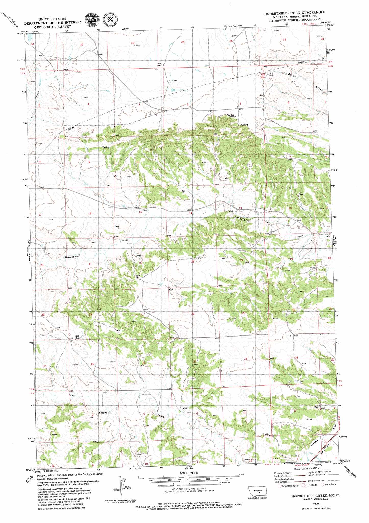
USGS Topo Quad 46108d6 - 1:24,000 scale
| Topo Map Name: | Horse Thief Creek |
| USGS Topo Quad ID: | 46108d6 |
| Print Size: | ca. 21 1/4" wide x 27" high |
| Southeast Coordinates: | 46.375° N latitude / 108.625° W longitude |
| Map Center Coordinates: | 46.4375° N latitude / 108.6875° W longitude |
| U.S. State: | MT |
| Filename: | o46108d6.jpg |
| Download Map JPG Image: | Horse Thief Creek topo map 1:24,000 scale |
| Map Type: | Topographic |
| Topo Series: | 7.5´ |
| Map Scale: | 1:24,000 |
| Source of Map Images: | United States Geological Survey (USGS) |
| Alternate Map Versions: |
Horsethief Creek MT 1979, updated 1980 Download PDF Buy paper map Horsethief Creek MT 2011 Download PDF Buy paper map Horsethief Creek MT 2014 Download PDF Buy paper map |
1:24,000 Topo Quads surrounding Horse Thief Creek
Devils Hole Lake |
Pender Coulee |
Lake Mason Nw |
Lake Mason Ne |
Big Wall Nw |
Emory School |
Timber Buttes North |
Lake Mason |
Lake Mason Se |
Big Wall West |
Lavina Nw |
Timber Buttes South |
Horse Thief Creek |
Roundup |
Gage |
Lavina |
Bundy |
Elso |
Harper Coulee |
Signal Mountain |
Belmont |
Broadview Ne |
Hay Basin North |
Hay Basin Ne |
Park Coulee |
> Back to 46108a1 at 1:100,000 scale
> Back to 46108a1 at 1:250,000 scale
> Back to U.S. Topo Maps home
Horse Thief Creek topo map: Gazetteer
Horse Thief Creek: Canals
Naderman Ditch elevation 994m 3261′Horse Thief Creek: Wells
07N24E02BCDA01 Well elevation 1014m 3326′07N24E04BBBC01 Well elevation 1023m 3356′
07N25E06ADDD01 Well elevation 1000m 3280′
08N24E02C___01 Well elevation 1128m 3700′
08N24E15ACCC01 Well elevation 1026m 3366′
08N24E15CCBB01 Well elevation 1040m 3412′
08N24E17ADD_01 Well elevation 1072m 3517′
08N24E17ADDB01 Well elevation 1071m 3513′
08N24E20ACBA01 Well elevation 1032m 3385′
08N24E33BB__01 Well elevation 1057m 3467′
08N25E06BBAD01 Well elevation 1112m 3648′
08N25E20BBAD01 Well elevation 1003m 3290′
Horse Thief Creek digital topo map on disk
Buy this Horse Thief Creek topo map showing relief, roads, GPS coordinates and other geographical features, as a high-resolution digital map file on DVD: