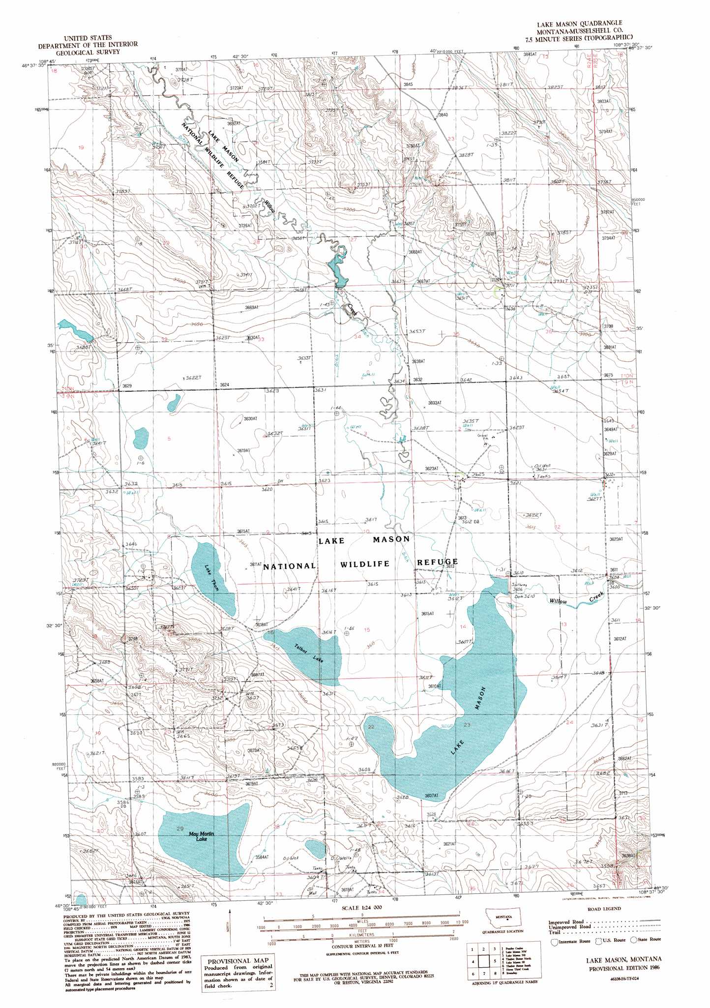
Lake Mason Topo Map Montana
To zoom in, hover over the map of Lake Mason
USGS Topo Quad 46108e6 - 1:24,000 scale
| Topo Map Name: | Lake Mason |
| USGS Topo Quad ID: | 46108e6 |
| Print Size: | ca. 21 1/4" wide x 27" high |
| Southeast Coordinates: | 46.5° N latitude / 108.625° W longitude |
| Map Center Coordinates: | 46.5625° N latitude / 108.6875° W longitude |
| U.S. State: | MT |
| Filename: | o46108e6.jpg |
| Download Map JPG Image: | Lake Mason topo map 1:24,000 scale |
| Map Type: | Topographic |
| Topo Series: | 7.5´ |
| Map Scale: | 1:24,000 |
| Source of Map Images: | United States Geological Survey (USGS) |
| Alternate Map Versions: |
Lake Mason MT 1986, updated 1986 Download PDF Buy paper map Lake Mason MT 2011 Download PDF Buy paper map Lake Mason MT 2014 Download PDF Buy paper map |
1:24,000 Topo Quads surrounding Lake Mason
Bald Butte |
Tyler |
Pike Creek Hills W. |
Pike Creek Hills E. |
Flatwillow |
Devils Hole Lake |
Pender Coulee |
Lake Mason Nw |
Lake Mason Ne |
Big Wall Nw |
Emory School |
Timber Buttes North |
Lake Mason |
Lake Mason Se |
Big Wall West |
Lavina Nw |
Timber Buttes South |
Horse Thief Creek |
Roundup |
Gage |
Lavina |
Bundy |
Elso |
Harper Coulee |
Signal Mountain |
> Back to 46108e1 at 1:100,000 scale
> Back to 46108a1 at 1:250,000 scale
> Back to U.S. Topo Maps home
Lake Mason topo map: Gazetteer
Lake Mason: Dams
Ernie Number 1 Dam elevation 1118m 3667′Lake Mason National Wildlife Refuge Dam elevation 1100m 3608′
Lake Mason: Lakes
Lake Thom elevation 1100m 3608′May Martin Lake elevation 1093m 3585′
Talbot Lake elevation 1102m 3615′
Lake Mason: Reservoirs
Lake Mason elevation 1101m 3612′Lake Mason: Wells
09N24E08BBBD01 Well elevation 1107m 3631′09N25E06CCCA01 Well elevation 1107m 3631′
10N24E29D___01 Well elevation 1136m 3727′
10N24E32D___01 Well elevation 1106m 3628′
Lake Mason digital topo map on disk
Buy this Lake Mason topo map showing relief, roads, GPS coordinates and other geographical features, as a high-resolution digital map file on DVD: