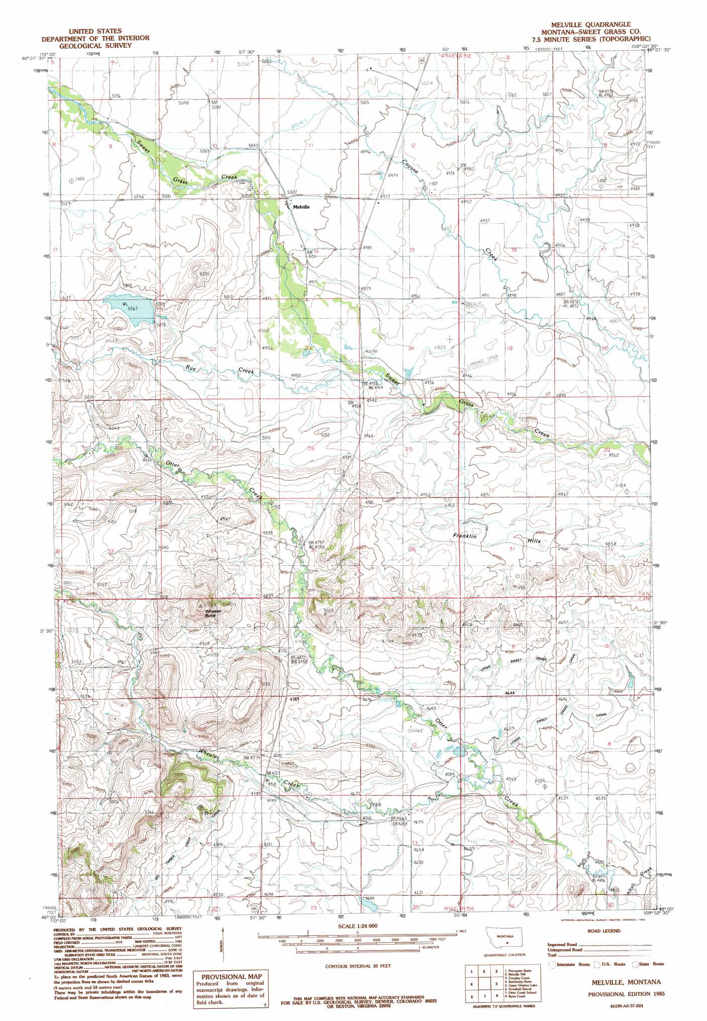
Melville Topo Map Montana
To zoom in, hover over the map of Melville
USGS Topo Quad 46109a8 - 1:24,000 scale
| Topo Map Name: | Melville |
| USGS Topo Quad ID: | 46109a8 |
| Print Size: | ca. 21 1/4" wide x 27" high |
| Southeast Coordinates: | 46° N latitude / 109.875° W longitude |
| Map Center Coordinates: | 46.0625° N latitude / 109.9375° W longitude |
| U.S. State: | MT |
| Filename: | o46109a8.jpg |
| Download Map JPG Image: | Melville topo map 1:24,000 scale |
| Map Type: | Topographic |
| Topo Series: | 7.5´ |
| Map Scale: | 1:24,000 |
| Source of Map Images: | United States Geological Survey (USGS) |
| Alternate Map Versions: |
Melville MT 1985, updated 1985 Download PDF Buy paper map Melville MT 2011 Download PDF Buy paper map Melville MT 2014 Download PDF Buy paper map |
1:24,000 Topo Quads surrounding Melville
Cinnamon Spring |
Lebo Lake |
Harlowton Sw |
Ten O'Clock Gate |
Devils Pocket |
Rein Lake |
Porcupine Butte |
Melville Nw |
Gougley Creek |
Jim Creek |
Amelong Creek |
Battleship Butte |
Melville |
Upper Glaston Lake |
Gibson Sw |
Raspberry Butte |
Grosfield Ranch |
Otter Creek School |
Ryan Creek |
Sourdough School |
Kelly Hills |
Carney |
Big Timber |
Greycliff |
Lone Indian Butte |
> Back to 46109a1 at 1:100,000 scale
> Back to 46108a1 at 1:250,000 scale
> Back to U.S. Topo Maps home
Melville topo map: Gazetteer
Melville: Canals
Upper Sweet Grass Canal elevation 1429m 4688′Melville: Dams
Cramer Dam elevation 1554m 5098′Melville: Populated Places
Melville elevation 1529m 5016′Norwegian Settlement (historical) elevation 1546m 5072′
Melville: Post Offices
Glasston Post Office (historical) elevation 1368m 4488′Melville Post Office elevation 1529m 5016′
Puett Post Office (historical) elevation 1521m 4990′
Melville: Ranges
Franklin Hills elevation 1487m 4878′Melville: Streams
Alkali Creek elevation 1364m 4475′Rye Creek elevation 1502m 4927′
Wheeler Creek elevation 1402m 4599′
Melville: Summits
Wheeler Butte elevation 1512m 4960′Melville: Wells
03N14E09DCC_01 Well elevation 1524m 5000′03N15E08____01 Well elevation 1401m 4596′
03N15E17____01 Well elevation 1378m 4520′
04N14E14BA__01 Well elevation 1530m 5019′
04N14E15____01 Well elevation 1566m 5137′
04N15E17____01 Well elevation 1501m 4924′
Melville digital topo map on disk
Buy this Melville topo map showing relief, roads, GPS coordinates and other geographical features, as a high-resolution digital map file on DVD: