Ryegate West Topo Map Montana
To zoom in, hover over the map of Ryegate West
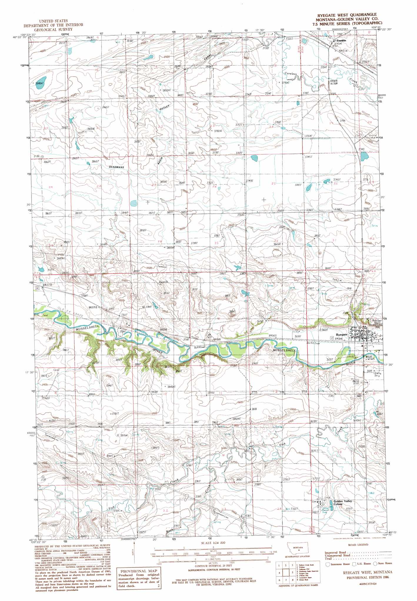
USGS Topo Quad 46109c3 - 1:24,000 scale
| Topo Map Name: | Ryegate West |
| USGS Topo Quad ID: | 46109c3 |
| Print Size: | ca. 21 1/4" wide x 27" high |
| Southeast Coordinates: | 46.25° N latitude / 109.25° W longitude |
| Map Center Coordinates: | 46.3125° N latitude / 109.3125° W longitude |
| U.S. State: | MT |
| Filename: | o46109c3.jpg |
| Download Map JPG Image: | Ryegate West topo map 1:24,000 scale |
| Map Type: | Topographic |
| Topo Series: | 7.5´ |
| Map Scale: | 1:24,000 |
| Source of Map Images: | United States Geological Survey (USGS) |
| Alternate Map Versions: |
Ryegate West MT 1986, updated 1986 Download PDF Buy paper map Ryegate West MT 2011 Download PDF Buy paper map Ryegate West MT 2014 Download PDF Buy paper map |
1:24,000 Topo Quads surrounding Ryegate West
Nihill |
Halbert Creek North |
Rothiemay |
Sahara Hill Sw |
Sahara Hill Se |
Hedgesville |
Halbert Creek South |
Vallum |
Cushman Nw |
Cushman Ne |
Shawmut |
Deadman Basin Res. |
Ryegate West |
Ryegate East |
Cushman |
Progress |
O'Brien Hill |
Locomotive Butte |
Mount Sinai |
Eagle Point |
Gibson |
Locomotive Butte Sw |
Locomotive Butte Se |
Hailstone Basin |
Hailstone Basin Se |
> Back to 46109a1 at 1:100,000 scale
> Back to 46108a1 at 1:250,000 scale
> Back to U.S. Topo Maps home
Ryegate West topo map: Gazetteer
Ryegate West: Airports
Ryegate Airport elevation 1112m 3648′Ryegate West: Canals
Deadmans Basin Outlet Canal elevation 1181m 3874′Ryegate West: Dams
Stella Number 1 Dam elevation 1145m 3756′Ryegate West: Parks
Ryegate City Park elevation 1114m 3654′Ryegate West: Populated Places
Dodgetown (historical) elevation 1133m 3717′Franklin elevation 1140m 3740′
Golden Valley Colony elevation 1155m 3789′
Ryegate elevation 1113m 3651′
Ryegate West: Post Offices
Dodgeton Post Office (historical) elevation 1133m 3717′Franklin Post Office (historical) elevation 1139m 3736′
Ryegate Post Office elevation 1113m 3651′
Ryegate West: Streams
Rock Creek elevation 1130m 3707′Ryegate West: Wells
06N19E01BCCC01 Well elevation 1135m 3723′06N19E23BCDB01 Well elevation 1157m 3795′
06N20E05DA__01 Well elevation 1114m 3654′
06N20E06ADA_01 Well elevation 1182m 3877′
06N20E20BBC_01 Well elevation 1141m 3743′
Ryegate West digital topo map on disk
Buy this Ryegate West topo map showing relief, roads, GPS coordinates and other geographical features, as a high-resolution digital map file on DVD: