Sahara Hill Topo Map Montana
To zoom in, hover over the map of Sahara Hill
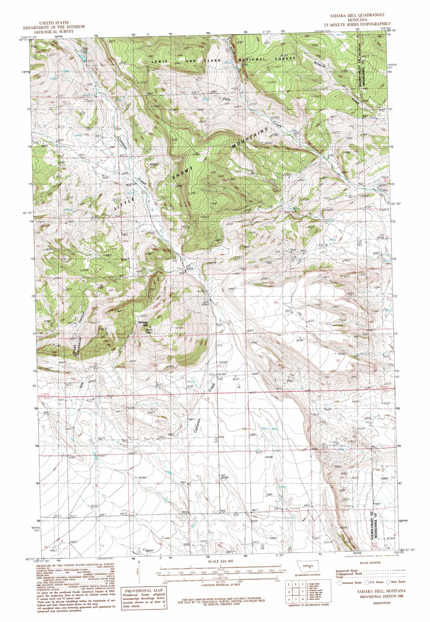
USGS Topo Quad 46109f1 - 1:24,000 scale
| Topo Map Name: | Sahara Hill |
| USGS Topo Quad ID: | 46109f1 |
| Print Size: | ca. 21 1/4" wide x 27" high |
| Southeast Coordinates: | 46.625° N latitude / 109° W longitude |
| Map Center Coordinates: | 46.6875° N latitude / 109.0625° W longitude |
| U.S. State: | MT |
| Filename: | o46109f1.jpg |
| Download Map JPG Image: | Sahara Hill topo map 1:24,000 scale |
| Map Type: | Topographic |
| Topo Series: | 7.5´ |
| Map Scale: | 1:24,000 |
| Source of Map Images: | United States Geological Survey (USGS) |
| Alternate Map Versions: |
Sahara Hill MT 1986, updated 1986 Download PDF Buy paper map Sahara Hill MT 1995, updated 1997 Download PDF Buy paper map Sahara Hill MT 2011 Download PDF Buy paper map Sahara Hill MT 2014 Download PDF Buy paper map |
| FStopo: | US Forest Service topo Sahara Hill is available: Download FStopo PDF Download FStopo TIF |
1:24,000 Topo Quads surrounding Sahara Hill
Heath |
Loco Ridge |
Forestgrove |
Becket |
Becket Ne |
Half Moon Canyon |
Alaska Bench |
South Bench |
Bald Butte |
Tyler |
Green Ashly Gulch |
Patterson Canyon |
Sahara Hill |
Devils Hole Lake |
Pender Coulee |
Rothiemay |
Sahara Hill Sw |
Sahara Hill Se |
Emory School |
Timber Buttes North |
Vallum |
Cushman Nw |
Cushman Ne |
Lavina Nw |
Timber Buttes South |
> Back to 46109e1 at 1:100,000 scale
> Back to 46108a1 at 1:250,000 scale
> Back to U.S. Topo Maps home
Sahara Hill topo map: Gazetteer
Sahara Hill: Post Offices
Clara Post Office (historical) elevation 1427m 4681′Rayfield Post Office (historical) elevation 1367m 4484′
Sahara Hill: Streams
North Fork Pole Creek elevation 1440m 4724′Ray Creek elevation 1405m 4609′
South Fork Pole Creek elevation 1440m 4724′
Sahara Hill: Summits
Sahara Hill elevation 1628m 5341′Sahara Hill: Valleys
Stonehouse Canyon elevation 1443m 4734′Sahara Hill digital topo map on disk
Buy this Sahara Hill topo map showing relief, roads, GPS coordinates and other geographical features, as a high-resolution digital map file on DVD: