Amelong Creek Topo Map Montana
To zoom in, hover over the map of Amelong Creek
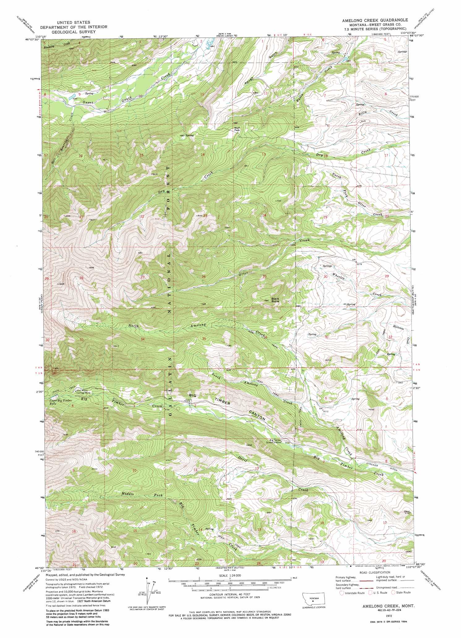
USGS Topo Quad 46110a2 - 1:24,000 scale
| Topo Map Name: | Amelong Creek |
| USGS Topo Quad ID: | 46110a2 |
| Print Size: | ca. 21 1/4" wide x 27" high |
| Southeast Coordinates: | 46° N latitude / 110.125° W longitude |
| Map Center Coordinates: | 46.0625° N latitude / 110.1875° W longitude |
| U.S. State: | MT |
| Filename: | o46110a2.jpg |
| Download Map JPG Image: | Amelong Creek topo map 1:24,000 scale |
| Map Type: | Topographic |
| Topo Series: | 7.5´ |
| Map Scale: | 1:24,000 |
| Source of Map Images: | United States Geological Survey (USGS) |
| Alternate Map Versions: |
Amelong Creek MT 1972, updated 1976 Download PDF Buy paper map Amelong Creek MT 1972, updated 1986 Download PDF Buy paper map Amelong Creek MT 2000, updated 2005 Download PDF Buy paper map Amelong Creek MT 2011 Download PDF Buy paper map Amelong Creek MT 2014 Download PDF Buy paper map |
| FStopo: | US Forest Service topo Amelong Creek is available: Download FStopo PDF Download FStopo TIF |
1:24,000 Topo Quads surrounding Amelong Creek
Lebo |
Cinnamon Peak |
Cinnamon Spring |
Lebo Lake |
Harlowton Sw |
Virginia Peak |
Loco Mountain |
Rein Lake |
Porcupine Butte |
Melville Nw |
Campfire Lake |
Crazy Peak |
Amelong Creek |
Battleship Butte |
Melville |
Ibex Mountain |
Fairview Peak |
Raspberry Butte |
Grosfield Ranch |
Otter Creek School |
Grannis |
Hunters Hot Springs |
Kelly Hills |
Carney |
Big Timber |
> Back to 46110a1 at 1:100,000 scale
> Back to 46110a1 at 1:250,000 scale
> Back to U.S. Topo Maps home
Amelong Creek topo map: Gazetteer
Amelong Creek: Airports
Langhus Airstrip elevation 1873m 6145′Amelong Creek: Falls
Upper Big Timber Falls elevation 2039m 6689′Amelong Creek: Flats
Wolf Park elevation 2201m 7221′Amelong Creek: Streams
Amelong Creek elevation 1691m 5547′Bruin Creek elevation 1849m 6066′
Hell Roaring Creek elevation 1842m 6043′
North Amelong Creek elevation 1820m 5971′
North Fork Otter Creek elevation 1796m 5892′
South Amelong Creek elevation 1820m 5971′
Amelong Creek: Summits
Black Butte elevation 2340m 7677′Amelong Creek: Valleys
Big Timber Canyon elevation 1679m 5508′Amelong Creek digital topo map on disk
Buy this Amelong Creek topo map showing relief, roads, GPS coordinates and other geographical features, as a high-resolution digital map file on DVD: