Lebo Topo Map Montana
To zoom in, hover over the map of Lebo
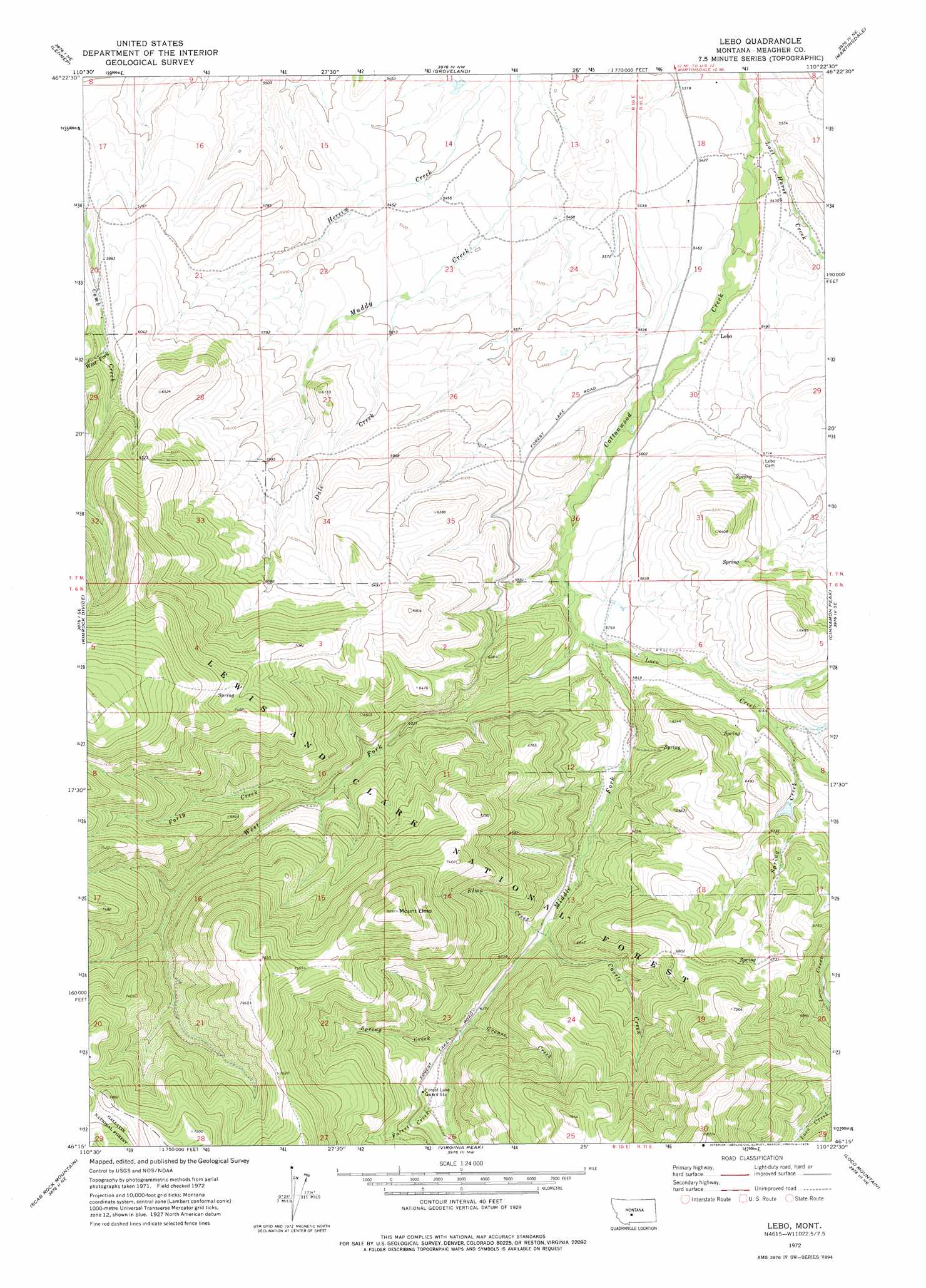
USGS Topo Quad 46110c4 - 1:24,000 scale
| Topo Map Name: | Lebo |
| USGS Topo Quad ID: | 46110c4 |
| Print Size: | ca. 21 1/4" wide x 27" high |
| Southeast Coordinates: | 46.25° N latitude / 110.375° W longitude |
| Map Center Coordinates: | 46.3125° N latitude / 110.4375° W longitude |
| U.S. State: | MT |
| Filename: | o46110c4.jpg |
| Download Map JPG Image: | Lebo topo map 1:24,000 scale |
| Map Type: | Topographic |
| Topo Series: | 7.5´ |
| Map Scale: | 1:24,000 |
| Source of Map Images: | United States Geological Survey (USGS) |
| Alternate Map Versions: |
Lebo MT 1972, updated 1976 Download PDF Buy paper map Lebo MT 1995, updated 1997 Download PDF Buy paper map Lebo MT 2011 Download PDF Buy paper map Lebo MT 2014 Download PDF Buy paper map |
| FStopo: | US Forest Service topo Lebo is available: Download FStopo PDF Download FStopo TIF |
1:24,000 Topo Quads surrounding Lebo
Fourmile Spring |
Checkerboard |
Mount Howe |
Mud Creek |
Haymaker Ranch Sw |
Castle Town |
Lennep |
Groveland |
Martinsdale |
Twodot Nw |
Hamen |
Rimrock Divide |
Lebo |
Cinnamon Peak |
Cinnamon Spring |
Wolf Hill |
Scab Rock Mountain |
Virginia Peak |
Loco Mountain |
Rein Lake |
Cotttonwood Reservoir |
Lena Creek |
Campfire Lake |
Crazy Peak |
Amelong Creek |
> Back to 46110a1 at 1:100,000 scale
> Back to 46110a1 at 1:250,000 scale
> Back to U.S. Topo Maps home
Lebo topo map: Gazetteer
Lebo: Dams
Crazy Sombreo Dam elevation 1888m 6194′Lebo: Populated Places
Lebo elevation 1673m 5488′Lebo: Post Offices
Lebo Post Office (historical) elevation 1673m 5488′Lebo: Streams
Castle Creek elevation 1839m 6033′Dale Creek elevation 1691m 5547′
Elmo Creek elevation 1837m 6026′
Forest Creek elevation 1909m 6263′
Forty Creek elevation 1871m 6138′
Grouse Creek elevation 1883m 6177′
Loco Creek elevation 1739m 5705′
Lost Horse Creek elevation 1625m 5331′
Middle Fork Cottonwood Creek elevation 1738m 5702′
Spring Creek elevation 1883m 6177′
Spring Creek elevation 1828m 5997′
West Fork Comb Creek elevation 1800m 5905′
West Fork Cottonwood Creek elevation 1738m 5702′
Lebo: Summits
Mount Elmo elevation 2470m 8103′Lebo: Wells
06N11E06B___01 Well elevation 1796m 5892′06N11E06D___01 Well elevation 1826m 5990′
07N11E29____01 Well elevation 1707m 5600′
Lebo digital topo map on disk
Buy this Lebo topo map showing relief, roads, GPS coordinates and other geographical features, as a high-resolution digital map file on DVD: