Castle Town Topo Map Montana
To zoom in, hover over the map of Castle Town
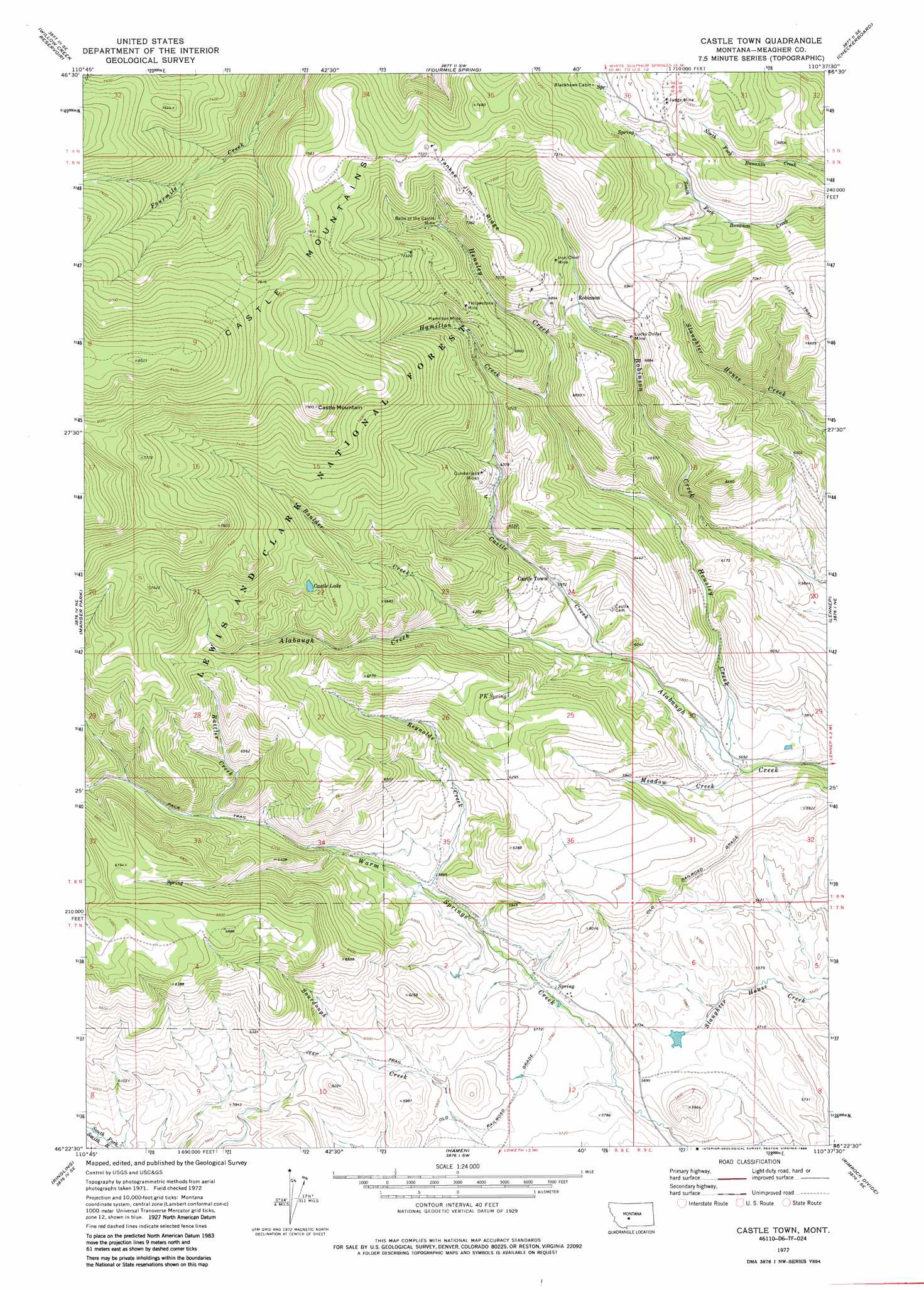
USGS Topo Quad 46110d6 - 1:24,000 scale
| Topo Map Name: | Castle Town |
| USGS Topo Quad ID: | 46110d6 |
| Print Size: | ca. 21 1/4" wide x 27" high |
| Southeast Coordinates: | 46.375° N latitude / 110.625° W longitude |
| Map Center Coordinates: | 46.4375° N latitude / 110.6875° W longitude |
| U.S. State: | MT |
| Filename: | o46110d6.jpg |
| Download Map JPG Image: | Castle Town topo map 1:24,000 scale |
| Map Type: | Topographic |
| Topo Series: | 7.5´ |
| Map Scale: | 1:24,000 |
| Source of Map Images: | United States Geological Survey (USGS) |
| Alternate Map Versions: |
Castle Town MT 1972, updated 1986 Download PDF Buy paper map Castle Town MT 1995, updated 1997 Download PDF Buy paper map Castle Town MT 1995, updated 1997 Download PDF Buy paper map Castle Town MT 2011 Download PDF Buy paper map Castle Town MT 2014 Download PDF Buy paper map |
| FStopo: | US Forest Service topo Castle Town is available: Download FStopo PDF Download FStopo TIF |
1:24,000 Topo Quads surrounding Castle Town
Coxcombe Butte |
Charcoal Gulch |
Volcano Butte |
Hoover Spring |
Russian Flat |
White Sulphur Springs |
Pinchout Creek |
Fourmile Spring |
Checkerboard |
Mount Howe |
Catlin Spring |
Manger Park |
Castle Town |
Lennep |
Groveland |
Black Butte Mountain |
Ringling |
Hamen |
Rimrock Divide |
Lebo |
Sixteen |
Sixteen Ne |
Wolf Hill |
Scab Rock Mountain |
Virginia Peak |
> Back to 46110a1 at 1:100,000 scale
> Back to 46110a1 at 1:250,000 scale
> Back to U.S. Topo Maps home
Castle Town topo map: Gazetteer
Castle Town: Dams
Grande Dam elevation 1733m 5685′Castle Town: Lakes
Castle Lake elevation 2098m 6883′Castle Town: Mines
Belle of the Castle Mine elevation 2099m 6886′Bond Holder Mine elevation 2091m 6860′
Broadway Mine elevation 1956m 6417′
California Mine elevation 2080m 6824′
Compromise Mine elevation 2091m 6860′
Cornelius Stone Placer Mine elevation 1875m 6151′
Cumberland Mine elevation 1967m 6453′
Cumberland Mines elevation 1976m 6482′
Golden Eagle Mine elevation 2236m 7335′
Great Western Mine elevation 2049m 6722′
Hamilton Mine elevation 2068m 6784′
Hidden Treasure Mine elevation 2123m 6965′
Hillside Mine elevation 2026m 6646′
Homestake Mine elevation 2095m 6873′
Iron Chief Mine elevation 2102m 6896′
Judge Mine elevation 2159m 7083′
Lamar Mine elevation 2149m 7050′
Legal Tender Mine elevation 2129m 6984′
Lucky Dollar Mine elevation 2016m 6614′
Morning Star Mine elevation 2177m 7142′
NE NE Section 11 Mine elevation 2106m 6909′
NW NW Section 27 Mine elevation 2109m 6919′
NW SE Section 11 Mine elevation 2034m 6673′
SE NE Section 11 Mine elevation 2104m 6902′
SE SE Section 11 Mine elevation 2039m 6689′
SE SE Section 22 Mine elevation 1973m 6473′
SE SW Section 2 Mine elevation 2192m 7191′
SE SW Section 34 Mine elevation 2343m 7687′
Silver Star Mine elevation 2061m 6761′
Solid Silver Mine elevation 2074m 6804′
SW NE Section 2 Mine elevation 2194m 7198′
SW SW Section 2 Mine elevation 2206m 7237′
SW SW Section 35 Mine elevation 2312m 7585′
SW SW Section 36 Mine elevation 2261m 7417′
Yellowstone Mine elevation 2131m 6991′
Yellowstone Mine elevation 2137m 7011′
Castle Town: Populated Places
Castle Town elevation 1822m 5977′Robinson elevation 2041m 6696′
Castle Town: Post Offices
Blackhawk Post Office (historical) elevation 2079m 6820′Castle Post Office (historical) elevation 1822m 5977′
Leadboro Post Office (historical) elevation 1744m 5721′
Robinson Post Office (historical) elevation 2041m 6696′
Castle Town: Ridges
Yankee Jim Ridge elevation 2260m 7414′Castle Town: Springs
P K Spring elevation 1946m 6384′Castle Town: Streams
Boulder Creek elevation 1836m 6023′Castle Creek elevation 1772m 5813′
Hamilton Creek elevation 1934m 6345′
Hensley Creek elevation 1731m 5679′
Meadow Creek elevation 1729m 5672′
Rattler Creek elevation 1859m 6099′
Reynolds Creek elevation 1783m 5849′
Castle Town: Summits
Castle Mountain elevation 2429m 7969′Castle Town digital topo map on disk
Buy this Castle Town topo map showing relief, roads, GPS coordinates and other geographical features, as a high-resolution digital map file on DVD: