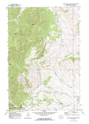
Woodhurst Mountain Topo Map Montana
To zoom in, hover over the map of Woodhurst Mountain
USGS Topo Quad 46110h3 - 1:24,000 scale
| Topo Map Name: | Woodhurst Mountain |
| USGS Topo Quad ID: | 46110h3 |
| Print Size: | ca. 21 1/4" wide x 27" high |
| Southeast Coordinates: | 46.875° N latitude / 110.25° W longitude |
| Map Center Coordinates: | 46.9375° N latitude / 110.3125° W longitude |
| U.S. State: | MT |
| Filename: | o46110h3.jpg |
| Download Map JPG Image: | Woodhurst Mountain topo map 1:24,000 scale |
| Map Type: | Topographic |
| Topo Series: | 7.5´ |
| Map Scale: | 1:24,000 |
| Source of Map Images: | United States Geological Survey (USGS) |
| Alternate Map Versions: |
Woodhurst Mountain MT 1970, updated 1973 Download PDF Buy paper map Woodhurst Mountain MT 1970, updated 1973 Download PDF Buy paper map Woodhurst Mountain MT 1995, updated 1997 Download PDF Buy paper map Woodhurst Mountain MT 2011 Download PDF Buy paper map Woodhurst Mountain MT 2014 Download PDF Buy paper map |
| FStopo: | US Forest Service topo Woodhurst Mountain is available: Download FStopo PDF Download FStopo TIF |
1:24,000 Topo Quads surrounding Woodhurst Mountain
> Back to 46110e1 at 1:100,000 scale
> Back to 46110a1 at 1:250,000 scale
> Back to U.S. Topo Maps home
Woodhurst Mountain topo map: Gazetteer
Woodhurst Mountain: Mines
NE NE Section 8 Mine elevation 1715m 5626′NW SE Section 6 Mine elevation 2046m 6712′
Saphire Mine elevation 1593m 5226′
SE SE Section 6 Mine elevation 1937m 6354′
Woodhurst Mountain: Parks
Judith River State Wildlife Management Area elevation 1579m 5180′Woodhurst Mountain: Populated Places
Sapphire Village elevation 1492m 4895′Woodhurst Mountain: Springs
14N11E12AD__01 Spring elevation 1692m 5551′14N11E13AA__01 Spring elevation 1673m 5488′
14N11E13DD__01 Spring elevation 1613m 5291′
14N11E22BC__01 Spring elevation 1768m 5800′
14N11E23DC__01 Spring elevation 1676m 5498′
14N11E23DC__02 Spring elevation 1676m 5498′
14N11E23DC__03 Spring elevation 1676m 5498′
14N11E24BC__01 Spring elevation 1631m 5351′
14N11E24CA__01 Spring elevation 1599m 5246′
14N11E24CA__02 Spring elevation 1599m 5246′
14N11E25BC__01 Spring elevation 1716m 5629′
14N11E25DA__01 Spring elevation 1809m 5935′
14N11E25DA__02 Spring elevation 1809m 5935′
14N11E26BD__01 Spring elevation 1720m 5643′
14N11E26CB__01 Spring elevation 1783m 5849′
14N11E26CC__01 Spring elevation 1827m 5994′
14N11E26DB__01 Spring elevation 1740m 5708′
14N11E26DB__02 Spring elevation 1740m 5708′
14N11E26DB__03 Spring elevation 1740m 5708′
14N11E33BC__01 Spring elevation 1938m 6358′
14N11E34DB__01 Spring elevation 1732m 5682′
14N11E35BD__01 Spring elevation 1687m 5534′
14N11E36CA__01 Spring elevation 1807m 5928′
14N12E07BC__01 Spring elevation 1695m 5561′
14N12E19BB__01 Spring elevation 1590m 5216′
14N12E19BC__02 Spring elevation 1578m 5177′
14N12E30BB__01 Spring elevation 1737m 5698′
Mitchell Spring elevation 1934m 6345′
Woodhurst Mountain: Summits
Marys Knoll elevation 1903m 6243′Reed Hill elevation 1992m 6535′
Tepee Butte elevation 2026m 6646′
Woodhurst Mountain elevation 2250m 7381′
Woodhurst Mountain: Valleys
Hay Coulee elevation 1721m 5646′Mitchell Gulch elevation 1749m 5738′
Moose Coulee elevation 1649m 5410′
Rickard Coulee elevation 1627m 5337′
Sawmill Gulch elevation 1652m 5419′
Woodhurst Mountain: Wells
13N11E02AB__01 Well elevation 1630m 5347′13N11E11BC__01 Well elevation 1623m 5324′
13N11E11DC__01 Well elevation 1554m 5098′
13N11E13AD__01 Well elevation 1504m 4934′
13N11E14BC__01 Well elevation 1560m 5118′
13N11E14CC__01 Well elevation 1562m 5124′
13N11E14CC__02 Well elevation 1562m 5124′
13N11E14DD__01 Well elevation 1526m 5006′
13N11E15AB__01 Well elevation 1590m 5216′
13N11E15BA__01 Well elevation 1590m 5216′
13N11E16CA__01 Well elevation 1657m 5436′
13N11E16CA__02 Well elevation 1657m 5436′
14N11E04CD__01 Well elevation 1794m 5885′
14N12E19BC__01 Well elevation 1578m 5177′
Woodhurst Mountain digital topo map on disk
Buy this Woodhurst Mountain topo map showing relief, roads, GPS coordinates and other geographical features, as a high-resolution digital map file on DVD:


