Band Box Mountain Topo Map Montana
To zoom in, hover over the map of Band Box Mountain
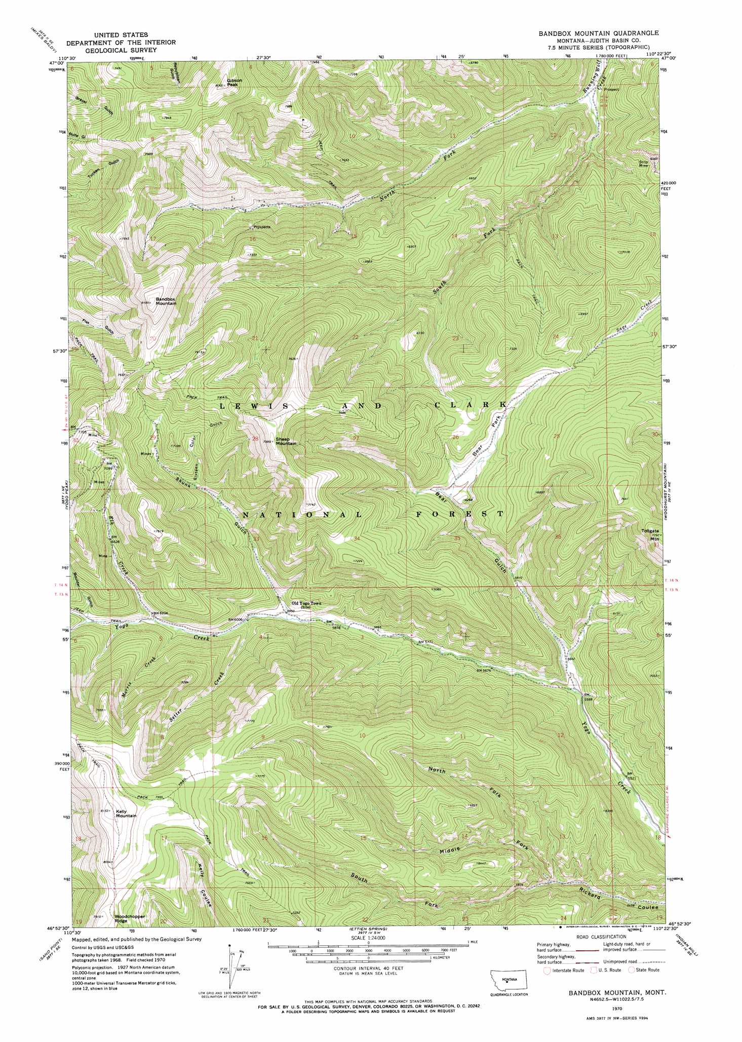
USGS Topo Quad 46110h4 - 1:24,000 scale
| Topo Map Name: | Band Box Mountain |
| USGS Topo Quad ID: | 46110h4 |
| Print Size: | ca. 21 1/4" wide x 27" high |
| Southeast Coordinates: | 46.875° N latitude / 110.375° W longitude |
| Map Center Coordinates: | 46.9375° N latitude / 110.4375° W longitude |
| U.S. State: | MT |
| Filename: | o46110h4.jpg |
| Download Map JPG Image: | Band Box Mountain topo map 1:24,000 scale |
| Map Type: | Topographic |
| Topo Series: | 7.5´ |
| Map Scale: | 1:24,000 |
| Source of Map Images: | United States Geological Survey (USGS) |
| Alternate Map Versions: |
Bandbox Mountain MT 1970, updated 1973 Download PDF Buy paper map Bandbox Mountain MT 1970, updated 1986 Download PDF Buy paper map Bandbox Mountain MT 2011 Download PDF Buy paper map Bandbox Mountain MT 2014 Download PDF Buy paper map |
| FStopo: | US Forest Service topo Bandbox Mountain is available: Download FStopo PDF Download FStopo TIF |
1:24,000 Topo Quads surrounding Band Box Mountain
Limestone Butte |
The Arch |
Wolf Butte Nw |
Merino |
Stanford |
Barker |
Mixes Baldy |
Wolf Butte |
Cayuse Basin |
Windham |
Neihart |
Yogo Peak |
Band Box Mountain |
Woodhurst Mountain |
Red Hill |
Kings Hill |
Sand Point |
Ettien Spring |
Indian Hill |
Browns Canyon |
Volcano Butte |
Hoover Spring |
Russian Flat |
Daisy Peak |
Haymaker Narrows |
> Back to 46110e1 at 1:100,000 scale
> Back to 46110a1 at 1:250,000 scale
> Back to U.S. Topo Maps home
Band Box Mountain topo map: Gazetteer
Band Box Mountain: Flats
Bear Park elevation 1934m 6345′Band Box Mountain: Gaps
Elk Saddle elevation 2357m 7732′Band Box Mountain: Mines
Gold Bug Mine elevation 2049m 6722′NE NE Section 12 Mine elevation 1935m 6348′
NE NE Section 31 Mine elevation 2120m 6955′
NE NW Section 16 Mine elevation 1921m 6302′
NW NE Section 16 Mine elevation 1879m 6164′
NW NW Section 14 Mine elevation 1885m 6184′
NW SW Section 32 Mine elevation 2010m 6594′
Old Yogo Townsite Mine elevation 1833m 6013′
Running Wolf Deposit Mine elevation 2122m 6961′
SE NE Section 30 Mine elevation 2309m 7575′
SE NW Section 16 Mine elevation 2041m 6696′
Skunk Gulch Placer Mine elevation 1828m 5997′
SW NW Section 10 Mine elevation 2293m 7522′
SW NW Section 15 Mine elevation 1888m 6194′
SW SE Section 29 Mine elevation 2040m 6692′
SW SE Section 33 Mine elevation 1853m 6079′
Band Box Mountain: Populated Places
Cameron (historical) elevation 1726m 5662′Band Box Mountain: Post Offices
Hoover Post Office (historical) elevation 1839m 6033′Kalatta Post Office (historical) elevation 1832m 6010′
Yogo Post Office (historical) elevation 1838m 6030′
Band Box Mountain: Streams
Elk Creek elevation 1882m 6174′Morris Creek elevation 1868m 6128′
North Fork Running Wolf Creek elevation 1651m 5416′
Setter Creek elevation 1835m 6020′
South Fork Running Wolf Creek elevation 1651m 5416′
Band Box Mountain: Summits
Bandbox Mountain elevation 2468m 8097′Gibson Peak elevation 2455m 8054′
Kelly Mountain elevation 2483m 8146′
Sheep Mountain elevation 2438m 7998′
Tollgate Mountain elevation 2372m 7782′
Tucken Mountain elevation 2308m 7572′
Band Box Mountain: Valleys
Bear Gulch elevation 1703m 5587′Boulder Gulch elevation 1941m 6368′
Middle Fork Rickard Coulee elevation 1734m 5688′
North Fork Rickard Coulee elevation 1762m 5780′
Sixteen Color Gulch elevation 1958m 6423′
Skunk Gulch elevation 1815m 5954′
South Fork Rickard Coulee elevation 1734m 5688′
Band Box Mountain digital topo map on disk
Buy this Band Box Mountain topo map showing relief, roads, GPS coordinates and other geographical features, as a high-resolution digital map file on DVD: