Blacktail Mountain Topo Map Montana
To zoom in, hover over the map of Blacktail Mountain
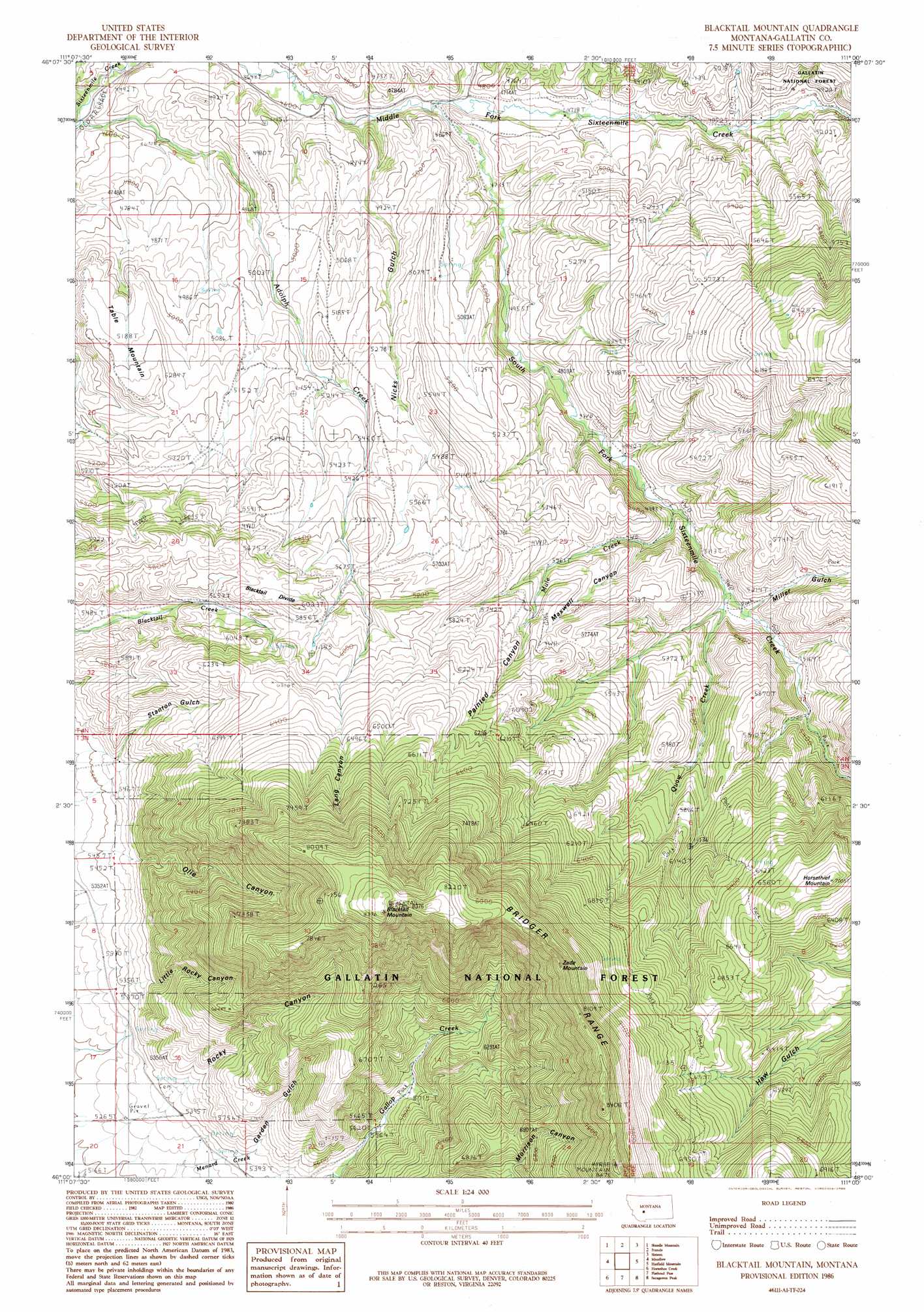
USGS Topo Quad 46111a1 - 1:24,000 scale
| Topo Map Name: | Blacktail Mountain |
| USGS Topo Quad ID: | 46111a1 |
| Print Size: | ca. 21 1/4" wide x 27" high |
| Southeast Coordinates: | 46° N latitude / 111° W longitude |
| Map Center Coordinates: | 46.0625° N latitude / 111.0625° W longitude |
| U.S. State: | MT |
| Filename: | o46111a1.jpg |
| Download Map JPG Image: | Blacktail Mountain topo map 1:24,000 scale |
| Map Type: | Topographic |
| Topo Series: | 7.5´ |
| Map Scale: | 1:24,000 |
| Source of Map Images: | United States Geological Survey (USGS) |
| Alternate Map Versions: |
Blacktail Mountain MT 1986, updated 1986 Download PDF Buy paper map Blacktail Mountain MT 2000, updated 2005 Download PDF Buy paper map Blacktail Mountain MT 2011 Download PDF Buy paper map Blacktail Mountain MT 2014 Download PDF Buy paper map |
| FStopo: | US Forest Service topo Blacktail Mountain is available: Download FStopo PDF Download FStopo TIF |
1:24,000 Topo Quads surrounding Blacktail Mountain
Lippert Gulch |
Sulphur Bar Creek |
Battle Mountain |
Black Butte Mountain |
Ringling |
Deer Park |
Sixmile Mountain |
Francis |
Sixteen |
Sixteen Ne |
Roy Gulch |
Maudlow |
Blacktail Mountain |
Hatfield Mountain |
Wallrock |
Nixon Gulch |
Horseshoe Creek |
Flathead Pass |
Sacagawea Peak |
Sedan |
Manhattan |
Belgrade |
Miser Creek |
Saddle Peak |
Grassy Mountain |
> Back to 46111a1 at 1:100,000 scale
> Back to 46110a1 at 1:250,000 scale
> Back to U.S. Topo Maps home
Blacktail Mountain topo map: Gazetteer
Blacktail Mountain: Ridges
Blacktail Divide elevation 1826m 5990′Blacktail Mountain: Streams
Adolph Creek elevation 1361m 4465′Mule Creek elevation 1524m 5000′
Quaw Creek elevation 1548m 5078′
South Fork Sixteenmile Creek elevation 1389m 4557′
Blacktail Mountain: Summits
Blacktail Mountain elevation 2551m 8369′Horsethief Mountain elevation 2121m 6958′
Table Mountain elevation 1611m 5285′
Zade Mountain elevation 2464m 8083′
Blacktail Mountain: Valleys
Garden Gulch elevation 1645m 5396′Lang Canyon elevation 1921m 6302′
Maxwell Canyon elevation 1607m 5272′
Miller Gulch elevation 1565m 5134′
Nicks Gulch elevation 1405m 4609′
Olie Canyon elevation 1699m 5574′
Painted Canyon elevation 1697m 5567′
Rocky Canyon elevation 1719m 5639′
Stanton Gulch elevation 1674m 5492′
Blacktail Mountain digital topo map on disk
Buy this Blacktail Mountain topo map showing relief, roads, GPS coordinates and other geographical features, as a high-resolution digital map file on DVD: