Toston Topo Map Montana
To zoom in, hover over the map of Toston
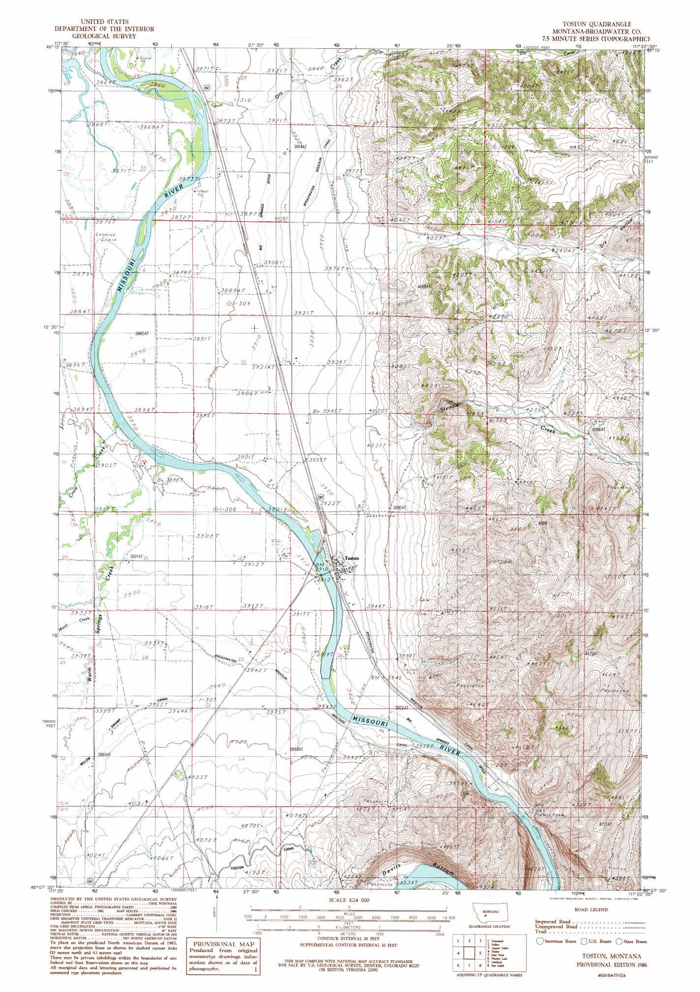
USGS Topo Quad 46111b4 - 1:24,000 scale
| Topo Map Name: | Toston |
| USGS Topo Quad ID: | 46111b4 |
| Print Size: | ca. 21 1/4" wide x 27" high |
| Southeast Coordinates: | 46.125° N latitude / 111.375° W longitude |
| Map Center Coordinates: | 46.1875° N latitude / 111.4375° W longitude |
| U.S. State: | MT |
| Filename: | o46111b4.jpg |
| Download Map JPG Image: | Toston topo map 1:24,000 scale |
| Map Type: | Topographic |
| Topo Series: | 7.5´ |
| Map Scale: | 1:24,000 |
| Source of Map Images: | United States Geological Survey (USGS) |
| Alternate Map Versions: |
Toston MT 1986, updated 1986 Download PDF Buy paper map Toston MT 1986, updated 1986 Download PDF Buy paper map Toston MT 2011 Download PDF Buy paper map Toston MT 2014 Download PDF Buy paper map |
1:24,000 Topo Quads surrounding Toston
Winston |
Townsend Ne |
Gurnett Creek West |
Gurnett Creek East |
Mount Edith |
Giant Hill |
Townsend |
Holker |
Lippert Gulch |
Sulphur Bar Creek |
Radersburg |
Parker |
Toston |
Deer Park |
Sixmile Mountain |
Radersburg Sw |
Plunket Lake |
Lombard |
Roy Gulch |
Maudlow |
Milligan Canyon |
Three Forks |
Logan |
Nixon Gulch |
Horseshoe Creek |
> Back to 46111a1 at 1:100,000 scale
> Back to 46110a1 at 1:250,000 scale
> Back to U.S. Topo Maps home
Toston topo map: Gazetteer
Toston: Bends
Devils Bottom elevation 1214m 3982′Toston: Bridges
Missouri River Bridge elevation 1189m 3900′Toston: Canals
Big Springs Ditch elevation 1195m 3920′Broadwater - Missouri Canal elevation 1202m 3943′
Lombard Canal elevation 1224m 4015′
Toston: Mines
Devils Bottom Mine elevation 1207m 3959′Toston Mine elevation 1305m 4281′
Toston: Populated Places
Brewer elevation 1206m 3956′Toston elevation 1194m 3917′
Toston: Post Offices
Toston Post Office elevation 1194m 3917′Toston Post Office (historical) elevation 1195m 3920′
Toston: Streams
Crow Creek elevation 1184m 3884′Dry Creek elevation 1184m 3884′
Marsh Creek elevation 1201m 3940′
Sixmile Creek elevation 1189m 3900′
Warm Springs Creek elevation 1199m 3933′
Toston: Tunnels
Toston Tunnel elevation 1283m 4209′Toston: Valleys
Dry Hollow elevation 1227m 4025′Toston: Wells
04N02E04AB__01 Well elevation 1232m 4041′04N02E04BC__01 Well elevation 1227m 4025′
05N02E02BB__01 Well elevation 1201m 3940′
05N02E02CB__01 Well elevation 1200m 3937′
05N02E03AC__01 Well elevation 1191m 3907′
05N02E03ACDC01 Well elevation 1192m 3910′
05N02E03DA__01 Well elevation 1195m 3920′
05N02E03DA__02 Well elevation 1195m 3920′
05N02E04DB__01 Well elevation 1183m 3881′
05N02E04DBDA01 Well elevation 1184m 3884′
05N02E09CA__01 Well elevation 1185m 3887′
05N02E10AD__01 Well elevation 1195m 3920′
05N02E10ADDD01 Well elevation 1197m 3927′
05N02E10CBCC01 Well elevation 1189m 3900′
05N02E10DA__01 Well elevation 1196m 3923′
05N02E11BC__01 Well elevation 1198m 3930′
05N02E14DD__01 Well elevation 1213m 3979′
05N02E15AC__01 Well elevation 1192m 3910′
05N02E15DA__01 Well elevation 1193m 3914′
05N02E15DA__02 Well elevation 1193m 3914′
05N02E15DA__03 Well elevation 1193m 3914′
05N02E15DACB01 Well elevation 1191m 3907′
05N02E16DB__01 Well elevation 1190m 3904′
05N02E21AD__01 Well elevation 1194m 3917′
05N02E21BC__01 Well elevation 1195m 3920′
05N02E21BD__01 Well elevation 1195m 3920′
05N02E21DA__01 Well elevation 1195m 3920′
05N02E22AD__01 Well elevation 1191m 3907′
05N02E22BB__01 Well elevation 1192m 3910′
05N02E22BD__01 Well elevation 1192m 3910′
05N02E22CBBA01 Well elevation 1194m 3917′
05N02E22DB__01 Well elevation 1192m 3910′
05N02E23BBDA01 Well elevation 1190m 3904′
05N02E23BD__01 Well elevation 1190m 3904′
05N02E23CA__01 Well elevation 1189m 3900′
05N02E23CA__02 Well elevation 1189m 3900′
05N02E23CA__03 Well elevation 1189m 3900′
05N02E23CA__04 Well elevation 1189m 3900′
05N02E23CA__05 Well elevation 1189m 3900′
05N02E23CA__06 Well elevation 1189m 3900′
05N02E23CB__01 Well elevation 1191m 3907′
05N02E23DB__01 Well elevation 1200m 3937′
05N02E23DBBB01 Well elevation 1196m 3923′
05N02E23DBCA01 Well elevation 1199m 3933′
05N02E23DC__01 Well elevation 1198m 3930′
05N02E23DC__02 Well elevation 1198m 3930′
05N02E23DC__03 Well elevation 1198m 3930′
05N02E26AC__01 Well elevation 1196m 3923′
05N02E26BD__01 Well elevation 1190m 3904′
05N02E26CA__01 Well elevation 1189m 3900′
05N02E26CA__02 Well elevation 1189m 3900′
05N02E26CA__03 Well elevation 1189m 3900′
05N02E27AD__01 Well elevation 1196m 3923′
05N02E27ADDA01 Well elevation 1196m 3923′
05N02E27BB__01 Well elevation 1195m 3920′
05N02E27BB__02 Well elevation 1195m 3920′
05N02E27BB__03 Well elevation 1195m 3920′
05N02E27BB__04 Well elevation 1195m 3920′
05N02E27BC__01 Well elevation 1200m 3937′
05N02E27CC__01 Well elevation 1208m 3963′
05N02E27DD__01 Well elevation 1208m 3963′
05N02E28ACDA01 Well elevation 1202m 3943′
05N02E28AD__01 Well elevation 1201m 3940′
05N02E28BBCC01 Well elevation 1202m 3943′
05N02E28CD__01 Well elevation 1207m 3959′
05N02E28CDDD01 Well elevation 1208m 3963′
05N02E29DD__01 Well elevation 1205m 3953′
05N02E32AA__01 Well elevation 1208m 3963′
05N02E32DAAD01 Well elevation 1212m 3976′
05N02E32DD__01 Well elevation 1212m 3976′
05N02E32DD__02 Well elevation 1212m 3976′
05N02E33AA__01 Well elevation 1214m 3982′
05N02E33AB__01 Well elevation 1213m 3979′
05N02E33AC__01 Well elevation 1219m 3999′
05N02E33BB__01 Well elevation 1208m 3963′
05N02E33BB__02 Well elevation 1208m 3963′
05N02E33CB__01 Well elevation 1214m 3982′
05N02E33DACA01 Well elevation 1227m 4025′
05N02E34AADD01 Well elevation 1215m 3986′
05N02E34BA__01 Well elevation 1215m 3986′
05N02E35BA__01 Well elevation 1205m 3953′
05N02E35DAB_01 Well elevation 1235m 4051′
05N03E06AA__01 Well elevation 1320m 4330′
06N02E26CB__01 Well elevation 1202m 3943′
06N02E26CBBB01 Well elevation 1200m 3937′
06N02E27BDCB01 Well elevation 1185m 3887′
06N02E27CC__01 Well elevation 1182m 3877′
06N02E34AD__01 Well elevation 1193m 3914′
06N02E34AD__02 Well elevation 1193m 3914′
06N02E34BDBB01 Well elevation 1185m 3887′
06N02E34CA__01 Well elevation 1185m 3887′
06N02E34CA__02 Well elevation 1185m 3887′
06N02E34CD__01 Well elevation 1184m 3884′
06N02E34DC__01 Well elevation 1191m 3907′
06N02E34DD__01 Well elevation 1195m 3920′
Toston digital topo map on disk
Buy this Toston topo map showing relief, roads, GPS coordinates and other geographical features, as a high-resolution digital map file on DVD: