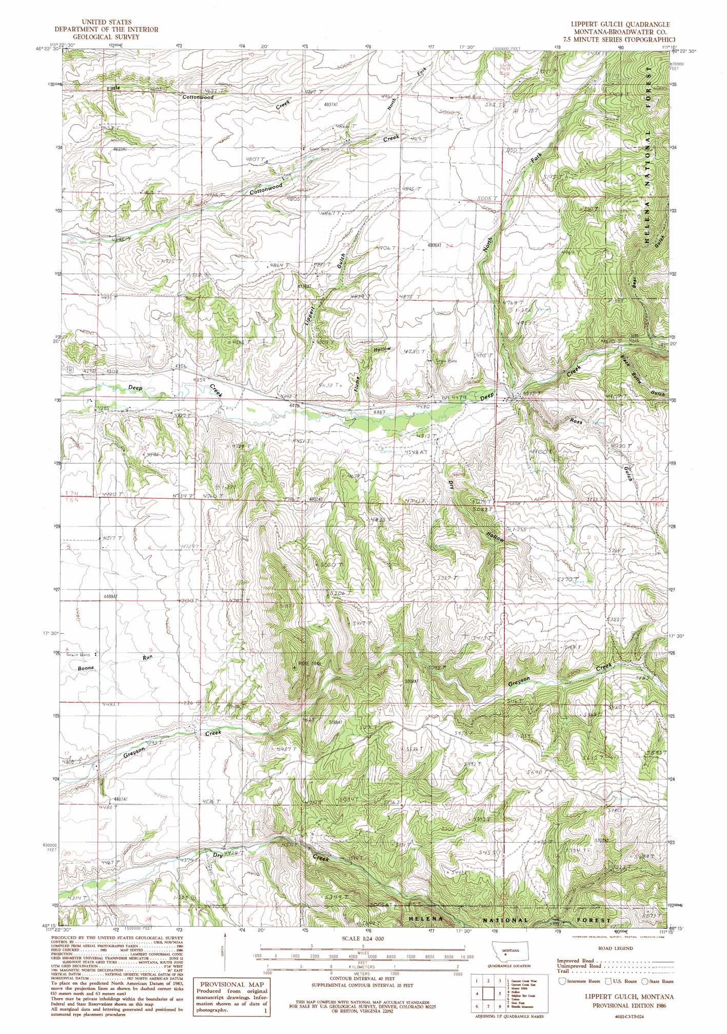
Lippert Gulch Topo Map Montana
To zoom in, hover over the map of Lippert Gulch
USGS Topo Quad 46111c3 - 1:24,000 scale
| Topo Map Name: | Lippert Gulch |
| USGS Topo Quad ID: | 46111c3 |
| Print Size: | ca. 21 1/4" wide x 27" high |
| Southeast Coordinates: | 46.25° N latitude / 111.25° W longitude |
| Map Center Coordinates: | 46.3125° N latitude / 111.3125° W longitude |
| U.S. State: | MT |
| Filename: | o46111c3.jpg |
| Download Map JPG Image: | Lippert Gulch topo map 1:24,000 scale |
| Map Type: | Topographic |
| Topo Series: | 7.5´ |
| Map Scale: | 1:24,000 |
| Source of Map Images: | United States Geological Survey (USGS) |
| Alternate Map Versions: |
Lippert Gulch MT 1986, updated 1986 Download PDF Buy paper map Lippert Gulch MT 2001, updated 2004 Download PDF Buy paper map Lippert Gulch MT 2011 Download PDF Buy paper map Lippert Gulch MT 2014 Download PDF Buy paper map |
| FStopo: | US Forest Service topo Lippert Gulch is available: Download FStopo PDF Download FStopo TIF |
1:24,000 Topo Quads surrounding Lippert Gulch
Canyon Ferry Se |
Diamond City |
Boulder Baldy |
Gipsy Lake |
Hanson Reservoir |
Townsend Ne |
Gurnett Creek West |
Gurnett Creek East |
Mount Edith |
Alkali Lake |
Townsend |
Holker |
Lippert Gulch |
Sulphur Bar Creek |
Battle Mountain |
Parker |
Toston |
Deer Park |
Sixmile Mountain |
Francis |
Plunket Lake |
Lombard |
Roy Gulch |
Maudlow |
Blacktail Mountain |
> Back to 46111a1 at 1:100,000 scale
> Back to 46110a1 at 1:250,000 scale
> Back to U.S. Topo Maps home
Lippert Gulch topo map: Gazetteer
Lippert Gulch: Streams
North Fork Cottonwood Creek elevation 1473m 4832′North Fork Deep Creek elevation 1378m 4520′
Lippert Gulch: Valleys
Bear Gulch elevation 1435m 4708′Black Butte Gulch elevation 1408m 4619′
Dry Hollow elevation 1401m 4596′
Flume Hollow elevation 1356m 4448′
Lippert Gulch elevation 1340m 4396′
Ross Gulch elevation 1385m 4543′
Lippert Gulch: Wells
06N03E04AC__01 Well elevation 1420m 4658′06N03E04BC__01 Well elevation 1384m 4540′
06N03E05DD__01 Well elevation 1368m 4488′
06N03E08AD__01 Well elevation 1361m 4465′
06N03E09BB__01 Well elevation 1376m 4514′
06N03E17DA__01 Well elevation 1328m 4356′
07N03E14AD__01 Well elevation 1475m 4839′
07N03E14AD__02 Well elevation 1475m 4839′
07N03E14BD__01 Well elevation 1482m 4862′
07N03E14BD__02 Well elevation 1482m 4862′
07N03E14BD__03 Well elevation 1482m 4862′
07N03E14DD__01 Well elevation 1499m 4917′
07N03E15DD__01 Well elevation 1414m 4639′
07N03E15DD__02 Well elevation 1414m 4639′
07N03E24AB__01 Well elevation 1522m 4993′
07N03E25DABB01 Well elevation 1439m 4721′
07N03E28CC__01 Well elevation 1306m 4284′
07N03E28DB__01 Well elevation 1374m 4507′
07N03E28DC__01 Well elevation 1314m 4311′
07N03E32AA__01 Well elevation 1293m 4242′
07N03E32AA__02 Well elevation 1293m 4242′
07N03E33BA__01 Well elevation 1299m 4261′
07N03E34BA__01 Well elevation 1325m 4347′
Lippert Gulch digital topo map on disk
Buy this Lippert Gulch topo map showing relief, roads, GPS coordinates and other geographical features, as a high-resolution digital map file on DVD: