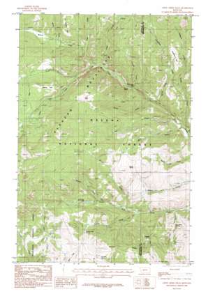
Crow Creek Falls Topo Map Montana
To zoom in, hover over the map of Crow Creek Falls
USGS Topo Quad 46111c7 - 1:24,000 scale
| Topo Map Name: | Crow Creek Falls |
| USGS Topo Quad ID: | 46111c7 |
| Print Size: | ca. 21 1/4" wide x 27" high |
| Southeast Coordinates: | 46.25° N latitude / 111.75° W longitude |
| Map Center Coordinates: | 46.3125° N latitude / 111.8125° W longitude |
| U.S. State: | MT |
| Filename: | o46111c7.jpg |
| Download Map JPG Image: | Crow Creek Falls topo map 1:24,000 scale |
| Map Type: | Topographic |
| Topo Series: | 7.5´ |
| Map Scale: | 1:24,000 |
| Source of Map Images: | United States Geological Survey (USGS) |
| Alternate Map Versions: |
Crow Creek Falls MT 1985, updated 1986 Download PDF Buy paper map Crow Creek Falls MT 2001, updated 2004 Download PDF Buy paper map Crow Creek Falls MT 2011 Download PDF Buy paper map Crow Creek Falls MT 2014 Download PDF Buy paper map |
| FStopo: | US Forest Service topo Crow Creek Falls is available: Download FStopo PDF Download FStopo TIF |
1:24,000 Topo Quads surrounding Crow Creek Falls
> Back to 46111a1 at 1:100,000 scale
> Back to 46110a1 at 1:250,000 scale
> Back to U.S. Topo Maps home
Crow Creek Falls topo map: Gazetteer
Crow Creek Falls: Basins
Slim Sam Basin elevation 1899m 6230′Crow Creek Falls: Falls
Crow Creek Falls elevation 1718m 5636′Crow Creek Falls: Flats
Longfellow Park elevation 2016m 6614′Manley Park elevation 2225m 7299′
Poe Park elevation 2287m 7503′
Crow Creek Falls: Lakes
South Fork Lakes elevation 2034m 6673′Crow Creek Falls: Mines
Ballard Mine elevation 2392m 7847′Ballard Mine elevation 2360m 7742′
Big Tizer Wildcat Mine elevation 2067m 6781′
Bonanza Mine elevation 2093m 6866′
Bonanza Mine elevation 2138m 7014′
Boulaway Mine elevation 2034m 6673′
Calahan Mine elevation 2124m 6968′
Calahan/Pataloma Mine elevation 2181m 7155′
Golden Age Mine elevation 2027m 6650′
Hog Hollow Mine elevation 2056m 6745′
Little Tizer Wildcat Mine elevation 2329m 7641′
NE NE Section 3 Mine elevation 2425m 7956′
Pataloma Mine elevation 2205m 7234′
Crow Creek Falls: Post Offices
Gold Dust Post Office (historical) elevation 1762m 5780′Crow Creek Falls: Ridges
Bonanza Ridge elevation 2253m 7391′Crow Creek Falls: Springs
Bomar Spring elevation 2041m 6696′Bonanza Spring elevation 2082m 6830′
Church Spring elevation 1748m 5734′
Hog Hollow Spring elevation 1818m 5964′
Swamp Creek Spring elevation 2099m 6886′
Two Sam Spring elevation 2135m 7004′
Crow Creek Falls: Streams
Bear Creek elevation 1631m 5351′Bear Gulch elevation 1620m 5314′
Big Tizer Creek elevation 1822m 5977′
Blacker Creek elevation 1881m 6171′
Clear Creek elevation 1958m 6423′
Crazy Creek elevation 1796m 5892′
Dewey Creek elevation 1669m 5475′
Eagle Creek elevation 1620m 5314′
Eureka Creek elevation 1625m 5331′
Falls Creek elevation 1733m 5685′
Hall Creek elevation 1632m 5354′
Little Tizer Creek elevation 1937m 6354′
Longfellow Creek elevation 1743m 5718′
Moose Creek elevation 2021m 6630′
Spring Creek elevation 1662m 5452′
Swamp Creek elevation 1775m 5823′
Teakettle Creek elevation 1839m 6033′
Warner Creek elevation 1796m 5892′
Wilson Creek elevation 1824m 5984′
Crow Creek Falls: Valleys
Hog Hollow elevation 1730m 5675′Crow Creek Falls digital topo map on disk
Buy this Crow Creek Falls topo map showing relief, roads, GPS coordinates and other geographical features, as a high-resolution digital map file on DVD:


